Sunrise gets the press. The blogs are full of pre-dawn alarm tips, frozen tripod-leg warnings, and Mesa Arch crowd management strategies. Sunset is quieter in the photography literature — probably because it requires less suffering, which makes it feel less earned. That logic is wrong.
The geometry of sunset light is categorically different from sunrise, not better or worse but operating on a completely separate axis. Where sunrise fires the east faces of mountains and cliffs and gradually reveals detail from shadow, sunset wraps the west-facing features in long, warm, horizontal light that builds in intensity for forty-five minutes before the sun touches the horizon — then continues to transform the scene for another hour into blue hour. The transition from golden hour through alpenglow to full blue hour is one continuous photographic event that rewards staying put long after most photographers have packed up.
The twelve spots below are deliberately distinct from the sunrise guide. No duplicated locations, different parks in several cases, and a focus on the specific qualities that make each location perform at the end of the day rather than the beginning of it. Sunset geometry means facing west or northwest. Subject matter that glows — pale sandstone, granite, glacial ice, the Panamint Range from 5,000 feet — rather than subject matter that catches angled sidelight.
One note about blue hour, which this guide treats as an extension of the sunset session rather than a separate event: the forty-five to sixty minutes after sunset, when the sky descends through purple and cerulean before going fully dark, is often the technically most interesting window of the day. I’ll address blue-hour technique in its own section. But the short version is: do not leave when the sun goes below the horizon. The session is half over at that point.
1. Tunnel View — Yosemite National Park, California
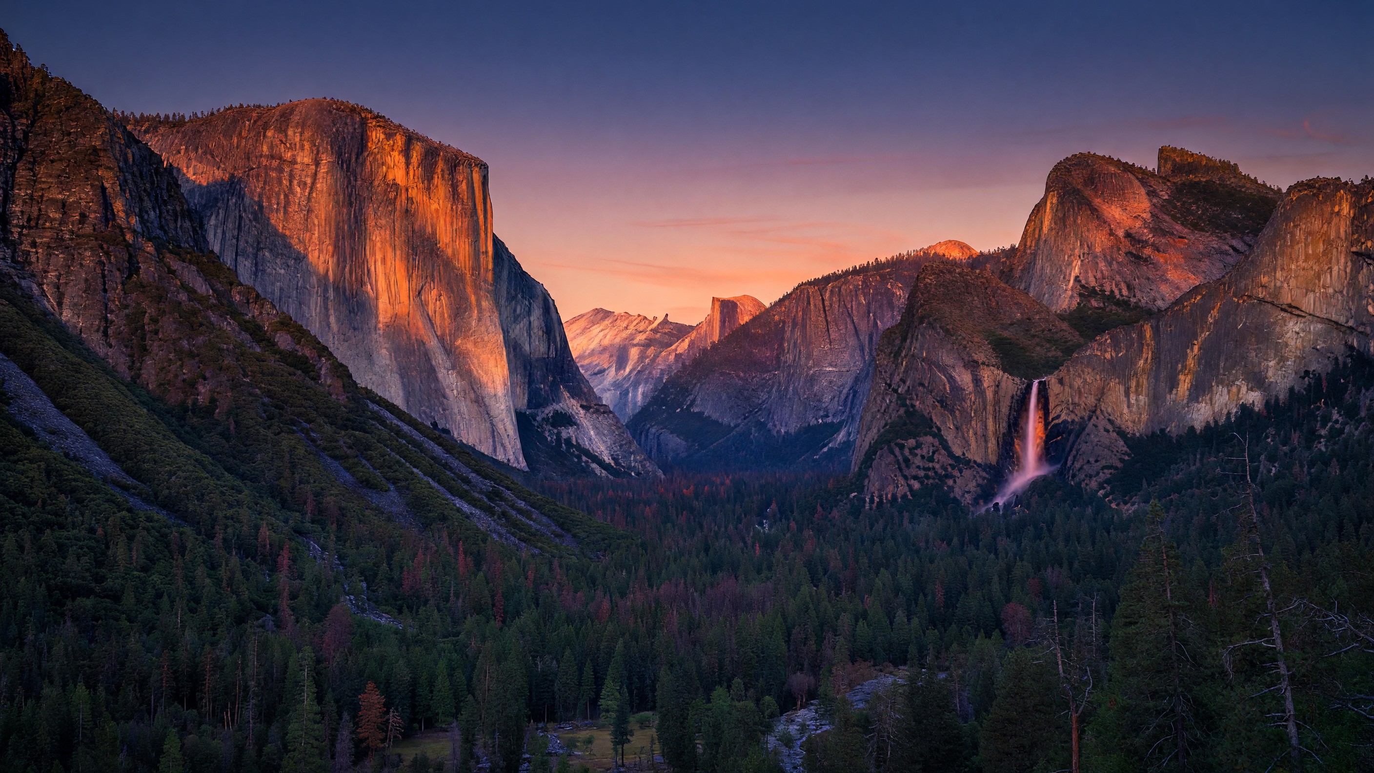
Tunnel View is perhaps the most recognizable single photographic frame in the National Park System — the sweeping valley view from the east portal of the Wawona Tunnel, with El Capitan’s 3,000-foot face on the left, Bridalveil Fall on the right, and Half Dome positioned precisely in the distance. Ansel Adams worked this composition. Photographers have stood here for eight decades at sunset, and the reason is straightforward: the valley runs roughly east-west, the setting sun lights El Capitan’s southwest face directly, and as the sun descends below the Valley rim, the warm light retreats upward on the granite walls into what the Yosemite photography community calls alpenglow — a pink-to-rose phenomenon on the upper granite as ambient light cools below.
At sunrise, Tunnel View shows a different version: the morning sun hits El Capitan’s east face while the valley floor stays dark. At sunset, the logic inverts. The valley floor picks up warm reflected light first, the walls light in sequence from bottom up as direct sun drops, and the final minutes before the sun clears the western rim are often the most saturated color window of the day. Stay through alpenglow, which runs another 10–15 minutes after direct light disappears.
Arrival: 60 minutes before sunset. The Tunnel View parking area is a short lot off Wawona Road (CA-41) at the east portal of the Wawona Tunnel, and it fills early on peak days. Overflow parking exists at nearby turnouts. Note that Yosemite Valley operates a timed-entry reservation system during peak season — verify current requirements at nps.gov/yose before planning your trip. Late-afternoon timed-entry windows are typically less contested than morning windows.
Light geometry: The sun sets to the southwest. El Capitan’s southwest face receives direct sun for roughly 45 minutes before sunset. Half Dome, positioned northeast of the viewpoint, catches the pink alpenglow on its northwest face in the final minutes and is often more interesting compositionally than El Capitan at that stage.
Focal lengths: 24–35mm captures the full valley panorama with both walls framing the composition. A 50–70mm compression brings Half Dome and El Capitan into a tighter relationship and reduces the open sky.
Blue-hour value: High. After alpenglow fades, the valley falls into a luminous deep blue that makes the granite walls appear to glow from within. City-light reflection from Yosemite Valley’s lodging cluster is enough to keep the valley floor from going pure black. This is a 15-minute blue-hour window worth staying for.
Tripod: Required from alpenglow onset. Base exposure times reach 4–15 seconds at ISO 400 during blue hour.
2. Hopi Point — Grand Canyon National Park, Arizona
Hopi Point is the South Rim’s designated sunset overlook for good reason: it is a narrow south-facing peninsula that extends into the Canyon’s airspace on both sides, giving unobstructed horizon views to the west without the sidewall clipping that limits other South Rim viewpoints. At the other overlooks, canyon walls partially block the sunset sky. At Hopi Point, you see the full arc of the western horizon drop over the inner gorge. The light’s last thirty minutes, firing horizontally through the canyon’s airspace, illuminates layer after layer of Colorado Plateau geology in a progression from warm gold through orange through deep red.
The Hermit Road shuttle stops at Hopi Point specifically for the sunset crowd, which should tell you this is the park’s consensus choice. That also means competition for rim position in the final 20 minutes can be serious. The point is wide enough for many photographers to set up, but the best positions — looking west along the canyon’s south arm, with the inner gorge visible below — are worth claiming early.
Arrival: 60–70 minutes before sunset. The Hermit Road shuttle operates west from Grand Canyon Village. Hopi Point is approximately 4.5 miles from the village; budget shuttle travel time accordingly. Private vehicles are not permitted on Hermit Road during peak season — check nps.gov/grca for current Hermit Road shuttle schedules and seasonal operating dates. Off-season (typically December through February), private vehicles can drive Hermit Road, which gives more flexibility.
Light geometry: The canyon runs roughly east-west at this section. The setting sun fires almost directly up the canyon’s east-west axis in the late afternoon, illuminating the layer-cake geology of the Kaibab, Toroweap, Coconino, and Hermit formations in sequence. The effect intensifies in the 20 minutes before the sun hits the horizon.
Focal lengths: 24–50mm for the panoramic canyon sweep; 100–200mm to compress distant formations on the North Rim into stacked telephoto layers with atmospheric haze providing depth cues. Both approaches produce strong images at this location.
Blue-hour value: Very high. The inner gorge holds twilight far longer than the rims — the Colorado River 4,500 feet below continues to reflect cool sky light as the rims go dark. A 5-minute blue-hour exposure at ISO 400, f/8 can reveal river detail and rim silhouette simultaneously. Stay for it.
Note: Arizona does not observe Daylight Saving Time, which makes Grand Canyon sunset times feel earlier than nearby Utah parks during summer months. Verify local sunset time using a park-specific calculator before your trip.
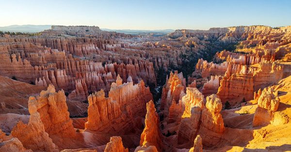
3. Sunset Point — Bryce Canyon National Park, Utah
The name is not accidental. Sunset Point is the West-facing main overlook of Bryce Canyon’s central amphitheater, positioned directly above the Navajo Loop Trail and the Wall Street descent corridor. Thor’s Hammer — the park’s most photographed hoodoo, a tall spire with a distinctive cap rock — is visible directly below the rim. In the 30–40 minutes before sunset, horizontal light from the west turns the hoodoos a deep rosé-to-crimson that is almost biological in its intensity, a color saturation that happens because the Claron limestone’s iron oxide content reacts differently to low-angle light than to overhead sun.
The Wall Street descent context: The trail directly below Sunset Point drops into Wall Street, a slot-like ravine between towering hoodoo walls. Walking into Wall Street an hour before sunset and then ascending as the light dies is one of the genuinely underrated experiences in Western park photography. The slot narrows enough that warm light fires through the upper hoodoo walls while the lower canyon stays cool — two color temperatures in one frame, which RAW captures correctly when JPEGs tend to blow out the lit walls.
Arrival: 50–60 minutes before sunset at the overlook; 90 minutes before sunset if you want to descend into Wall Street first. The park shuttle serves Sunset Point from late spring through fall; the parking area at the visitor center complex is approximately 0.5 miles from the overlook. Altitude is approximately 8,000 feet — hand warmers matter by September.
Light geometry: Sunset Point faces west. The hoodoos below and immediately west of the overlook receive direct sunset light; formations further into the amphitheater catch oblique light from the side, creating shadow definition that brings out hoodoo texture. The color shift from yellow-gold to orange-red happens rapidly in the last 20 minutes of direct light.
Focal lengths: 50–85mm for individual hoodoo clusters including Thor’s Hammer detail; 24–35mm for the full amphitheater context. A 135mm picks out the color banding in distant hoodoo walls with strong graphic compression.
Blue-hour value: Moderate. After direct light fades, the amphitheater goes cool quickly at this elevation. The 15 minutes of alpenglow on the rim peaks can be worth waiting for. Full blue hour at Bryce in summer is often too dark for handheld shooting — tripod required from alpenglow onset.
The Bryce Canyon National Park guide covers the Navajo Loop descent and Wall Street in more detail, including seasonal trail conditions.
4. Dead Horse Point State Park — Colorado River Goosenecks, Utah
Dead Horse Point is a Utah State Park, not a national park — but omitting it from any honest guide to Western sunset photography would be an act of editorial negligence. The point is a narrow mesa cap 2,000 feet above the Colorado River, where the river makes a complete 270-degree loop around the mesa below in what geologists call an entrenched meander or gooseneck. At sunset, the western light fires into the canyon, turns the river surface to gold, and the Canyonlands basin beyond fills with shadow while the Canyonlands buttes catch the last red light on their flat tops. It is a sunset that operates on multiple depth planes simultaneously — river below, mesa floor level, distant Canyonlands formations, sky — and a single exposure cannot hold all of them.
The composition logic here is different from Mesa Arch at sunrise. Dawn at Mesa Arch is about the arch frame and the canyon depth; sunset at Dead Horse Point is about the gooseneck geometry and the shadow-and-light interplay across horizontal distance. This is fundamentally a wide-to-mid-telephoto landscape — there is no architectural subject to fill the foreground, only the geological abstraction of the meander viewed from above.
Arrival: 60 minutes before sunset. Dead Horse Point is approximately 32 miles from Moab via US-191 and UT-313 — the same road that leads to Canyonlands Island in the Sky. The state park charges a separate entrance fee (Utah State Parks pass or per-vehicle fee). The main overlook is a short walk from the parking area.
Light geometry: The mesa faces generally west-southwest. The Colorado River far below catches direct light in the late afternoon; the canyon walls in shadow create the contrast that makes the river gooseneck visible as a compositional element. The effect is strongest in the 30 minutes before sunset.
Focal lengths: 24–50mm for the full gooseneck view and Canyonlands basin; 100–150mm to compress the river bends and flatten the perspective into a more graphic meander pattern. The wide and telephoto interpretations of this location look like different photographs — both are worth shooting.
Blue-hour value: Very high. After sunset, the river surface transitions from gold to a steel-blue that contrasts beautifully with the now-orange sandstone walls. The 20-minute blue-hour window here is among the strongest of any location on this list.
5. The Watchman Overlook — Zion National Park, Utah
The Watchman is the massive peak that stands sentinel at Zion Canyon’s south entrance — a 6,555-foot tower of Navajo Sandstone with a distinctive flat-capped summit that glows amber and copper in the last hour of daylight. The standard photography position is from the south bank of the Virgin River, near the Watchman Campground, looking north with the peak centered over the river. At sunset, the peak catches the warm western light while the canyon mouth behind it goes cool — a natural warm-cool separation that requires no post-processing filter to achieve.
The Watchman is a fundamentally different compositional premise from the deeper canyon photography possible at Angels Landing or Observation Point. Those locations offer interior canyon drama. The Watchman at sunset is about the entrance sentinel, the river foreground, the light-to-shadow transition at the canyon mouth. It is a gentler, more classical landscape composition — and it is one of the least crowded sunset positions in Zion, because the crowds concentrate on the canyon shuttle overlooks and Angels Landing rather than at the park entrance.
Arrival: 45 minutes before sunset. The parking area for the Watchman trailhead and campground is immediately inside the south entrance, accessible without a shuttle. Walk to the river bank for the primary composition.
Light geometry: The Watchman faces southwest. It receives direct light from roughly two hours before sunset, building in warmth as the sun descends. The transition from golden to alpenglow on the summit sandstone, against a darkening canyon behind, takes about 10 minutes and is the sharpest color-contrast window.
Focal lengths: 70–135mm is the standard approach, compressing the peak slightly and maintaining the river-foreground relationship. 50mm gives a wider environmental frame that includes more canyon mouth. Wide-angle under 35mm tends to make the peak appear small and the river too dominant.
Blue-hour value: Good. The canyon mouth continues to hold reflected sky light after direct sun is gone, and the Watchman’s upper sandstone holds a residual warm tone against the cooling canyon background for 8–10 minutes. The full blue-hour transition here is subtle — a 20-minute window worth working.
Tripod: Required from alpenglow onset for any exposure quality at ISO 400.
The Zion National Park guide covers permit logistics and the full canyon photography context.
6. Keys View — Joshua Tree National Park, California
Keys View is a designated overlook at 5,185 feet in Joshua Tree’s Little San Bernardino Mountains, looking south and southwest across the entirety of the Coachella Valley. On a clear day — and winter and spring are vastly clearer than summer — the visible landmarks from this overlook are extraordinary: the shimmering surface of the Salton Sea (233 feet below sea level, approximately 45 miles distant), the Santa Rosa Mountains beyond, the linear scar of the San Andreas Fault running through the valley floor, and on exceptional days, Signal Mountain in Mexico nearly 80 miles away. At sunset, the Coachella Valley floor transitions from dry brown to a luminous warm gold while the fault zone shadows deepen and the Salton Sea, a vast saline lake, turns the color of hammered copper.
This is a sunset composition with a strong conceptual hook: you are looking at geologic time made visible. The valley floor below is actively being shaped by the same fault system that created the mountains you’re standing on. The photography is partly about light and partly about scale — the valley is enormous, and the human figure is meaningless at this perspective.
Arrival: 50 minutes before sunset. Keys View Road is paved and accessible to all vehicles; the parking area is immediately at the overlook. Located in Joshua Tree’s southern section, approximately 16 miles from the park’s west entrance at Joshua Tree Village. Entrance fees required (America the Beautiful pass honored). Check nps.gov/jotr for current conditions and seasonal hour details.
Light geometry: Keys View faces southwest. The valley below receives the full western sun in late afternoon; the fault-scarp shadows emerge in the final 30 minutes of direct light. The Salton Sea catches a long reflection of the setting sun that is often the brightest element in the frame.
Focal lengths: 50–100mm for the compressed valley-to-mountain relationship; 24mm for a wide scene that includes foreground cactus and the full valley sweep. The wide composition requires careful foreground selection to avoid dead air in the lower frame.
Blue-hour value: Exceptional. After sunset, the Salton Sea holds sky-blue reflection against the darkening valley floor for 20–25 minutes. The blue-hour window here is longer than at most desert locations because the valley below is so open and catches so much sky.
7. Dante’s View — Death Valley National Park, California
Dante’s View sits at 5,475 feet on the crest of the Black Mountains, looking west across the full width of Badwater Basin — the lowest point in North America at 282 feet below sea level. The view geometry is almost impossible to describe adequately: the salt flat is nearly 200 square miles of white and silver stretched below, and the Panamint Range across the valley rises to Telescope Peak at 11,049 feet. You stand on a ridge at mid-altitude and look both down into a basin that is below sea level and up at a summit that is more than 11,000 feet above it — a vertical range of over 11,300 feet visible from a single position. At sunset, the Panamint Range transitions through gold and orange to a steel-blue-purple as the last direct light leaves the salt flat below. The word “alpenglow” applies in reverse here: the high peaks light last and cool slowest.
Arrival: 60 minutes before sunset. The road to Dante’s View is paved and accessible to standard vehicles; the final 13 miles of Dante’s View Road branch off CA-190 east of Furnace Creek. Plan for a 25–30 minute drive from Furnace Creek. Note that Death Valley’s extreme heat makes timing critical in summer — the elevation at Dante’s View (5,475 feet) is significantly cooler than the valley floor, but summer desert sunset temperatures can still be above 90°F at this elevation. October through April is the practical photography season for most visitors.
Light geometry: Dante’s View faces west across the Basin. The salt flat below catches direct late-afternoon light in a progression from warm yellow through gold; the Panamint peaks receive direct light from the west until sunset, then transition through alpenglow. The sequence — lit flat, then lit peaks, then just alpenglow on peaks, then blue hour on everything — takes about 60 minutes to complete and is continuous.
Focal lengths: 24–50mm for the full Basin panorama and Panamint range; 100–200mm for telephoto compressions of the Panamint crest against the salt flat below. The telephoto compression at this location makes the Basin appear to rise toward the peaks in a way that the wide-angle view does not convey.
Blue-hour value: Outstanding. The white salt flat holds reflected sky light longer than any other surface I’ve photographed in the West. In blue hour, Badwater Basin glows a luminous silver-blue against the darkening Panamint silhouette. This is a 30-minute blue-hour window — substantially longer than most locations — because the reflective flat extends the usable light.
Tripod: Essential. The ridge is exposed to wind, and exposures of 6–20 seconds are common during blue hour.
Check the NPS Death Valley conditions page at nps.gov/deva before visiting — road conditions and seasonal access vary significantly.
8. Logan Pass and the Hidden Lake Overlook — Glacier National Park, Montana
Logan Pass at 6,646 feet is the high point of Going-to-the-Sun Road, and the subalpine meadow above it is one of the most photographically saturated environments in the national park system. In July and August, the meadow runs deep with wildflowers — beargrass, glacier lily, Indian paintbrush, and blue camas in sequence across the growing season. Hidden Lake Overlook, reached by the 2.7-mile round-trip boardwalk trail, delivers a direct view of Hidden Lake below and Bearhat Mountain rising above it — a distinctive pyramidal summit that catches alpenglow in a sharp triangle of pink-to-red against the cooling sky behind it. At sunset from the overlook, Bearhat Mountain is the primary subject, and the last 20 minutes of light on its northwest face are a sustained alpenglow display.
Timing note: Logan Pass sees afternoon thunderstorms regularly from mid-July through August — the standard afternoon alpine weather pattern. Plan your sunset timing around this. If storms move through early, the clearing aftermath often produces better light than an unobstructed sunset; storm-lit alpenglow on Bearhat Mountain and the Garden Wall can be extraordinary. If the storm is still active at sunset, retreat to lower elevation.
Arrival: 60 minutes before sunset at the Logan Pass trailhead. The Hidden Lake Overlook is 1.35 miles from the parking lot — a brisk 25-minute walk on boardwalk with some elevation gain. Add 10 minutes if you’re arriving at altitude for the first time. Logan Pass parking fills early on peak summer days; if the lot is full, take the park shuttle from the St. Mary side or Avalanche Creek. Check nps.gov/glac for current shuttle schedules.
Light geometry: Bearhat Mountain’s northwest face receives direct light in the late afternoon and catches alpenglow in the final 15 minutes before full shadow. Hidden Lake itself, positioned due south of the overlook, turns a deeper turquoise as the light cools — a color shift that is most dramatic in RAW processing.
Focal lengths: 50–100mm for Bearhat Mountain and the lake below in a single frame; 135–200mm to isolate the peak and drop the lake, making the alpenglow the dominant subject.
Blue-hour value: High for mountain photography. Bearhat Mountain holds its silhouette against a deeply saturated blue sky for 20–25 minutes after the alpenglow fades, and the lake below picks up the sky color in calm conditions.
Wildlife note: Mountain goats and bighorn sheep are regularly present on the rocky slopes above the Hidden Lake Overlook boardwalk and do not move off for photographers. Keep 25 yards of distance. Grizzly bear encounters in this zone are not rare — carry bear spray.
The Glacier National Park guide covers Going-to-the-Sun Road logistics, the 2025 reservation system changes, and the Many Glacier valley in detail.
9. Cathedral Rocks View — Yosemite Valley, California
Cathedral Rocks is the massive granite formation on the south wall of Yosemite Valley, directly opposite El Capitan and immediately west of Bridalveil Fall. While Tunnel View is the Yosemite sunset headline, Cathedral Rocks offers the companion composition with significantly fewer people: standing on the valley floor near Sentinel Beach or the Cathedral Rocks picnic area, you can shoot Cathedral Rocks directly as they catch the warm light of late afternoon while the valley floor around you is still lit. The formation includes three summits — the Cathedral Spires — and the 2,900-foot wall below them drops straight to the valley floor, providing a close foreground-to-sky composition that Tunnel View’s distant perspective does not.
This is the close-up version of the Yosemite sunset. Where Tunnel View gives you the whole valley in a single frame, the Cathedral Rocks position gives you one massive granite wall filling most of the sky, warm from base to summit, with the meadow floor in late-afternoon light below. Both approaches are worth doing on a multi-day Yosemite visit; they are not interchangeable.
Arrival: 45 minutes before sunset. Access via Southside Drive to the Cathedral Rocks picnic area or Sentinel Beach day-use area. Both have small parking areas; Sentinel Beach is slightly less trafficked. Note that Yosemite Valley timed-entry reservations apply during peak season — check nps.gov/yose for current entry windows before your trip.
Light geometry: Cathedral Rocks faces northeast-to-east. The late afternoon sun from the southwest hits the formation at a raking angle that reveals every crack and texture in the granite. In the final 30 minutes of direct light, the warm-to-hot color temperature saturates the yellow-gray granite into deep amber. Bridalveil Fall is visible on the left edge of the composition from most positions.
Focal lengths: 35–85mm for the full formation-to-meadow composition; 135–200mm for tight work on the Cathedral Spires themselves, isolating the upper rock against sky.
Blue-hour value: Moderate. The valley floor goes to shadow quickly after direct light, and Cathedral Rocks’ north-facing upper spires hold the last residual warmth. The 10–15 minute transition is worth staying for if you’re already set up.
10. Cape Royal — Grand Canyon North Rim, Arizona
Cape Royal is the eastern terminus of the North Rim’s Cape Royal Road — a 23-mile drive from Grand Canyon Lodge through ponderosa pine and Kaibab Plateau to a promontory at 7,865 feet that delivers one of the most unobstructed sunset views available anywhere on the Canyon’s rims. The road passes Walhalla Overlook, Point Imperial, and multiple unnamed viewpoints along the way; Cape Royal itself is a peninsula projecting into the Canyon’s eastern section, with the Colorado River visible 5,000 feet below and the Unkar Delta visible to the northeast. The viewpoint has a natural arch — Angels Window — through which you can look directly down to the river below.
The North Rim’s sunset logic is different from the South Rim. The North Rim sits 1,000 feet higher and is significantly less visited (roughly 10% of Grand Canyon visitors reach the North Rim in any given year). Cape Royal specifically sees far fewer sunset photographers than Hopi Point, which means you can usually find a prime position without planning for a crowd. The Canyon at Cape Royal runs more east-west at this section, and at sunset, the Colorado River below and the Palisades of the Desert formation to the east catch direct warm light while the inner gorge shadows deepen.
Arrival: 70 minutes before sunset. The drive from the North Rim lodge area to Cape Royal takes 40–45 minutes; plan accordingly. The North Rim is open mid-May through mid-October, depending on snowpack — verify dates at nps.gov/grca before making the trip. The North Rim is a serious destination commitment: it’s a 4.5-hour drive from Las Vegas and a 215-mile drive from the South Rim Visitor Center.
Light geometry: Cape Royal faces generally south and southeast. At sunset, the far canyon walls to the south receive warm light while the formations immediately below the promontory fall into shadow, creating the classic Canyon depth contrast. The Colorado River bend visible below lights up in the final 15 minutes before sunset.
Focal lengths: 24–50mm for the full panoramic canyon sweep; 100–200mm for compressed telephoto work on the Palisades of the Desert to the east, which catch long sunset light.
Blue-hour value: High. The Canyon’s depth holds twilight light — the river and lower formations visible below the promontory continue to register sky reflection long after the rim is fully in shadow. Stay for the full blue-hour window.
Angels Window: The natural arch is worth a 10-minute walk from the main promontory. The through-arch view toward the Canyon and river below is a distinct composition from the main Cape Royal overlook — use 24–35mm.
11. Hurricane Hill — Olympic National Park, Washington
Hurricane Ridge sits at 5,242 feet above Port Angeles, and its long south-facing ridge delivers one of the few genuine subalpine sunsets available in the Pacific Northwest without serious hiking commitment. The standard overlook at the Hurricane Ridge parking area faces south toward the Olympic Mountains; the Hurricane Hill Trail adds 3.2 miles round trip to a viewpoint at the ridge’s western terminus that adds the critical northern dimension: looking northwest from Hurricane Hill, you can see the Strait of Juan de Fuca, the Gulf Islands, and, on clear days, the Canadian Gulf Islands and Vancouver Island’s interior mountains above the water. At sunset from this position, the Olympic peaks glow behind you while the marine geography of the Strait frames the northwest horizon — two different light directions, mountains behind, water ahead.
The marine atmosphere factor: Olympic Peninsula sunsets are dramatically affected by marine layer. The same fog that makes Olympic’s rainforest possible also diffuses and filters the sunset light in ways that can either ruin a session or produce extraordinary soft-light alpenglow depending on the cloud configuration. Arriving on a day with some high cloud cover often produces better color than a perfectly clear evening. Check satellite imagery on the morning of your planned shoot.
Arrival: 70 minutes before sunset to account for the 3.2-mile round trip to Hurricane Hill’s summit viewpoint. The Hurricane Hill Trail is an easy ridge walk with minimal elevation change — once you’re at Hurricane Ridge altitude, the trail undulates along the open subalpine meadow. The Hurricane Ridge Day Lodge burned in May 2023 and has not yet been rebuilt as of this writing; facilities are limited. Check nps.gov/olym for current visitor center status. The access road (17 miles from Port Angeles) closes at the gate after dark — verify current gate hours before starting your hike.
Light geometry: The Olympic peaks to the south and southeast catch direct sunset light on their west faces. The Strait of Juan de Fuca to the north reflects sky light and remains luminous after the peaks go to shadow. The two-direction photographic situation here is unusual and worth planning multiple positions into your session.
Focal lengths: 24–50mm for the Strait panorama looking northwest; 100–200mm for compressed telephoto work on the Olympic peaks to the south in alpenglow.
Blue-hour value: Very high at this elevation and marine location. The Strait of Juan de Fuca holds reflected blue-hour sky for 30–40 minutes after sunset — longer than any inland location on this list. The combination of mountain silhouette to the south and silver-blue marine channel to the north makes the blue-hour session at Hurricane Hill one of the most photogenic endings of any location here.
Wildlife: Black-tailed deer are essentially guaranteed at Hurricane Ridge during summer evenings. Olympic marmots are active on the ridgeline through early September.
12. Schwabacher Landing — Evening Frame, Grand Teton National Park, Wyoming
Schwabacher Landing is the sunrise guide’s second-ranked location — and the reason I’m including it here as an evening alternative is that the light geometry creates a completely different photograph at sunset. In the morning, the Teton Range reflects in the Snake River’s still water because the sun rises behind the camera, lighting the range’s east faces directly. In the evening, the geometry inverts: the sun goes down behind the Teton Range, backlighting the peaks and creating silhouettes with rim-lighting on the glaciated upper flanks. The reflection in the river is no longer a lit-peaks-in-water mirror; it is a backlit-peaks-in-dark-water graphic, which is a different and often more dramatic image.
The evening version of Schwabacher Landing is specifically about the silhouette transition. Plan to arrive while the peaks still have direct side-light from the southwest, shoot through the transition as the sun drops behind the Teton crest, and work the silhouette-plus-rimlight-plus-reflection as the sky cools. The Snake River’s braided meanders still provide foreground interest; the cottonwoods along the bank frame the composition.
Arrival: 50 minutes before sunset. The dirt access road off the Teton Park Road is about a mile; low-clearance vehicles handle it fine in dry conditions. The lot is smaller than the main Teton Park Road pullouts — 10–15 vehicles maximum.
Light geometry: The Teton Range faces east — meaning the peaks are backlit at sunset. The western faces of the peaks are in shadow; the setting sun creates rim-lighting on the upper glaciers and snowfields. The Snake River faces west, catching the sunset sky in reflection.
Focal lengths: 24–50mm for the full river-bend-to-peaks composition; 70–100mm to tighten on specific peaks and their sky-reflection.
Blue-hour value: Exceptional. The river reflection of the blue hour sky is one of the strongest post-sunset compositions in the entire Western park system. With the peaks in silhouette and the river mirror-still (calm conditions), the blue-hour frame here is one I revisit repeatedly.
Companion reading: The Grand Teton National Park guide covers road access, timed-entry details, and multi-sport itinerary planning for the full park.
13. Inspiration Point — Yellowstone National Park, Wyoming
The Grand Canyon of the Yellowstone is one of the park’s most visually violent landscapes — a 1,000-foot-deep, 20-mile-long canyon cut through yellow and orange rhyolite, with the Yellowstone River’s Lower Falls (308 feet, nearly twice the height of Niagara) thundering at its upper end. Inspiration Point is a promontory on the canyon’s north rim, approximately 0.4 miles from the North Rim Drive parking area, that extends into the canyon airspace with a direct line of sight to the Lower Falls and the full east-west run of the canyon below. At sunset, the rhyolite walls shift from yellow-orange to a deeper copper-rust as the sun descends in the southwest, and the falls — continuously producing spray — catch the last light and go from white to pale gold in the final minutes.
Why sunset over sunrise here: The canyon runs roughly east-west, with the falls at the eastern end. Sunrise light from the east would backlight the falls and put the main canyon walls in shadow. Sunset light from the southwest lights the canyon walls directly and illuminates the falls from a lower angle, revealing the spray column as a lit element against the shadowed canyon background. The geometry strongly favors sunset at this location.
Arrival: 50 minutes before sunset. Inspiration Point is accessed via the North Rim Drive, approximately 2 miles east of Canyon Village. The parking area is at a trailhead 0.4 miles from the promontory; the walk is flat and paved. The park’s peak-season congestion can make North Rim Drive slow — factor in extra driving time during July and August. Check nps.gov/yell for current road conditions and seasonal closures.
Light geometry: The canyon walls face generally southwest at this section. Direct sunset light hits them for the final 45 minutes before the sun drops below the plateau rim. The Lower Falls’ spray column, facing east from the falls base, catches oblique warm light from the southwest in the last 20 minutes.
Focal lengths: 70–135mm for the falls-plus-canyon composition from Inspiration Point; 200mm to isolate the falls column and compress the canyon rim layers behind it. Wide-angle is less useful here — the promontory geometry puts most of the dramatic subject matter at mid-to-telephoto distances.
Blue-hour value: Moderate. The canyon is deep and goes to shadow quickly after direct light fades. A 10-minute blue-hour window on the canyon walls and falls spray is achievable before the light becomes too flat for interesting exposures.
Tripod: Essential. The promontory is exposed to wind, and the falls spray can reach the lens in certain wind conditions — carry a lens cloth.
Blue-Hour Technique: The 45 Minutes You’re Probably Missing
Most photographers leave at sunset. The sun touches the horizon, the golden-orange light fades, and the location empties out. This is almost always the wrong decision. The period from sunset to full dark — roughly 45 to 60 minutes depending on latitude, season, and atmospheric conditions — contains two distinct photography phases, each different in character from the golden hour that preceded it.
Alpenglow (0–15 minutes after sunset): The warm light retreating upward on high-elevation subjects — mountain peaks, canyon rims, tall granite walls — is called alpenglow. It is reflected, not direct, sunlight: the sun is below your horizon but still illuminating the upper atmosphere, and that diffused warm light bounces off high-angle surfaces. The color is distinctly pink-to-rose rather than golden; it lasts 10–20 minutes depending on how much atmosphere the light is traveling through, which is why it is more dramatic after storms (more particulate matter in the atmosphere) and why coastal locations like Hurricane Ridge often produce stronger alpenglow than inland desert parks.
Transitional blue hour (15–45 minutes after sunset): As the sky loses its warm light, it transitions through deep purple and cerulean to the distinctive cobalt-blue that photographers call blue hour. This is the moment when the ambient sky is perfectly balanced against artificial and reflected light sources — meaning a subject that would be either blown-out or shadowed at any other time of day is suddenly readable across its full tonal range. Long exposures at ISO 400, f/8, and 8–20 seconds produce images during this window that look like the sky is internally lit.
Gear and settings for blue hour:
| Phase | ISO | Aperture | Shutter | Notes |
|---|---|---|---|---|
| Alpenglow | 200–400 | f/8–f/11 | 1/4s–2s | Tripod required |
| Early blue hour | 400 | f/8 | 2–8s | Mirror lock-up or electronic shutter |
| Full blue hour | 400–800 | f/8 | 8–20s | Remote release essential; check focus |
Shadow and highlight balance: The fundamental technical challenge of blue-hour landscape photography is that the sky is still bright (often 3–5 stops brighter than the foreground) while the foreground is very dark. Three approaches work: (1) HDR bracketing — expose for sky and foreground separately, blend in post; (2) graduated ND filters — a 2-stop reverse grad ND at the horizon holds sky exposure while raising the foreground in-camera; (3) single-exposure RAW with aggressive shadow lifting in Lightroom or Capture One. The third approach works reasonably well on modern sensors but produces more noise in shadow regions than the first two.
Focus in blue hour: Autofocus becomes unreliable in the transitional dark of blue hour. Set focus before the session ends at golden hour, switch to manual, and tape the focus ring. Revisit focus periodically if you’re changing focal lengths. At f/8 and focused at the hyperfocal distance for your lens (typically around 10–15 feet for a 24mm lens), depth of field is generous enough to hold foreground-to-infinity across most landscape compositions.
Weather as a sunset asset: Storm systems produce the most dramatic sunsets in the Western parks. A clearing thunderstorm at 6 p.m. at Hopi Point, Dead Horse Point, or Dante’s View creates conditions that no clear-sky sunset can match: low-angle light firing through breaks in storm cloud, illuminating one section of the Canyon or Basin while another remains under shadow, with the saturated post-storm atmosphere turning the lit sections to deep orange-red. The photographers who chase storm-to-clear transitions consistently produce the most memorable sunset images from Western parks.
Lens and Filter Recommendations for Sunset
Zoom range that covers this list: A 24–105mm or 24–70mm f/4 covers 90% of the compositions on this list. The Grand Canyon telephotos (Hopi Point, Cape Royal) benefit from a 70–200mm. The close-in work at Cathedral Rocks and the Watchman benefits from something in the 85–135mm range. A single 24–70mm plus a 70–200mm covers everything with two lenses.
Graduated ND filters: A 2-stop or 3-stop reverse graduated ND is specifically designed for sunset and sunrise compositions where the brightest zone is at the horizon. Standard grad NDs graduate from dark at the top to clear at the bottom — useful for landscapes with a bright sky above a dark foreground. A reverse grad ND is darkest at the center-horizon and graduates clear toward the top and bottom — exactly the profile of a horizon-glow sunset. Worth owning if you shoot desert canyon sunsets regularly.
Circular polarizer: Less useful at sunset than at midday, but still valuable for reducing glare on river and lake surfaces at oblique angles. The Schwabacher and Dead Horse Point river compositions benefit from a polarizer in the final 30–40 minutes of direct light.
Solid ND filters: A 6-stop or 10-stop ND extends exposures into the 30-second-to-2-minute range, allowing waterfall and river motion blur during golden hour. Useful at the Watchman (Virgin River) and Schwabacher Landing.
Sunset vs. Sunrise Trade-off Summary
For locations that appear in both this guide and the sunrise guide, the comparison is straightforward:
| Location | Sunrise verdict | Sunset verdict |
|---|---|---|
| Tunnel View, Yosemite | Good (El Cap east face lit) | Primary (valley alpenglow, Half Dome rimlit) |
| Schwabacher Landing | Primary (reflection, peaks lit) | Different shot (silhouette + rimlit peaks) |
| Dead Horse Point | — (Dawn not covered) | Primary |
| Sunset Point, Bryce | Secondary (faces west) | Primary |
| Bryce, Sunrise Point | Primary | Secondary |
The geometry rule: east-facing subjects are sunrise subjects. West-facing subjects are sunset subjects. Subjects with no specific aspect — wide canyon panoramas, valley floors, open alpine terrain — work at both, with different color temperatures and shadow directions.
Frequently Asked Questions
What is the best Grand Canyon viewpoint for sunset? Hopi Point on the South Rim is the consensus choice for unobstructed western horizon views over the inner gorge. It’s a designated Hermit Road shuttle stop specifically for sunset crowds. If you prefer fewer people, Cape Royal on the North Rim (open mid-May through mid-October) delivers equally strong sunset views over the eastern Canyon section with significantly less competition for position.
How long before sunset should I arrive at a national park photography spot? A minimum of 60 minutes for locations with any walk involved, 70–90 minutes for locations requiring a shuttle or longer trail approach (Hopi Point via shuttle, Hurricane Hill via trail). The golden hour begins roughly 45 minutes before sunset, and you need to be set up and composed before that window opens. Arriving at sunset to find a position is too late at popular spots.
What is blue hour and how long does it last? Blue hour is the 30–60 minute period after sunset (and before sunrise) when the sky produces a deep, saturated blue light instead of direct sunlight. It is not actually an hour — at low latitudes in summer it can be as short as 25 minutes; at high latitudes (Hurricane Ridge, Glacier) in summer it can extend to 50 minutes because the sun descends at a shallower angle. In practical photography terms, the most usable blue-hour window is typically 15–30 minutes after alpenglow fades — roughly 20–50 minutes post-sunset. Use a tripod and exposures of 8–20 seconds at ISO 400.
Is Dead Horse Point better than Canyonlands for sunset photography? They offer different compositions. Dead Horse Point State Park’s gooseneck overlook shows the Colorado River’s 270-degree meander from 2,000 feet above in a single frame — the defining composition here is the river geometry. Canyonlands Island in the Sky’s Mesa Arch is primarily a sunrise location; its west-facing canyon views are available from the rim, but no single viewpoint organizes the compositional elements as cleanly as Dead Horse Point’s gooseneck overlook does at sunset. If you have one evening in the Moab area, Dead Horse Point’s sunset is the stronger dedicated sunset composition.
Can you shoot sunset in Death Valley in summer? Technically yes — Death Valley has no park closure during summer — but Dante’s View in July and August is dangerous for anyone not prepared for heat, even at elevation. The valley floor can exceed 130°F in summer. Even at 5,475 feet, summer sunset temperatures can be above 90°F with no shade available on the exposed ridge. The practical photography season at Dante’s View is October through April, when temperatures are manageable and the air is clear enough to see the Panamint Range in full detail.
What gear is essential for sunset and blue-hour national park photography? Tripod (non-negotiable from alpenglow onset), remote shutter release or self-timer (2-second delay to avoid camera shake), extra batteries (cold temperatures at elevation deplete batteries quickly), headlamp for the walk out after dark, and at desert canyon parks, a wind-facing lens cloth for dust management. A circular polarizer and reverse graduated ND filter are the two filters that add the most value specifically for sunset landscape work. Dress warmer than feels necessary at the trailhead — standing still at 5,000+ feet for 60 minutes after sunset reveals how fast body temperature drops once direct sun is gone.
Are permits required for national park sunset photography? No photography-specific permits are required for the locations on this list. Standard park entrance fees apply (America the Beautiful pass covers all national parks). Some parks with timed-entry reservation systems — Yosemite in peak season — require a timed-entry reservation; late-afternoon entry windows are typically less contested than morning ones. The North Rim of the Grand Canyon is a closed campground-required overnight for the full sunset-to-stars session; day visitors can drive in and out during operating hours.
Resources
- National Park Service — Find a Park — official park pages with current conditions, road status, and reservation requirements
- National Parks Conservation Association — park advocacy and policy context
- NPS Night Sky Program — blue-hour and dark-sky resources across NPS units, including light pollution data and astronomy event calendars
- NOAA Sunrise/Sunset Calculator — location-specific sunset times and solar angle data
- Recreation.gov — campsite and permit reservations for parks with advance-booking requirements