There is a version of sunrise photography that involves showing up vaguely before 7 a.m. with a phone and hoping something interesting happens. That approach occasionally produces a decent shot. This is not that guide.
The spots below require commitment: a pre-dawn alarm, cold fingers, a tripod, and sometimes a headlamp-lit approach trail in pitch dark. What they return, when you execute correctly, is light that does something you cannot manufacture at any other time of day. The sun at the horizon interacts with rock, water, and cloud in ways that are genuinely irreproducible. I’ve been chasing those first twenty minutes of direct light across Western parks for over a decade, and these twelve locations are the ones I return to or recommend without hesitation.
One clarification before the list: this guide covers Western parks. Acadia’s Cadillac Mountain sunrise is magnificent, but that’s Maine. These twelve are from Utah, Wyoming, Colorado, California, Washington, and Alaska — the parks I know best and the ones that reward dedicated sunrise effort most consistently.
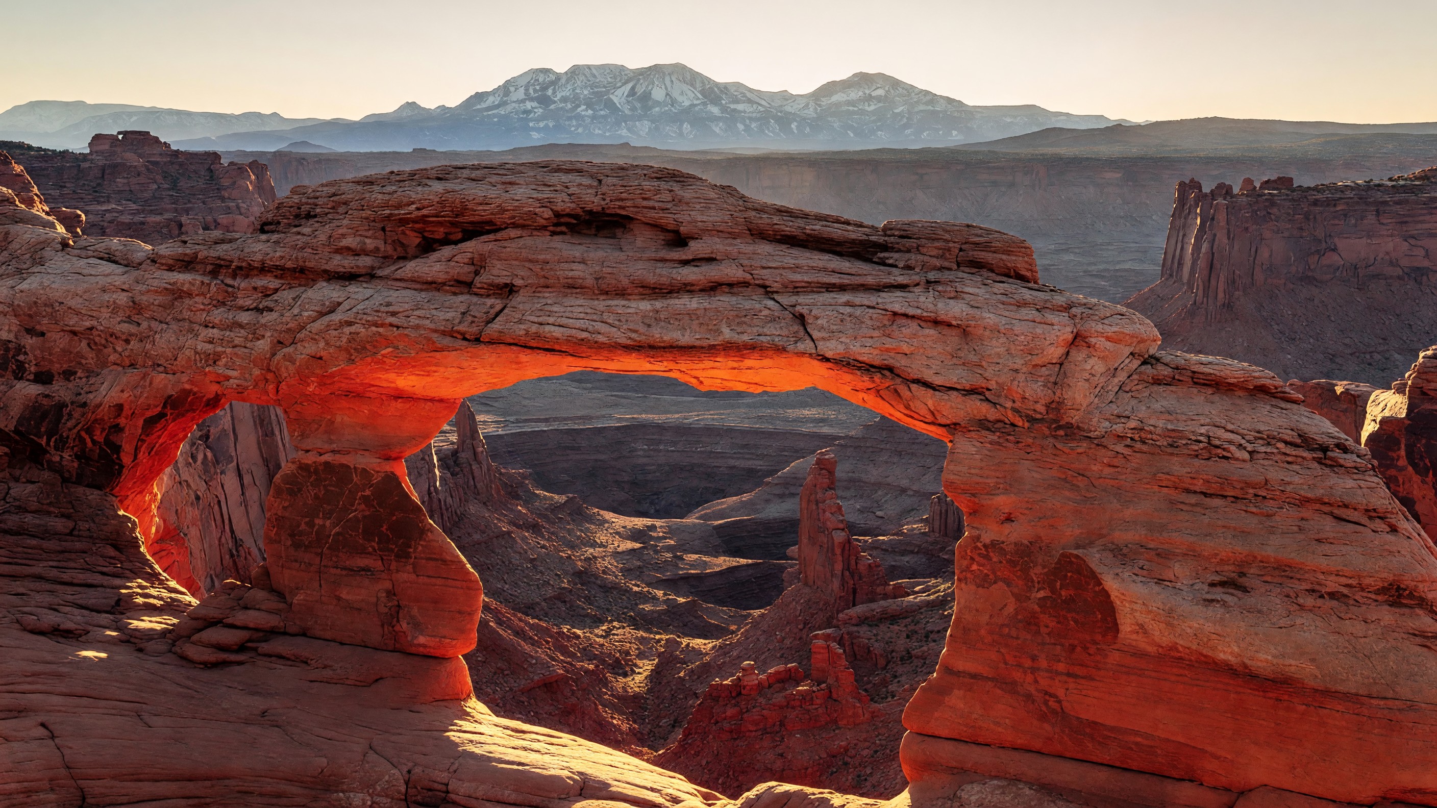
1. Mesa Arch — Canyonlands National Park, Utah
Mesa Arch is routinely cited as the most-photographed sunrise in the entire National Park System, and having stood there for it on three separate occasions, I don’t think that’s hyperbole. The arch itself is a relatively modest sandstone frame at the rim of the Island in the Sky mesa — not enormous, not dramatic from the outside. Then the sun clears the horizon east of the canyon, fires horizontally through the arch frame, and illuminates the underside of the stone in a red-orange glow that lasts roughly four to eight minutes before the angle changes. During those minutes, the arch functions as a portal — canyon depth below, glowing rock above, the La Sal Mountains in the background going from purple shadow to pale blue. It is a genuinely extraordinary convergence of geology and orbital mechanics.
A critical point many visitors get wrong: Mesa Arch is in Canyonlands National Park, specifically the Island in the Sky district. It is not in Arches National Park. The two parks are separate NPS units with separate entrances, located about 32 miles apart. Confusing them is one of the most common itinerary errors for first-time Utah visitors. The Canyonlands National Park Island in the Sky entrance is approximately 35 miles from Moab on UT-313; the trailhead is about 6 miles past the entrance station.
Location and approach: The Mesa Arch trailhead is a signed lot off the Island in the Sky road. The trail is 0.6 miles round trip, flat, on compacted gravel. No elevation gain. Walking time to the arch: 10–12 minutes at a comfortable pace. Arrive 45–60 minutes before sunrise to claim a shooting position; this is one of the most crowded sunrise locations in the West and the good angles fill up fast.
Light direction: The arch faces east-southeast. At summer solstice (late June), sunrise is far enough north that the light enters the arch at a shallower angle — still good, but the red-glow effect is stronger at spring and fall equinox when the sun rises more directly east. Winter solstice sunrise is too far south to fire cleanly through the frame.
Focal lengths: 24–35mm captures arch + canyon context. 50–70mm tightens into the arch frame and compresses the La Sal Mountains into a stronger background element. Both are worth shooting in the first ten minutes.
Accessibility: Paved access road; gravel trail is flat and relatively firm. Most visitors with mobility aids can manage the approach.
Admission: Canyonlands entry fee (covered by America the Beautiful pass).
2. Schwabacher Landing — Grand Teton National Park, Wyoming
Schwabacher Landing is a braided Snake River access point about five miles south of Moose Junction on the Teton Park Road. At sunrise, the river’s still water functions as a mirror for the Teton Range, and the image — jagged granite peaks reflected in a foreground of clear, slow-moving water — is one of the cleanest landscape compositions in American photography. Ansel Adams worked this terrain. The reflection works because the river slows at this particular bend and the peaks are positioned due west, meaning the morning light hits them from behind the camera.
Arrival: 50–60 minutes before sunrise. The dirt access road is about a mile off the highway; low-clearance vehicles handle it fine in dry conditions. In wet conditions, a high-clearance vehicle is helpful. The lot holds perhaps 15 cars; overflow parks along the road shoulder.
Light direction: Morning light falls on the east face of the Tetons from directly behind your shooting position — perfect for reflection photography. At equinox, the peaks are fully lit within 10–15 minutes of sunrise. Summer solstice pushes first light earlier (often before 5:30 a.m. in June) but the angle is slightly more oblique.
Focal lengths: 24–50mm for the wide river bend and full reflection; 70–100mm if you want to isolate specific peaks above the waterline.
Golden hour duration: The useful reflection window is roughly 20–30 minutes from civil sunrise to full sun washing out the subtle tonal contrast in the water. Move quickly.
Accessibility: Accessible from the gravel parking area by walking flat terrain 50–100 meters to the riverbank. Not paved, but passable for most visitors.
3. Oxbow Bend — Grand Teton National Park, Wyoming
Oxbow Bend is the river bend three miles east of Jackson Lake Junction where the Snake River curves in a tight meander below the Tetons, with Mount Moran as the dominant background peak. Where Schwabacher Landing rewards telephoto work and tight reflections, Oxbow Bend rewards wide-angle shooting: the river curve, the willow-lined banks, the peak, and the sky all fit into a 24mm frame without cropping anything important. Great blue herons fish the shallows here regularly; moose wade the margins in early morning. Wildlife and landscape in the same composition is a genuine option on a good morning.
Arrival: 45 minutes before sunrise. The turnout is a signed pull-off on US-89/191 — larger than Schwabacher, can hold 30+ vehicles. It fills on peak summer weekends.
Light direction: Mount Moran faces roughly southeast, which means early morning light hits its face directly. The reflection in the still oxbow water is strongest in the calm minutes before wind rises (typically within the first 30–45 minutes of dawn). By mid-morning, river-surface wind destroys the mirror effect.
Focal lengths: 16–28mm for the full bend composition; 50–70mm for Mount Moran isolation with the river as a foreground element.
Accessibility: Flat pull-off; short walk to the waterline on compacted ground.
Both Schwabacher and Oxbow are covered in more depth in the full Grand Teton National Park visitor guide.
4. Mather Point — Grand Canyon National Park, Arizona
Mather Point is the first major viewpoint most visitors encounter after entering the South Rim — it’s the closest major overlook to the main visitor complex — and at sunrise it is less crowded than you’d expect because most people haven’t yet figured out that dawn is the single best time to see the Canyon from the rim. First light at Mather hits the North Rim and the upper strata of the Kaibab and Toroweap Formations in a progression from pink through orange to warm gold, while the inner gorge below remains in deep purple shadow. The color contrast between lit rim and shadowed floor is one of the Grand Canyon’s most visually dramatic moments.
Arrival: 45 minutes before sunrise. Mather Point parking fills by mid-morning on peak days; at dawn the lot is typically manageable. From the South Rim Visitor Center area, it is a 5-minute walk.
Light direction: The South Rim looks north and northwest across the canyon; sunrise light enters from the east-southeast and sweeps across the North Rim’s face. At summer solstice, sunrise is early (around 5:15 a.m. local time in July) and the angle is steep — the inner canyon loses its shadow depth faster. Fall equinox through winter offers the most dramatic shadow contrast.
Focal lengths: 24–50mm captures the full panoramic sweep; 100–200mm compresses distant North Rim formations into strong telephoto stacks with atmospheric haze as depth cues.
Walking distance: Under 0.5 miles from main visitor parking. Paved surface.
Accessibility: Paved rim trail with accessible viewpoint. Full accessibility notes at nps.gov/grca.
5. Mormon Row — Moulton Barn — Grand Teton National Park, Wyoming
The Moulton Barn on Mormon Row is probably the most-photographed barn in the United States, and the Teton Range behind it is the reason. The homestead dates to the early twentieth century; the barn’s aging wood and rusted metal roof against the Cathedral Group peaks — Grand, Owen, Teewinot — is the kind of human-scale foreground anchor that pure mountain photography often lacks. At sunrise the peaks light while the barn and the sagebrush flat in front of it remain in cool shadow, creating a contrast that is almost impossible to make look bad.
Arrival: 40–50 minutes before sunrise. Mormon Row Road (a dirt lane off Antelope Flats Road, about 2 miles east of Moose Junction) is accessible without 4WD in dry conditions. Arrive early for position; this location sees heavy photography traffic in summer.
Light direction: The barn faces roughly southeast, Tetons due west-northwest. Sunrise light hits the peaks while the barn is in shade — the foreground/background light separation is part of the compositional appeal. The barn enters full sun about 20–30 minutes after the peaks light.
Focal lengths: 50–85mm creates the classic compressed-peaks-behind-barn composition; 24–35mm for a wider environmental frame showing the full sagebrush flat.
Golden hour window: The useful window from peak lighting to flat midday quality is about 30–40 minutes.
Accessibility: Flat gravel road and open field; no formal trail. Accessible with reasonable vehicle clearance.
6. Bear Lake — Rocky Mountain National Park, Colorado
Bear Lake is the heart of Rocky Mountain’s photographic center — the trailhead hub for 10+ miles of trails, and also the single most accessible subalpine lake reflection in the park. At sunrise, Hallett Peak (12,713 feet) reflects in the lake’s calm surface, with the surrounding spruce-fir forest framing the scene. What makes Bear Lake specifically interesting photographically is its high elevation (9,475 feet) combined with short walking distance from parking (0.2 miles, paved loop) — it is one of the highest-elevation lake reflections in the NPS system that requires no serious hiking.
Arrival: 50–60 minutes before sunrise. The Bear Lake Road shuttle system is the standard access method from late May through mid-October; personal vehicles can drive to the Bear Lake lot but it fills extremely early on summer weekends. Check the Rocky Mountain National Park site for current shuttle hours and parking conditions.
Light direction: Hallett Peak faces roughly northeast; it receives direct morning light within 20–30 minutes of sunrise. At summer solstice, the sun rises far enough north that the light hits the peak’s northwest face — a slightly flatter angle but still strong. Equinox sunrise lines up better for direct east-face illumination.
Altitude note: At 9,475 feet, physical exertion feels different than at sea level. Plan slower movement and more water than you think you need, especially on arrival day.
Focal lengths: 24–50mm for the full lake + peak reflection; 85–135mm for compressed peak-and-reflection compositions that de-emphasize the shoreline.
Accessibility: Paved 0.2-mile approach from parking lot; the Bear Lake loop itself is paved and accessible. USGS elevation data confirms lake surface at 9,475 feet — acclimatization consideration for visitors arriving from lower elevations.
7. Tunnel View — Yosemite National Park, California
Tunnel View is widely known as the sunset location at Yosemite — the sweeping valley view from the east portal of the Wawona Tunnel, framing El Capitan on the left, Bridalveil Fall on the right, Half Dome in the distance — and it does deliver extraordinary evening light. What fewer people realize: it works at sunrise too. Eastern morning light enters the valley and hits El Capitan’s broad face while the Valley floor is still in shadow, producing a warm-lit granite wall against deep cool tones below. The direction is reversed from sunset, and the tonal hierarchy inverts, but the composition is equally compelling.
Arrival: 45 minutes before sunrise. The Tunnel View parking area is well-signed at the Wawona Tunnel east portal, accessible from Wawona Road (CA-41). Note that Yosemite Valley has a timed-entry reservation system during peak season — verify current reservation requirements at nps.gov/yose before your visit.
Light direction: El Capitan’s east face lights up within 15–20 minutes of sunrise at equinox. At summer solstice, the sun rises far enough north that first light on El Capitan arrives at a shallower angle and takes longer. Winter sunrise is steep and dramatic.
Focal lengths: 24–35mm for the full valley composition; 70–100mm for compressed El Capitan–Half Dome relationship without the full width.
Golden hour duration: Valley light transitions quickly because the walls create deep shadows that collapse fast once direct sun clears them. The useful gradient window is about 15–25 minutes.
Accessibility: Paved overlook directly adjacent to parking lot. No walking required.
8. Yaki Point — Grand Canyon National Park, Arizona
Yaki Point is the South Rim alternative when Mather Point is too crowded, and in some ways it’s the better sunrise location. It sits roughly 2.5 miles east of Mather along the East Rim Drive, accessible by shuttle bus (Yaki Point is the South Kaibab trailhead and shuttle is required during peak season — no private vehicles allowed). The view encompasses a wider sweep of the inner canyon than Mather, and the slightly more eastward position means the angle of first light on the canyon strata is marginally more dramatic.
Arrival: Plan the shuttle timing carefully — you need to catch an early shuttle from the visitor area to arrive 40–45 minutes before sunrise. The park’s free shuttle runs early during peak season; check the schedule in advance at nps.gov/grca.
Light direction: Similar east-to-southeast sunrise light as Mather but with a slightly different azimuth advantage. The east-facing canyon walls receive first light earlier at Yaki than at Mather.
Focal lengths: 50–200mm telephoto is where Yaki shines — the layered butte formations east of the viewpoint are excellent subjects for compressed telephoto compositions that stack the Kaibab, Toroweap, Coconino, and Hermit strata into distinct color bands.
Walking distance: From the shuttle stop to the main overlook, under 100 meters. The South Kaibab Trail drops from this point if you want to combine a sunrise shoot with an early morning partial descent.
Accessibility: Paved overlook, shuttle accessible.
9. Tipsoo Lake — Mount Rainier National Park, Washington
Tipsoo Lake sits at 5,188 feet on the east side of Chinook Pass, at the edge of a subalpine meadow that in peak wildflower season (typically late July through mid-August) rings the lake with lupine, paintbrush, and bistort. Mount Rainier’s summit rises to 14,410 feet to the west-northwest, and at sunrise the mountain reflects in the lake while the wildflowers provide a foreground that functions as natural color saturation. It is, in good conditions, a technically almost-impossible photograph to ruin.
Wildflower timing: Peak bloom varies by year and snowpack. In most years, late July to mid-August is the reliable window. Early July and late August can both be excellent but are more variable. The USGS and Mount Rainier National Park site typically post wildflower condition updates.
Arrival: 45 minutes before sunrise. Tipsoo Lake is off SR-410 at Chinook Pass — not accessible from the main Paradise/Longmire side of the park. Drive time from the park’s main entrances is 45–60 minutes; plan accordingly. The pullout parking area fills early on peak summer weekends.
Light direction: Rainier faces west-northwest; at sunrise the mountain is backlit from the east, which creates dramatic rim-lighting on the glaciated upper flanks. The lake reflection captures this silhouette-to-backlit transition effectively. This is not the classic fully-lit mountain shot — it’s a different, often more dramatic interpretation.
Focal lengths: 24–50mm for lake + mountain + meadow. 85–135mm for tighter peak reflections that drop the meadow and compress the summit.
Golden hour duration: At this latitude (46.9°N) in summer, golden hour at sunrise lasts 25–35 minutes — longer than desert parks because the sun rises at a shallower angle relative to the horizon.
Accessibility: Flat pullout area adjacent to the lake; no significant walking required for the primary composition. Trail loops around the lake for additional angles.
10. Sunrise Point — Bryce Canyon National Park, Utah
Sunrise Point at Bryce Canyon lives up to its name with a specificity that feels almost contrived: the east-facing overlook catches first light before anywhere else in the amphitheater, and the hoodoos — the park’s dense formations of orange-pink Claron limestone spires — go from dark silhouettes to glowing columns in a color progression that happens in about 15 minutes. The light temperature shift in RAW files from this location during that window is extraordinary.
Arrival: 40–50 minutes before sunrise. The Bryce Canyon entrance is straightforward and the road to Sunrise Point is paved; the lot is a short walk from the overlook rail. The park’s free shuttle serves Sunrise Point during operating season (roughly April through October).
Light direction: Due east-facing. At summer solstice, the sun rises at a steeper angle and the warm color window is compressed — 8–10 minutes of peak orange before it bleaches toward yellow. At fall equinox, the angle is shallower and the warmth lasts 15–20 minutes. Winter sunrise at Bryce, with snow on the hoodoos and low-angle light, is perhaps the most dramatic of all.
Focal lengths: 50–85mm for mid-range hoodoo clusters that show individual spire character; 24–35mm if you want the full amphitheater panorama. A telephoto at 135–200mm compresses distant formation rows into excellent graphic patterns.
Altitude note: Sunrise Point sits at approximately 8,000 feet. Cold mornings are common even in summer. Hand warmers make a material difference for shutter-button dexterity.
Accessibility: Paved overlook, short walk from lot. The paved Rim Trail between Sunrise and Sunset Points is fully accessible. Full detail in the Bryce Canyon National Park guide.
11. Trail Ridge Road — Rocky Mountain National Park, Colorado
Trail Ridge Road climbs to 12,183 feet at its highest paved point, making it the highest continuous paved road in the United States. Shooting sunrise from the alpine tundra section — particularly at the Rock Cut or Forest Canyon overlooks — puts you above the cloud inversion that frequently fills the valleys below on summer mornings. When that happens, the peaks emerge from a sea of cloud and the early light turns the tundra grasses to gold. It is a different category of photograph than any valley-based composition.
Access window: Trail Ridge Road is typically open from late May through mid-October, weather permitting. NPS confirms the road’s current open status at nps.gov/romo. Snow can close the road at any point during the open season.
Arrival: The drive up Trail Ridge Road from the Beaver Meadows entrance takes 35–45 minutes to reach the alpine zone. Factor that into alarm time — you need to be moving before 4:30 a.m. in peak summer (sunrise near 5:40 a.m. at this latitude in June).
Light direction: The orientation of specific overlooks varies. Rock Cut faces generally north and east; Forest Canyon Overlook faces west-southwest over the canyon. For sunrise, Rock Cut is the better primary position; the tundra foreground lights up quickly.
Temperature: Even in July, summit temperatures at dawn can be in the 30s°F (0–5°C) with wind. Dress in layers that go beyond what feels necessary in the parking lot.
Focal lengths: 24–50mm for tundra + cloud inversion compositions; 100–200mm for compressed peak layers when the cloud inversion is present.
Accessibility: Pullouts along Trail Ridge Road are short walks from paved surfaces, but the altitude (12,000+ feet) creates physical limitations independent of mobility considerations.
12. Wonder Lake — Denali National Park, Alaska
Wonder Lake is the iconic Denali reflection shot — the 62-mile-long park road reaches it in full, and the lake’s surface, on a calm morning with no wind, reflects Denali’s 20,310-foot summit at roughly 26 miles’ distance. The mountain fills the sky. Nothing else looks like this.
2026 access reality: The Denali Park Road is currently closed to bus traffic beyond Mile 43 (East Fork bridge area) due to the ongoing Polychrome Pass area road damage. Wonder Lake is at Mile 85. Personal vehicle access beyond the Savage River Check Station (Mile 15) is not permitted under normal circumstances. As of June 2026, Wonder Lake is not accessible by NPS road bus beyond Mile 43. Visitors should confirm current road status directly with NPS at nps.gov/dena before planning a Wonder Lake shoot — road conditions and access can change seasonally.
When the park road is fully open — which does occur in good years — access is via the NPS Camper Bus to Wonder Lake Campground. Campsites at Wonder Lake require advance booking through Recreation.gov and sell out months in advance.
Arrival (when accessible): Wonder Lake campground puts you at the composition’s starting point. Sunrise in June and early July at this latitude (63°N) occurs between approximately 3:30 a.m. and 4:30 a.m. — the sun barely sets in midsummer. At summer solstice, civil twilight begins around 1:00 a.m. and usable shooting light runs almost continuously through the night.
Light direction: Denali is due north of Wonder Lake. At summer solstice sunrise, the sun rises in the northeast and wraps around to light the mountain’s southeast face in a range from pink through gold. The calm-water reflection window depends entirely on wind — Wonder Lake is notorious for mirror-calm conditions one morning and choppy the next. Patience over multiple mornings is the standard strategy.
Focal lengths: 70–135mm brings the summit close while maintaining lake foreground; 200mm isolates the mountain and its reflection.
Altitude note: Wonder Lake sits at approximately 2,090 feet — unusually low for an Alaskan wilderness park. The limiting factor is access, not altitude.
Sunrise vs. Sunset Trade-offs by Park
Not every location on this list is only a sunrise spot. A few practical trade-offs. For dedicated sunset coverage — including Hopi Point, Dante’s View, Dead Horse Point, and eight other Western park locations — see the companion sunset photography guide.
| Location | Sunrise | Sunset |
|---|---|---|
| Mesa Arch | Primary (fires underside of arch from east) | Back-lit arch, no glow effect |
| Schwabacher Landing | Primary (calm water) | Tetons in shadow |
| Oxbow Bend | Primary (Moran face lit) | Good for sky reflections |
| Mather Point | Good | Also good (North Rim lit gold) |
| Mormon Row Barn | Good (peaks lit, barn in shadow) | Better (warm light on barn) |
| Bear Lake | Primary | Good with evening alpenglow |
| Tunnel View | Good (El Cap face lit) | Classic and popular |
| Yaki Point | Primary | Good |
| Tipsoo Lake | Primary (backlit mountain) | Also good (front-lit mountain) |
| Sunrise Point | Primary (east-facing) | Low priority |
| Trail Ridge Road | Primary (cloud inversions) | Excellent also |
| Wonder Lake | Primary | Also excellent |
Gear for National Park Sunrise Photography
Tripod — non-negotiable for blue hour. The 10–20 minutes before civil sunrise, when the sky is luminous but the landscape is dark, requires exposures of 2–15 seconds. No amount of stabilization technology replaces a solid tripod at ISO 400, f/8, and a 4-second exposure.
ND graduated filters. A 2-stop or 3-stop reverse graduated ND is genuinely useful at desert parks (Mesa Arch, Bryce, Grand Canyon) where the horizon glow is the brightest part of the frame and the landscape foreground is very dark. A reverse grad ND is designed specifically for sunrise and sunset compositions where the brightest band is right at the horizon — standard grad NDs place the dark zone too high in the frame.
Remote shutter release. Even with image stabilization, pressing the shutter button introduces vibration. A cable release or wireless remote costs under $30 and eliminates the problem.
Hand warmers. At altitude and in desert cold, battery performance degrades. Hand warmers in jacket pockets extend battery life. Bryce Canyon at 8,000 feet in a July pre-dawn is frequently in the 30s°F. Trail Ridge Road in June can be in the 20s°F.
Extra batteries. Cold drains batteries faster than displayed temperature would suggest. Bring one extra minimum; two is better for all-day shooting.
Headlamp with red-light mode. Essential for pre-dawn approach trails. Red mode preserves your night vision and is less disruptive to other photographers already set up.
Seasonal Sunrise Times: What to Plan For
The range across Western national parks is substantial:
| Location | Summer Solstice Sunrise | Winter Solstice Sunrise |
|---|---|---|
| Denali (63°N) | ~3:30 a.m. | ~10:00 a.m. |
| Mount Rainier (47°N) | ~5:10 a.m. | ~8:10 a.m. |
| Rocky Mountain (40°N) | ~5:40 a.m. | ~7:20 a.m. |
| Grand Teton (43°N) | ~5:30 a.m. | ~7:50 a.m. |
| Yosemite (37°N) | ~5:45 a.m. | ~7:15 a.m. |
| Bryce Canyon (37°N) | ~5:50 a.m. | ~7:20 a.m. |
| Grand Canyon (36°N) | ~5:15 a.m. (Arizona, no DST) | ~7:35 a.m. |
| Canyonlands (38°N) | ~5:45 a.m. | ~7:35 a.m. |
Note: Arizona does not observe Daylight Saving Time (except the Navajo Nation). Sunrise times at Grand Canyon and Canyonlands feel early relative to other states because of this; check local sunrise tables for the specific date of your visit at USGS’ sunrise/sunset calculator or the NPS park page.
Low-Light Camera Settings: A Starting Framework
These are starting points, not prescriptions — your specific camera’s high-ISO behavior, the available light level, and your compositional goals will all modify these.
Blue hour (20+ minutes before sunrise):
- ISO 400–800
- f/8–f/11 (maximize depth of field for wide-angle landscapes)
- Shutter: 5–20 seconds (use mirror lock-up or electronic shutter on mirrorless)
- Tripod required
Civil twilight (5–15 minutes before sunrise):
- ISO 200–400
- f/8
- Shutter: 1–5 seconds
First direct light (sunrise to 10 minutes after):
- ISO 100–200
- f/8–f/11
- Shutter: 1/30s–1/250s depending on how fast light is changing
The single most useful processing decision: shoot RAW. The color temperature shift from pre-dawn blue to golden sunrise happens in about 10°K per minute in the first 20 minutes. JPEG auto white balance averaged over multiple frames misses the subtlety; RAW lets you dial each frame independently in post.
Leave No Trace at Dawn
One thing that doesn’t make the gear lists: dawn quiet carries. In still pre-sunrise air at Mesa Arch, a murmured conversation at normal volume is audible 40 meters away. Tripod legs dragging on rock carry further than you’d expect.
Practical considerations:
- Set up gear before the crowd forms — a head-on tripod-carrier in the dark disrupts 20 photographers already positioned
- Walk gently on any surface that might be cryptobiotic soil crust (dark, lumpy, biological — common at Canyonlands and Arches); off-trail footsteps here cause damage that takes decades to recover
- At Mesa Arch specifically: stay behind the established photography line at the cliff rim — there have been serious accidents when visitors stepped past the anchor point to get a different angle
- Headlamps at full brightness directly into other people’s camera frames are the single most common source of conflict at popular sunrise locations; keep your light low and directed at the ground
Frequently Asked Questions
What time should I arrive for a national park sunrise shoot? At minimum 45 minutes before sunrise for short walks to established overlooks (Mather Point, Tunnel View, Sunrise Point). For locations requiring a longer approach or where position competition is serious (Mesa Arch, Schwabacher Landing), 60 minutes before sunrise is more realistic. Blue-hour light — 20 to 30 minutes before civil sunrise — is often the most photogenic period, and arriving too late misses it entirely.
Do I need a permit or reservation just to photograph at sunrise? Generally no, but you need to pay park entrance fees (or hold an America the Beautiful pass). Some parks with timed-entry or peak-hour reservation systems (Yosemite, Arches historically) have operated early-morning exemptions — arriving before the reservation window opens often bypasses the requirement. Verify current policy at each park’s NPS page before visiting.
What is the best focal length for sunrise landscape photography in national parks? A 24–70mm or 24–105mm zoom covers the majority of compositions on this list. A 70–200mm adds compression capabilities that are useful at Mesa Arch, Bear Lake, and Trail Ridge Road. Wide primes (16–24mm) are useful for foreground-rich compositions at Tipsoo Lake and Bear Lake. A single versatile zoom is more practical than a full lens kit when you’re carrying gear on pre-dawn approach trails.
Is sunrise or sunset better for national park photography? It depends on the specific location. Mesa Arch, Schwabacher Landing, Mather Point, and Tipsoo Lake are definitively better at sunrise due to light direction or reflective conditions. Tunnel View and the Moulton Barn are roughly equal between sunrise and sunset, each offering a different but valid look. The Grand Canyon South Rim is excellent at both. Generally, sunrise crowds are smaller at nearly every location — that alone is often reason enough to prefer it.
How do I photograph a lake reflection without wind destroying the mirror surface? Arrive early (before wind picks up), work quickly, and shoot in bursts — calm windows at alpine and mountain lakes can be as short as 3–5 minutes. A remote shutter release minimizes camera shake from button-pressing at long exposures. At locations like Tipsoo Lake and Wonder Lake, having multiple consecutive mornings is the professional approach; no one can guarantee a calm-water day on a single morning.
What gear is essential for alpine and desert sunrise photography? Tripod, remote shutter release, extra batteries, hand warmers, and a headlamp. In desert environments (Canyonlands, Bryce, Grand Canyon), morning temperatures can drop into the low 40s°F even in July. At alpine locations (Trail Ridge Road, Tipsoo Lake), expect below-freezing conditions on any summer morning. Dress warmer than feels necessary at the trailhead; the 40 minutes of standing still while you wait for light will reveal every gap in your layering.
Resources
- National Park Service — Find a Park — official park pages with current conditions, road status, and fee information
- National Parks Conservation Association — advocacy and park policy context
- USGS National Map — elevation data, topographic maps, sunrise/sunset calculations
- Recreation.gov — campsites, permits, and timed-entry reservations for all parks in this guide