Most national parks give you one thing to chase. Arches has the red rock. Glacier has the ice. Yellowstone has the geothermal weirdness. Olympic gives you three completely different worlds inside a single park boundary — alpine tundra, temperate rainforest, and one of the longest wild Pacific coastlines in the lower 48. The catch is that no road cuts through the park’s center, so visiting all three requires planning separate drives. That friction is also, I’d argue, what keeps Olympic from being overrun. The visitors who make it to all three ecosystems are the ones who showed up prepared.
I’ve now shot Olympic in four different seasons, and the park’s geometry still surprises me. The Olympic Peninsula sits out in the Pacific like an island — ringed by the Strait of Juan de Fuca to the north, Puget Sound to the east, and the open Pacific to the west. US-101 loops around the peninsula’s perimeter, and the park’s major access roads branch off this loop like spokes. You navigate to each ecosystem from the outside. The interior, where Mount Olympus rises to 7,980 feet and carries more glacial ice than any other peak in the contiguous Cascades-adjacent ranges, is roadless wilderness.
The park covers 922,650 acres. Within those acres, annual precipitation at the Hoh Rain Forest averages 140 to 170 inches, while parts of the Sequim Prairie in the rain shadow to the northeast receive less than 17 inches per year. Olympic holds more species of amphibians than any other national park in the Pacific Northwest. Seven rivers begin here. It is, by nearly any ecological measure, one of the most biodiverse protected areas in North America.
The Alpine Zone: Hurricane Ridge
Hurricane Ridge sits at 5,242 feet on a long, south-facing ridge above Port Angeles. The road to the ridge climbs 17 miles from the park’s main visitor center, rising through Douglas fir and silver fir forest before breaking into open subalpine meadows in the final miles. On a clear day — which means any day in July or August before noon, and precious few days in the rest of the year — the view north takes in the Strait of Juan de Fuca, the Gulf Islands and Vancouver Island beyond, and the full irregular sweep of the Olympic peaks to the south and west.
I want to be direct about the current situation at the top: the Hurricane Ridge Day Lodge burned down on May 7, 2023. The structure, a 1950s-era facility housing the visitor center, exhibits, and gift shop, was a total loss. As of this writing, approximately $80 million in federal funding has been allocated toward a rebuild, but no opening timeline has been confirmed. Check nps.gov/olym before your trip for current facility status — the NPS is providing some temporary services on the ridge, but the full visitor center experience is not yet restored.
The ridge itself is unchanged. Wildflowers run from late June through August — lupine and Indian paintbrush thick on the south-facing slopes, avalanche lily pushing up within days of snowmelt near the ridge crest. Black-tailed deer browse the meadow edges in total indifference to cameras, which makes them endlessly useful as foreground subjects. The Hurricane Hill Trail (3.2 miles round trip) follows the ridge west to a viewpoint over the Strait; it’s an easy, rewarding walk with essentially no vertical penalty once you’re already at the top of the access road.
Winter at Hurricane Ridge is one of the Pacific Northwest’s stranger experiences. The ski area here — a small, volunteer-operated facility — is the only downhill ski operation in the national park system. The road is plowed on winter weekends (check the NPS road conditions line, 360-565-3131, before driving up), and if you arrive on a clear January morning with fresh powder on the meadows, you’ll find an alpine environment that feels completely different from the summer version. Bring traction devices for the access road even when it’s plowed; conditions change fast.
Photography notes: Hurricane Ridge is a golden-hour site for me when the weather cooperates. The combination of north-facing strait, south-facing peaks, and high elevation gives you genuine mountain-light on the foreground meadows in the first and last hour. Shoot from the west end of the ridge parking area looking southeast toward the main Olympic peaks in morning light. The problem is that the ridge is often in cloud — check satellite imagery the morning of your planned shoot.
The Temperate Rainforest: Hoh and Quinault
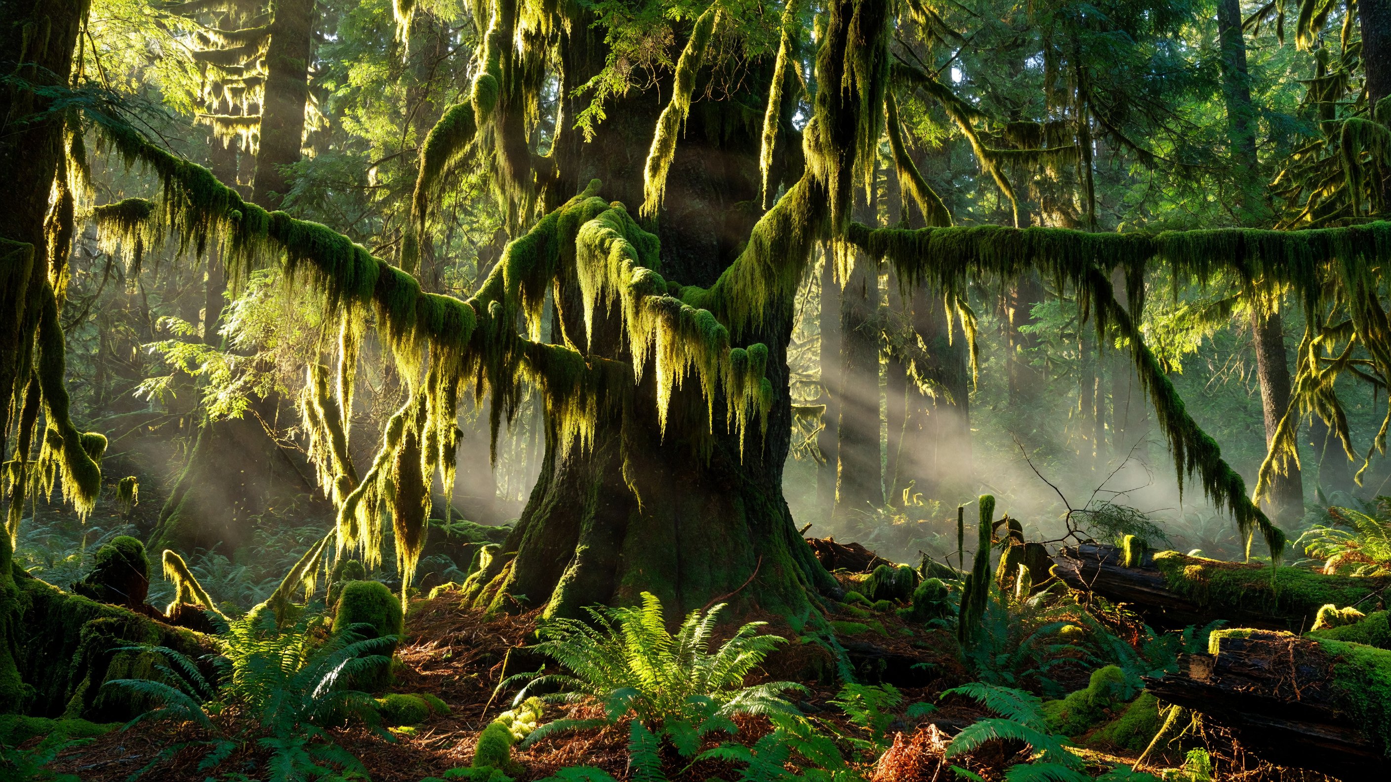
The Hoh Rain Forest is what most people picture when they think of Olympic’s rainforest zone, and the reputation is deserved. The Hoh River Valley sits on the park’s western slope, where moisture-laden Pacific air rises and cools against the mountains, depositing 140 to 170 inches of precipitation annually. The result is a forest density that feels almost architectural — enormous Sitka spruce and western red cedar rising 200 feet from a nurse-log floor, big-leaf maples draped in hanging curtains of club moss so thick they obscure the bark beneath, every horizontal surface colonized by ferns, liverworts, and oxalis.
The Hall of Mosses trail is a 0.8-mile loop near the Hoh Visitor Center. It is short, flat, and paved in its initial section — genuinely accessible for strollers and most mobility devices. I mention the length because first-timers sometimes feel cheated when they see “0.8 miles” and think it means the experience will be brief. It won’t be. The light behaves differently in this forest, and I’ve spent two hours on that loop shooting without feeling like I’d seen it fully. The understory mood changes entirely between overcast and sun — I prefer overcast for the moss textures because direct sun blows out the green gradient.
The Spruce Nature Trail (1.2 miles) extends the experience into old-growth forest along the Hoh River. Elk are frequently visible from this trail, particularly in the open gravel bars along the river. The Hoh River Trail continues 17 miles to the glacier margin on Mount Olympus — a multi-day backpacking route for experienced parties only.
Quinault Rain Forest, accessible from US-101 on the park’s southern edge, offers a different texture of the same ecosystem. The Quinault Valley receives even more precipitation in some years, and the world-record-sized Sitka spruce and western red cedar here (recognized by the American Forests registry) are worth the separate drive. The Quinault Rain Forest Loop (4 miles) circles the lake shore through old growth. Quinault also has the only year-round lodge inside the park’s southern section.
Photography notes: The Hoh is a controlled-light environment — the canopy is so dense that you’re always shooting in forest light, regardless of what’s happening outside. The moss textures at 1–2 inches are extraordinary macro subjects, but the hall’s magic is really in the wide compositions: a 16–35mm at f/8 with the camera on a low tripod, capturing the vertical sweep of spruce columns with a mossy floor. Bring a tripod. You’ll be working at 1/15 second or slower to retain detail in the shadows.
The Pacific Coast
Olympic’s Pacific coastline extends roughly 73 miles — one of the longest stretches of wild, roadless coast remaining in the contiguous United States. The coast is not one continuous experience but a series of access points off US-101, each with its own character.
Ruby Beach is where I take people who’ve never seen this coastline before. The sea stacks — massive basalt formations standing offshore in the surf — are dramatic at any light, but in the last 30 minutes before sunset with incoming tide, they’re genuinely extraordinary. The beach is an easy half-mile walk from the parking area. At low tide, the tide pools at Ruby and along the adjacent offshore rocks hold sea urchins, ochre sea stars, anemones, and chitons. Plan around the tides: the NOAA tide prediction tool for La Push or Destruction Island is essential for this coast. Arriving at high tide on a calm day leaves you standing on a gravel beach watching surf. Arriving at low tide reveals the intertidal world that makes Olympic’s coast notable.
Rialto Beach accesses the coast at the mouth of the Quillayute River north of La Push. The walk north from the Rialto parking area at low tide leads to Hole-in-the-Wall, a sea arch cut through a headland about 1.5 miles from the trailhead. The boulder scramble is not difficult but requires stable footing. At low tide the arch is passable on foot; at high tide it’s submerged. Again: tide tables are not optional.
Second Beach and Third Beach, reached by short forest hikes from US-101, offer a different experience — longer stretches of open sand backed by forest, with sea stacks and offshore rocks at varying distances. Second Beach (0.7 miles from the trailhead) tends to see more foot traffic; Third Beach (1.3 miles) is quieter and rewards the extra distance with a more dramatic stack arrangement.
La Push and the Quileute Tribe: La Push is the community at the mouth of the Quillayute River, adjacent to the park boundary. It is the homeland of the Quileute Tribe, who hold sovereign territorial rights here separate from the national park. The tribal village and marina predate the park’s creation by centuries; the Quileute fished, hunted whales, and maintained permanent villages on this coast long before European contact. Visitors should understand that La Push is not part of Olympic National Park — it is a sovereign tribal community adjacent to the park. For cultural and historical depth, the Quileute Tribe’s own website is the appropriate resource; visiting tribal lands requires respect for the community’s guidelines. The park’s relationship with the Quileute, Hoh, Quinault, and Makah Nations is ongoing — these tribes retain treaty rights and cultural connections to park lands.
Photography notes: Ruby Beach is my first stop on any photo-specific Olympic trip. Low tide in the 30 minutes before sunset is the technical ideal — warm light on the sea stacks, tide pools in the foreground, no direct sun blowing out the water surface. Plan to arrive 90 minutes before sunset so you can scout the beach at low tide before the light arrives. The stacks photograph best from the southern end of the beach looking northwest.
Sol Duc Hot Springs and Lake Crescent
The park’s northwestern section — accessible from US-101 west of Port Angeles — contains two destinations that sit outside the three-ecosystem framework but deserve their own plans.
Sol Duc Hot Springs Resort is the only developed hot springs facility inside the park. Three soaking pools fed by natural mineral springs sit at the end of Sol Duc Road, operated by the resort under a park concession agreement. The springs are genuinely therapeutic after a day of hiking, and the surrounding old-growth forest makes the setting exceptional. The resort operates seasonally — typically late March through late October — and advance reservations are advisable for both the pools and the lodge. Call the resort directly to confirm current season dates before your trip.
The Sol Duc Falls hike is a 1.6-mile round trip on a forest path through old-growth Sitka spruce and western hemlock to a waterfall that drops into a narrow bedrock canyon split by a central rock pillar. It is among the most photographed waterfalls in Washington. The forest itself, old-growth with substantial canopy closure, is worth the walk even if the falls were less dramatic. The trailhead is at the end of Sol Duc Road, adjacent to the resort.
Lake Crescent sits on the park’s northern edge along US-101, a deep glacially carved lake of extraordinary clarity. The cold water (typically 30–50 feet of visibility in calm conditions) and depth (400 feet at maximum) give it a blue-green color that photographs don’t quite capture. Lake Crescent Lodge is a historic property dating to 1916, operating under a park concession for lodging, dining, and boat rentals. The lodge operates seasonally — generally late April through late October — and is worth a dinner reservation even if you’re not staying there. The view of the lake from the lodge’s porch at dusk is one of those Olympic experiences that’s hard to improve upon.
The Marymere Falls Trail (1.8 miles round trip) leaves from the Storm King Ranger Station near Lake Crescent Lodge, crossing Barnes Creek twice before reaching a 90-foot falls in a mossy canyon. Easy, rewarding, and accessible to most hikers.
Planning Your Visit: Access and Logistics
No road crosses the Olympic Peninsula’s interior. This is the central planning fact for any Olympic trip, and it deserves emphasis: the Hoh Rain Forest, Hurricane Ridge, the Pacific Coast, and Sol Duc are on different sides of the park and require different drives. From Port Angeles, Hurricane Ridge is 17 miles south. The Hoh Rain Forest is roughly 90 miles west via US-101. Ruby Beach is approximately 95 miles from Port Angeles. These are not short repositions — a full three-ecosystem itinerary requires at least two full days of driving time in addition to time on the ground.
Port Angeles is the primary gateway for Hurricane Ridge and the northern corridor. The city has lodging, gear shops, and the Olympic National Park Visitor Center (operated separately from the hurricane ridge facilities). Forks is the gateway for the Hoh Rain Forest and La Push coast — a small timber town 90 miles west of Port Angeles. Quinault anchors the southern entrance and Quinault Rain Forest access.
Entrance fees and passes: Olympic is a fee-required park. America the Beautiful passes are honored here and cover the entire peninsula. Some specific campgrounds and facilities require additional reservations through Recreation.gov.
Road conditions: Mountain road conditions on the Olympic Peninsula change rapidly. The NPS road and weather line (360-565-3131) is the fastest way to confirm Hurricane Ridge Road status, especially in shoulder seasons. WSDOT’s 511 system covers US-101 conditions for the perimeter loop.
Accessibility: The Hall of Mosses at Hoh is the most accessible significant trail in the park — relatively flat, short, and partially paved. Hurricane Ridge’s main viewpoint area is accessible via the parking area without a significant hike. The park’s accessibility page at nps.gov/olym has current details on which facilities and trails meet accessibility standards.
For a Pacific Northwest parks road trip, Mount Rainier National Park is four to five hours southeast of Port Angeles and pairs naturally with an Olympic visit — the wildflower timing in July and August aligns. Crater Lake National Park is a longer drive south into Oregon but rounds out a full Pacific Northwest circuit.
The National Park Conservation Association maintains an active advocacy presence for Olympic, including coverage of the Hurricane Ridge rebuild planning and the coastal wilderness designation’s long-term management.
Frequently Asked Questions
What happened to the Hurricane Ridge Visitor Center? The Hurricane Ridge Day Lodge burned down on May 7, 2023. The 1950s-era structure that housed exhibits, a gift shop, and interpretive programs was a total loss. Congress allocated approximately $80 million for rebuild and temporary facilities in late 2023, but no timeline for a permanent replacement has been confirmed. Check nps.gov/olym for current facility status before your visit — some temporary visitor services are available on the ridge.
How many days do I need to see all three ecosystems? A realistic minimum for all three is three full days: one day for Hurricane Ridge and Port Angeles, one day for the Hoh Rain Forest and Sol Duc or Lake Crescent, one day for the Pacific coast. A two-day visit requires aggressive scheduling and will feel rushed. Five days allows for hiking deeper into each zone and adjusting for weather.
Can I drive from the rainforest to the coast in one day? Yes, but the drive from Hoh Rain Forest to Ruby Beach on US-101 is about 25 miles and takes roughly 45 minutes under good conditions. The coast and rainforest are the two most logistically compatible zones for a single-day visit because they share the western side of the peninsula.
When is the best time to visit Olympic? July and August offer the most reliable clear weather across all three zones — Hurricane Ridge meadows are in peak wildflower bloom, the rainforest is lush, and the coast is accessible. These months also bring the highest crowds and the need to arrive early at popular trailheads. Late September into October is my personal preference — fewer people, dramatic light, and the first storms of the season produce compelling coastal conditions. The park is open year-round, but some roads and facilities close October through May.
Are there bears in Olympic National Park? Yes. Black bears are present throughout the park, particularly in the rainforest zones and on trails in berry season (late summer). Bear canisters or bear boxes are required for overnight trips in the backcountry. Day visitors should practice standard food storage (no food left in cars in trailhead lots). Bear spray is advisable for backcountry travel; encounters on day trails are infrequent but not unknown.
Is Olympic National Park worth visiting in winter? For specific winter experiences — Hurricane Ridge skiing, stormy coastal photography, Quinault old growth without crowds — yes, absolutely. For a general visit expecting the full park experience, winter requires significant planning and some flexibility around road and facility closures. The Hoh Rain Forest is open year-round and is actually excellent in winter: quieter, moodier, and the moss more intensely green against grey light. For how Olympic’s winter stacks up against other parks, see our best national parks for winter visits guide.
Where is La Push and can I access it from the park? La Push is the Quileute tribal community at the mouth of the Quillayute River, approximately 14 miles west of Forks on WA-110. Rialto Beach and Second Beach are nearby but accessed via park roads, not through the tribal community. La Push has a marina, a small tribal resort, and the coastal access road passes through the community — visitors should treat it with the same respect as any other sovereign tribal territory.