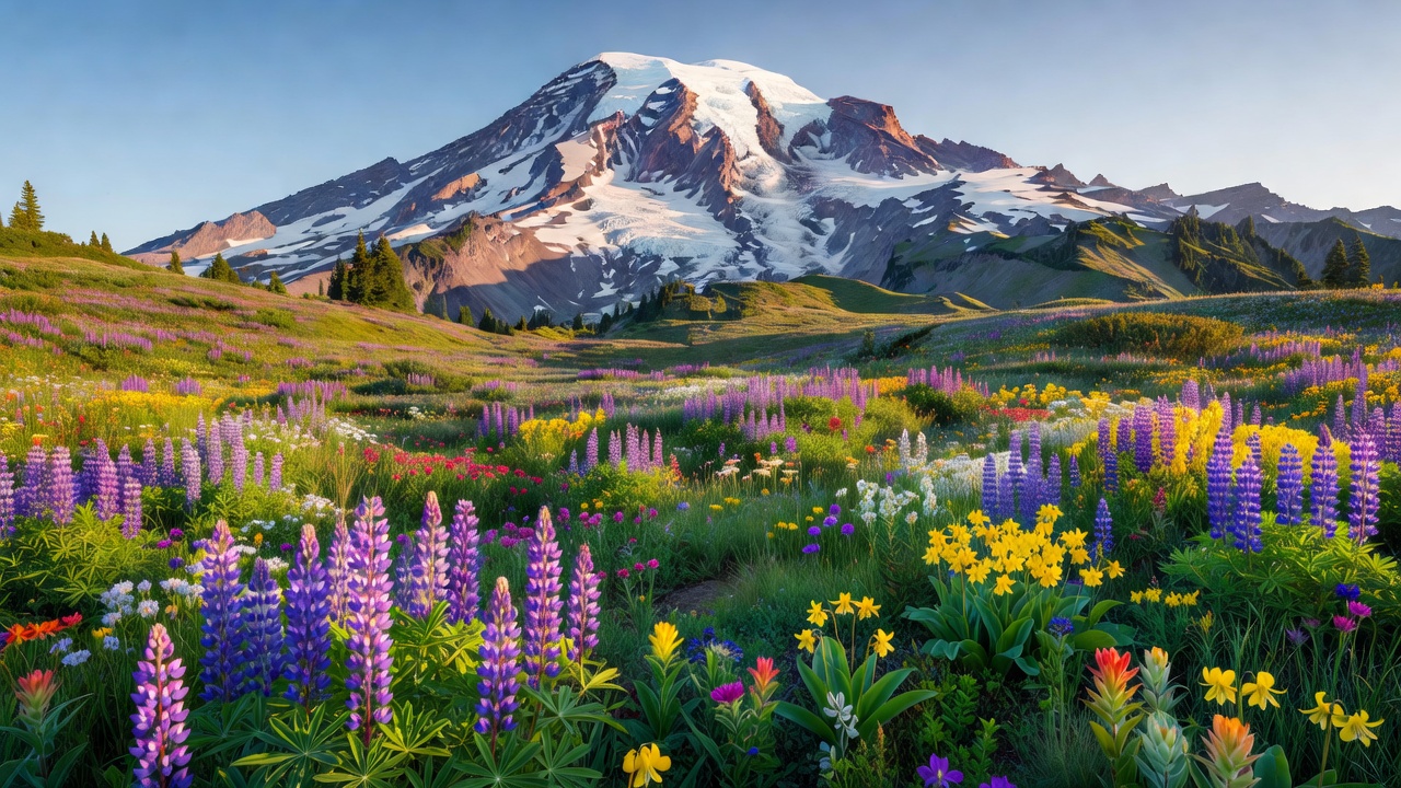
There’s a specific moment that happens on the drive to Paradise when the forest breaks and the mountain fills your entire windshield. You’re at roughly 5,000 feet, the trees haven’t quite given out yet, and suddenly there is nothing in front of you except glacier and sky — 14,410 feet of active stratovolcano going straight up at a scale that feels architecturally implausible. I’ve driven that road maybe a dozen times and it still does something to my heartbeat.
Mount Rainier is the most heavily glaciated peak in the contiguous United States. Twenty-eight named glaciers cover its flanks across roughly 30 square miles of glacial ice, more than all other Cascades volcanoes combined. The park that surrounds it — about 236,381 acres of old-growth forest, river valleys, and subalpine meadow — is one of America’s older national parks, established in 1899. And the wildflower meadows above the Paradise and Sunrise visitor areas in late July and August produce a display of lupine, paintbrush, bistort, and avalanche lily that is legitimately among the best in North America. Not the best in the Northwest, not great for a mountain park — among the best on the continent.
This is also, technically, an active volcano. The USGS rates it as the most dangerous volcano in the Cascades not because of eruption risk in the immediate term, but because of what happens if it does erupt: lahars — volcanic mudflows — would travel down the river valleys at speed, and the surrounding communities have evacuation plans in place. The mountain is monitored continuously by the USGS Cascades Volcano Observatory. This doesn’t make visiting Rainier a hazardous activity; it’s context worth knowing.
2026 Entry: No Reservation Required
One practical piece of planning news: timed-entry vehicle reservations are not required at Mount Rainier in 2026. A pilot program ran during the 2024 and 2025 peak seasons, splitting the park into a Paradise Corridor and a Sunrise Corridor, with timed vehicle reservations required during busy morning windows. That pilot has not been extended for 2026. The park is currently using parking management strategies to handle capacity rather than entry reservations.
This means you can show up without a pre-booked reservation slot. That said, Paradise on a clear summer weekend is still very busy — arriving before 10:00 AM or after 2:30 PM reduces the chance of finding Paradise’s parking lot full. Check nps.gov/mora before your trip; reservation requirements have changed year to year and could change again.
The park entrance fee in 2026 is $30 per vehicle (7-day pass), $25 per motorcycle, or $15 per person on foot or bicycle. America the Beautiful annual pass holders enter free. The park has gone cashless at entrance stations — if you need to pay with cash, purchase a pass at a partner retailer before arriving.
Paradise: The Mountain’s South Face
The Paradise area, on Rainier’s south side at roughly 5,400 feet, is where most visitors experience the park. The name has stuck since the 1880s when a rancher’s daughter — or, in other accounts, a pioneer woman — reportedly exclaimed it on first seeing the meadows. It holds up.
The Henry M. Jackson Memorial Visitor Center at Paradise is the park’s primary interpretive hub, with exhibits on the mountain’s volcanic geology, glacier science, and climbing history. Rangers provide current trail conditions and, in summer, weather forecasts that are worth taking seriously given how fast conditions change on an active volcano.
The Skyline Trail
The Skyline Trail is the park’s single best introductory hike: a 5.5-mile loop from the Paradise parking area that climbs through the upper subalpine meadows to Panorama Point at roughly 6,800 feet. From Panorama Point you are at glacier’s edge — close enough to see crevasses and hear the mountain moving on a quiet afternoon. The route passes through the densest wildflower meadows in the park during peak bloom. Round-trip elevation gain is approximately 1,700 feet.
The trail is moderately strenuous — the upper section has significant steepness — but it’s not technical. It can be done in 3–4 hours by reasonably fit hikers. The key is timing: mid-July through mid-August is peak wildflower season at Paradise. In a heavy snow year, the meadows may not clear until early August; call the visitor center in mid-July to get current conditions rather than guessing from last year’s photos.
Paradise Inn and Overnight Options
Paradise Inn is the only lodging inside the park near the Paradise area. The 1917 historic lodge, built from old-growth logs salvaged from a blowdown, sits at 5,400 feet. It’s open from mid-May through mid-October approximately — the exact dates vary by year and snowpack. Rooms book fast; summer reservations often sell out months in advance. If you want to stay there, book as early as possible through the park’s lodging concessionaire. The combination of staying at elevation, walking into the meadows at first light before day-trippers arrive, and watching the alpenglow hit the summit from the inn’s porch at dusk is genuinely irreplaceable.
The Cougar Rock Campground (near the Nisqually entrance on the park’s south side) is the closest campground to Paradise and operates on a reservation system through Recreation.gov. Longmire, about 11 miles below Paradise on the southwest road, has the park’s year-round ranger station and a small museum.
Sunrise: Highest Paved Road in Washington
The Sunrise area, at 6,400 feet on the mountain’s northeast flank, is the highest point in Washington State accessible by paved road. The drive up from the White River valley is scenic in a different way from the Paradise approach — more austere, with the forest giving way to open subalpine terrain earlier and the views east across the Cascades toward Mount Adams and (on clear days) Mount Baker adding a sense of open plateau.
The Emmons Vista overlook, a short walk from the Sunrise visitor area, looks directly at the Emmons Glacier — the largest glacier by surface area in the contiguous United States — and the summit above it. The perspective on the mountain from Sunrise is more architectural than from Paradise; you see the full northeast face at once rather than looking up the long southern flank.
Sunrise is typically accessible from early July through early October, depending on snowpack on the road. It’s usually less crowded than Paradise on weekday mornings and tends to get better early-morning photography light.
Mount Fremont Lookout Trail
The Mount Fremont Lookout is the signature day hike at Sunrise: 5.7 miles round-trip with about 900 feet of gain, finishing at a historic fire lookout tower with 360-degree views. The route passes through open subalpine meadows with wildflower displays that rival Paradise in peak season. The trail starts from the Sunrise parking area. This is my standard recommendation for photographers who want Rainier summit views without the crowds of the Skyline Trail.
Ohanapecosh: Old-Growth Rainforest
The Ohanapecosh area, in the park’s southeast corner at about 2,000 feet elevation, is a different ecosystem entirely: old-growth temperate rainforest watered by the Ohanapecosh River, with Douglas fir, western red cedar, and Sitka spruce at scales that remind you the Pacific Northwest is not done being extraordinary.
The Grove of the Patriarchs is the park’s most impressive old-growth stand — a short 1.5-mile loop across a suspension footbridge to an island in the Ohanapecosh River where some of the trees are over 1,000 years old. The cedar and fir here reach trunk diameters of 25–35 feet. The loop is mostly flat, partially accessible, and takes about an hour at a relaxed pace.
Silver Falls is another short hike near Ohanapecosh — a 3-mile loop along the river to a waterfall, with old-growth forest throughout. The combination of the two hikes makes Ohanapecosh a worthwhile half-day stop if you’re driving the park’s southeast road.
The Ohanapecosh Campground is one of the park’s largest, operating summer through early fall on reservations through Recreation.gov.
Carbon River and Mowich Lake: The Wet Northwest Corner
The park’s northwest corner — the Carbon River area and Mowich Lake — gets a fraction of Paradise’s visitation and rewards that relative obscurity. The Carbon River valley receives over 140 inches of precipitation annually, making it one of the few inland temperate rainforests in the lower 48. The trail along Carbon River to the Carbon Glacier terminus passes through old-growth rainforest almost incomparable in the continental United States — the glacier itself descends to about 3,600 feet, the lowest elevation of any glacier in the lower 48.
The Carbon River entrance road has been closed to vehicles since flooding damage; access is on foot or by bicycle from the park boundary. Plan for approximately 4 miles of unpaved trail to reach the glacier terminus.
Mowich Lake, reached by unpaved road from the northwest, is the park’s largest lake and the trailhead for Spray Park — a high subalpine basin with wildflower meadows and close views of Rainier’s glacier-laden northwest face. The Spray Park hike is about 8 miles round-trip with 1,600 feet of gain. Mowich Lake Campground is walk-in only (no vehicle camping at lakeside) and one of the quieter overnight spots in the park.
The Wonderland Trail
The Wonderland Trail circles Mount Rainier completely — 93 miles through every major ecosystem in the park, from lowland old-growth to subalpine meadow to glacial moraine. It is one of the classic long-distance backpacking routes in North America. The full circuit typically takes 10–14 days and requires wilderness camping permits.
The permit system for the Wonderland Trail is competitive. Permits release through Recreation.gov in mid-spring for the summer season, and the most popular itineraries — particularly the high-route sections and Paradise-area camps — fill within hours of release. Plan your dates before the permit window opens, have your campsite preferences ranked, and be ready to act quickly.
If completing the full loop is not in your plans, day hiking sections of the Wonderland from trailheads at Paradise, Sunrise, or Mowich Lake captures the trail’s character without requiring a multi-day commitment. The section from Paradise to Indian Henry’s Hunting Ground — a high backcountry meadow with an old patrol cabin and direct Rainier views — is particularly good as a day hike or two-day overnight.
Summit Climbing: What It Actually Requires
Thousands of climbers attempt to summit Mount Rainier each year. The mountain earns its reputation: the gain from Paradise to the summit is over 9,000 feet, and the technical demands of high-altitude glacier travel claim a significant share of attempts before they reach the top.
The standard route is Disappointment Cleaver (DC Route), which gains the summit via the southeast face. From Camp Muir (at 10,188 feet, reachable as a strenuous day hike or the first overnight on a summit attempt) the route climbs through heavily crevassed glacier terrain to the crater rim. The round-trip from Paradise is roughly 16–18 miles with that 9,000+ feet of gain.
This is a technical mountaineering route requiring crampons, ice axe, rope teams, crevasse rescue training, and high-altitude acclimatization. Conditions on the DC Route change rapidly — crevasses open through the season, weather windows on the summit can close in hours, and the altitude affects fitness and judgment in ways that lowland training doesn’t fully prepare you for. The park requires all climbers to hold a climbing registration permit ($82 per person) plus a wilderness permit for any overnight camping en route.
Rainier Mountaineering Inc. (RMI), Alpine Ascents International, and a few other NPS-permitted guide services operate guided summit programs with multi-day training components. For anyone without prior high-altitude glacier mountaineering experience, guided is the appropriate approach. Over twenty different routes exist on the mountain; Disappointment Cleaver is the most trafficked but not the only option for experienced climbers.
Summit conditions and current climbing route status are posted at nps.gov/mora.
Wildflower Peak: A Narrow Window
The wildflower display at Paradise and Sunrise has a narrower peak than visitors sometimes expect. The meadows are blanketed in snow until late June or early July most years — Rainier’s snowpack is substantial and lingers. The flowers emerge as the snow retreats and are typically at maximum intensity from mid-July through mid-August at Paradise and somewhat similar timing at Sunrise.
In a low-snow year, the bloom can start in early July at Paradise. In a heavy snow year, it may not peak until the first week of August. A single phone call to the Paradise visitor center in mid-July — or a check of the current conditions page on nps.gov/mora — is worth more than any prediction made months in advance.
By early September, the meadow palette shifts from bloom-color to the russet and gold of late-season seed heads — still beautiful, but a different experience.
Photography
Mount Rainier offers serious photographic opportunities at both the obvious and less-obvious spots.
Reflection Lakes — a series of small lakes on the road between Longmire and Paradise on the park’s south side — produce morning mirror reflections of the summit that are among the most photographed images in the Northwest. The best conditions require calm winds, no cloud cover obscuring the summit, and arriving at or before first light. I’ve driven down from Paradise to be at Reflection Lakes for a 5:00 AM sunrise in late July. The light is worth it. Arrive early enough to park; the small pullout fills quickly.
Sunrise Ridge at dawn, when alpenglow hits the northeast face and the Emmons Glacier goes orange-pink before sunrise, is one of the best high-altitude alpenglow subjects in the country. The Emmons Vista overlook is the standard shot; getting there before sunrise requires driving up the night before and sleeping at White River Campground, or arriving at Sunrise well before dawn on a clear day.
Tipsoo Lake, near Chinook Pass on Highway 410 just outside the park’s eastern boundary, is a subalpine lake surrounded by wildflower meadows with a classic Rainier reflection. It’s not technically inside the park, but it’s a 10-minute drive from the White River entrance and one of the most compositionally complete Rainier scenes available — mountain, foreground color, water reflection. Peak wildflower timing here roughly matches Sunrise, mid-July through early August.
For serious landscape work, a polarizer is useful in open conditions. A wide-angle lens in the 14–24mm equivalent range handles the summit scale best from most viewpoints; the Panorama Point section of the Skyline Trail is the one place where you want a moderate telephoto to frame glacier details.
Accessibility
The Paradise area has paved walking paths and accessible restrooms near the Jackson Visitor Center. The lower portions of the Skyline Trail are paved and accessible; the upper sections are not. The Sunrise visitor area has accessible facilities and the Emmons Vista viewpoint short walk is accessible. The Grove of the Patriarchs at Ohanapecosh is partially accessible — the main loop is on crushed gravel with a suspension bridge crossing that is manageable for most mobility devices, though it may be challenging at the suspension bridge span.
For detailed accessibility information by trail, the NPS accessibility guide for Mount Rainier is at nps.gov/mora/planyourvisit/accessibility.htm.
Seasonal Overview
Summer (late June – mid-October) is peak season. Paradise road from Longmire is typically fully open by late June. Sunrise opens in early July when the road clears. Most trails are snow-free at lower elevations from late June; subalpine trails above 6,000 feet clear from mid-July. Weather on the mountain can change in hours — morning clear, afternoon clouds or thunderstorms, especially in August. Always carry rain gear and layers regardless of the morning forecast.
Winter access is limited to the Longmire-to-Paradise road on the southwest side (typically kept plowed and open, weather permitting). Sunrise is closed. The Carbon River and Mowich Lake roads are inaccessible. Winter brings significant snowfall — Paradise averages over 50 feet annually — and the mountain is a destination for backcountry skiing and snowshoeing, but it requires appropriate gear, experience, and avalanche awareness.
Spring (April–June) is highly variable. The road to Paradise can have closures after storms. Snow lingers on meadow trails. Wildlife is active in the lower valleys.
Fall (mid-August through mid-October) is an underrated window: the crowds drop, the meadow colors shift to rust and gold, and clear September days can produce exceptional photography conditions. By late October, winter weather is possible at any time.
Volcanic Hazard Awareness
Mount Rainier is the most closely monitored volcano in the Cascades. The primary hazard is not eruption itself — the mountain has been volcanically quiet — but lahars: volcanic mudflows that can be triggered by eruption, earthquake, or sudden glacial destabilization. Lahars from Rainier would travel down the Nisqually, Puyallup, Carbon, and White River valleys at speeds up to 50 mph. The surrounding communities — Orting, Enumclaw, and others — have detailed evacuation plans.
For visitors in the park, the NPS provides lahar evacuation route signage in the lower valleys and at developed areas. Familiarize yourself with the nearest evacuation route signs at whatever trailhead or campground you’re using. The USGS Cascades Volcano Observatory publishes current monitoring data, eruption history, and hazard assessments for Mount Rainier.
Frequently Asked Questions
When is the best time to visit for wildflowers? Mid-July through mid-August is peak wildflower season at both Paradise and Sunrise. The exact peak varies by snow year — in a heavy-snow year, peak bloom can shift to early August. A call to the Paradise visitor center in mid-July gives you the most reliable current conditions.
Do I need a reservation to enter the park in 2026? No. Timed-entry vehicle reservations are not required at Mount Rainier in 2026. The Paradise and Sunrise Corridor pilot program that operated in 2024 and 2025 was not extended. You still need to pay the entrance fee ($30/vehicle, 7-day pass). Check nps.gov/mora before your trip — reservation requirements can change between seasons.
What is the best hike at Paradise? The Skyline Trail — a 5.5-mile loop with about 1,700 feet of gain — is the standard answer and earns it. Panorama Point at roughly 6,800 feet puts you at glacier’s edge with full summit views. For something shorter, the first mile of the Skyline Trail to the meadow benches above the visitor center delivers most of the wildflower experience.
Can I hike to the summit without a guide? Yes, with the appropriate experience. Mount Rainier’s standard Disappointment Cleaver route requires crampons, ice axe, rope team travel, and crevasse rescue skills. A climbing registration permit ($82/person) is required. Most people without prior high-altitude glacier mountaineering experience should go with a licensed guide service — the combination of altitude, crevasse terrain, and rapidly changing weather on Rainier claims a significant share of attempts.
Is Paradise Inn worth staying at? Yes, unreservedly — if you can get a reservation. The 1917 historic lodge at 5,400 feet lets you walk into the meadows at first light before day visitors arrive, which is categorically different from a same-day drive-up visit. Book as far in advance as possible through the park’s lodging concessionaire.
How do I get there from Seattle? The Nisqually entrance (primary gate, southwest side) is about 83 miles from Seattle — roughly 90 minutes in normal traffic on I-5 south and then Highway 7 and 706 east. The Sunrise entrance is reached via Highway 410 from the northeast, about 100 miles from Seattle. Neither route is particularly fast — the mountain roads are twisty once you leave the lowland highways.
What’s the deal with parking? Paradise parking fills on clear summer weekends, often by 9–10 AM. Arriving before 8 AM or after 3 PM gives you the best chance of finding a spot. Overflow areas exist but are limited. Sunrise parking is smaller but typically less congested on weekday mornings. The NPS recommends arriving before 10 AM or after 2:30 PM at both areas to reduce parking and congestion delays.
Official park information, alerts, and current road/trail conditions: nps.gov/mora. Campground and wilderness permit reservations: Recreation.gov. Volcanic monitoring and hazard data: USGS Cascades Volcano Observatory. Conservation advocacy and park news: National Parks Conservation Association. Washington State highway conditions (road approach): WSDOT.
For Pacific Northwest planning, our guide to Olympic National Park covers three distinct ecosystems within a single park — temperate rainforest, alpine, and wild Pacific coast — about four hours west of the Nisqually entrance.