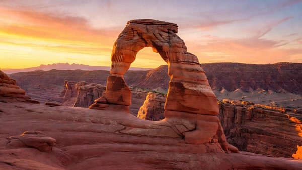
The first thing you need to know about visiting Denali in 2026 is that the park road you may have read about in older guides — the one that winds 92 miles through open tundra past Polychrome Pass, Toklat River, Eielson Visitor Center, and Wonder Lake — is not fully accessible. It hasn’t been since August 2021, when the Pretty Rocks Landslide permanently altered the planning reality for everyone who comes here. Before you book flights to Anchorage or reserve a campsite, this is the one fact that changes everything else.
That said: what remains accessible is still extraordinary. Denali is 6 million acres of Alaskan wilderness — the national park plus the surrounding preserve covers a swath of interior Alaska larger than the entire state of New Hampshire. North America’s highest peak, at 20,310 feet, dominates the skyline on clear days from the entrance area. Grizzly bears, moose, caribou, Dall sheep, and wolves move through the landscape in numbers that would seem implausible if you hadn’t seen them yourself. And the bus-based access model that defines this park remains intact, operating into the accessible western stretches of the road and delivering wildlife encounters that most North American parks cannot match.
This guide covers what you can actually do in 2026, not what the road looked like in 2019.
The Pretty Rocks Landslide: What Every Visitor Needs to Know
In August 2021, a section of the Denali Park Road near Mile 45 at the Pretty Rocks formation began failing. The road crosses an ice-rich permafrost zone, and as that permafrost thaws — accelerated by changing temperature patterns in interior Alaska — the ground beneath the road has subsided and shifted in ways that make road travel beyond the affected area impossible. The failure is not a single dramatic collapse but an ongoing, slow-moving geological process that engineers cannot simply fill or patch their way around.
As of June 2026, the park road is open to bus traffic only as far as Mile 43 at the East Fork Bridge. The road beyond that point is closed, and the closure is expected to remain in place through summer 2026. Eielson Visitor Center, at Mile 66, is closed. Wonder Lake Campground, at Mile 85, is closed.
The NPS and the State of Alaska have been working on the Polychrome Area Improvements project, which involves constructing a new bridge and road alignment that bypasses the landslide zone. This is a major engineering undertaking in a remote location with a short construction season, and the project timeline has extended beyond earlier estimates. Check nps.gov/dena directly for any updates before your trip — the situation can and does change season to season.
The practical effect: visitors in 2026 can access approximately the eastern half of the accessible road corridor, reaching the open tundra and river crossings around Toklat River at Mile 53 on good seasons, but not the dramatic high country beyond. The road’s most iconic destinations — the Polychrome overlooks, Eielson’s mountain views, Wonder Lake’s reflection photography — remain out of reach until the bypass project is complete.
I want to be direct about this because I have watched too many people arrive at the Denali Visitor Center without knowing it, then spend half a day recalibrating their expectations. Plan for what the park currently offers. It’s still magnificent.
What the Park Road Offers Now: Miles 0–43
Even capped at Mile 43, the Denali Park Road delivers access to terrain and wildlife that would be the crown jewel of nearly any other park in the country. Here is what you can reach:
Miles 0–15: Entrance Corridor (Private Vehicles Allowed)
The first 15 miles of the park road have always been open to private vehicles, and that remains true. The Denali Visitor Center is near Mile 1, and it is an excellent first stop — the exhibits on the park’s geology, wildlife, and the history of the road are genuinely useful for first-time visitors. The Savage River Loop Trail at Mile 15 is a flat, 2-mile loop through open tundra at the transition from boreal forest to alpine terrain, with mountain views on clear days. This is also the outer limit for private vehicles before the road narrows and the bus-only rule takes effect.
The Mountain Vista Trail at Mile 12.5 is worth the stop even if you’re driving the private-vehicle section and not continuing by bus. The trail crosses tundra ridges with sightlines that, on a clear day, include Denali itself rising over the lowland forest to the southwest.
Miles 15–43: Bus Access into Open Tundra
Beyond Savage River, private vehicles cannot continue. This is not a 2021 landslide change — it has been the rule since the 1970s, and it is the single policy most responsible for Denali’s exceptional wildlife viewing. With no private vehicle traffic in the backcountry road corridor, the tundra along the road functions more like a wildlife sanctuary than a highway. Animals approach the road without the wariness that vehicle-heavy parks produce.
Transit buses and narrated tour buses, operated by the Doyon/Aramark Joint Venture under an NPS concession, run from the bus depot near the Visitor Center into the backcountry road as far as conditions permit. In 2026, that means service to the East Fork area in the Mile 40–43 range. Toklat River, at Mile 53, has historically been one of the most productive wildlife-viewing areas on the road — grizzly bears are commonly spotted on the gravel bars and tundra benches — but it has been beyond the closure point since 2021 and remains so.
What you do get in the accessible miles: Savage River crossing, the broad open tundra of the Teklanika River corridor around Mile 30, and the transition into the river flats and ridgelines approaching the East Fork of the Toklat. Grizzly bears are regularly seen in this corridor. Caribou from the Denali Herd cross the road seasonally. Moose inhabit the willow thickets along river corridors. Dall sheep are visible on the rocky ridges above treeline.
Reserve bus seats through Recreation.gov or via reservedenali.com. Narrated tour buses (the “Denali Tour Experience”) include Driver Naturalists who stop for wildlife and explain what you’re seeing. Transit buses (Denali Transits) are seat-only service and are the more economical option if you simply want to reach the backcountry for hiking.
Denali’s Big Five: Wildlife Viewing by Bus
Denali operates like a wildlife safari for anyone willing to give it a full day on the bus. The open tundra, with minimal forest cover, means animal sightings at 100 to 400 yards are the norm. When a driver spots something, the bus stops, windows go down, and everyone watches — with no traffic pressure, you can observe a grizzly digging for ground squirrels for twenty minutes without interruption.
The Big Five of Denali are:
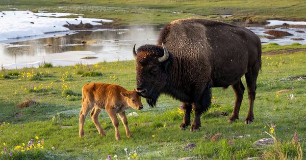
Grizzly bear. Interior Alaska’s grizzlies are smaller than coastal brown bears but no less impressive. They are regularly seen in the tundra corridor digging for arctic ground squirrels — an important pre-denning food source — and occasionally along river gravel bars feeding on early-season vegetation. June through early September offers the best sighting frequency.
Moose. The largest member of the deer family and a substantial presence in the river corridors. Cow-calf pairs are common in early summer. Bulls can be encountered anywhere along the road, most often in willow patches near water.
Caribou. The Denali Herd undertakes seasonal migrations across the park, and herds sometimes cross the road in groups ranging from a dozen animals to several hundred. Late August and September bring fall migration movement and good sighting odds.
Dall sheep. North America’s only wild white sheep inhabit the rocky ridges above treeline throughout the park. They are frequently visible from the road with binoculars — a white smear against gray rock at 1,500 feet that resolves into a group of ewes or a dominant ram once you have a scope on it. Binoculars are non-optional gear at Denali.
Gray wolf. Denali is one of the best places in North America to observe wolves in the wild, but they are seen far less reliably than the other four. Packs range across large territories. A wolf crossing the road — usually at a loping trot, unbothered by the bus — is the kind of sighting you describe for years afterward. It happens; count yourself fortunate if it does.
Photography at Denali in 2026
The road closure has materially affected landscape photography options at Denali. Wonder Lake’s reflection of the south face of the mountain — the iconic image that has appeared on park posters for generations — is currently inaccessible. The Reflection Pond near Wonder Lake, another prime mirror-image location, is also behind the closure. Eielson Visitor Center’s broad mountain view across open tundra is closed.
What remains for photographers:
Talkeetna flightseeing. The single best photographic access to Denali’s scale is a small-plane flight from Talkeetna, 100 miles south of the park entrance. Glacier-landing tours on the Kahiltna or Eldridge give direct views of the mountain’s upper faces that no road vantage can match. On a clear June morning the light on the upper glacier is extraordinary — worth building your itinerary around.
Entrance area and Savage River. Best accessible ground-level photography in the current road situation. September fall color — reds and golds from mid-August through mid-September — is excellent and fully accessible in this corridor.
Wildlife from the bus. A 400mm lens or 100-400mm equivalent is the right gear. Frequency of close encounters makes bus photography genuinely productive. Shoot from the window rest, not handheld.
Late-season tundra. Mid-August through mid-September brings fall color and peak bear activity before denning. Crowds thin. Bus service winds down by mid-September when the season closes.
Seasonality and When to Visit
The Denali Park Road typically opens for the season in late May, with bus service beginning around the same time. The entrance area and the first 15 miles open as soon as the road clears of snow, which varies year to year but usually happens by mid-May.
Peak season runs June through August. June offers the best odds of clear Denali views — the mountain is visible roughly one-third of summer days on average, and early morning is the most reliable window before convective clouds build over the peaks. July is the warmest and busiest month. August brings fewer crowds, excellent berry and wildflower conditions, and increasingly active wildlife behavior as bears begin preparing for hibernation.
Mid-August through mid-September is the fall color window and the most active wildlife period. Bear sightings increase as animals enter hyperphagia. The tundra transitions to amber, rust, and crimson. Bus service ends mid-September; the road closes late September. Winter access is extremely limited — no buses, minimal road maintenance, reduced facility hours.
Getting to Denali
From Anchorage: 240 miles north on the Parks Highway (Alaska Route 3), four to five hours. Most visitors fly into Anchorage and drive north — Denali is a natural centerpiece of any Alaska road trip.
From Fairbanks: 120 miles south on the Parks Highway, about two hours. A viable day-trip base, though most visitors prefer at least one or two nights near the park.
From Talkeetna: Roughly 100 miles south of the entrance, Talkeetna is the mountaineering gateway and the departure point for glacier flightseeing. If you plan a flightseeing trip, build a Talkeetna half-day into your itinerary.
Alaska Railroad: The railroad connects Anchorage and Fairbanks with a stop at the Denali entrance. The Alaska Range scenery along the route is spectacular — a genuine alternative to driving.
The nearest accommodations are in the Glitter Gulch / Healy corridor just north of the entrance, with hotels, lodges, and restaurants oriented toward park visitors.
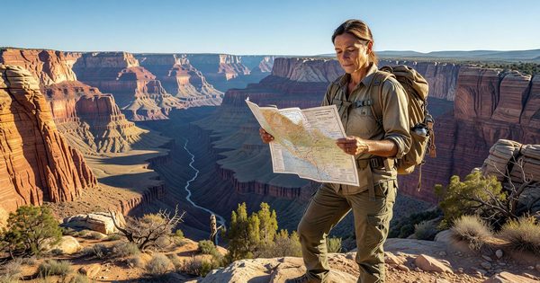
Backcountry Access and Permits
Denali permits open cross-country travel essentially anywhere in the park — there are no designated trail requirements outside the entrance corridor. You can walk off the bus at any point and navigate by topographic map across open tundra.
Backcountry camping is divided into numbered units with per-unit quotas. Permits are free but must be obtained in person at the Backcountry Information Center no earlier than one day before your trip. Popular units fill quickly on peak summer days. A bear canister is required for all overnight backcountry trips; rentals are available at the Backcountry Information Center.
Day hikes off the bus in the accessible Miles 15–43 corridor require no permit. Check in at the Backcountry Information Center for current wildlife activity and river water levels — crossings can be non-trivial in high water.
Accessibility
The Denali Visitor Center is fully accessible. Transit and tour buses are ADA-accommodated — indicate accessibility needs when booking. The Savage River Loop Trail is relatively flat and manageable for most mobility levels. Off-road tundra travel is uneven and difficult for those with limited mobility.
Frequently Asked Questions
Is the Denali Park Road fully open in 2026? No. The road is open to bus traffic only as far as Mile 43 (East Fork Bridge). The Pretty Rocks Landslide closure — ongoing since August 2021 — is expected through summer 2026. Eielson Visitor Center and Wonder Lake Campground are closed. Check nps.gov/dena before your visit.
Can I drive my own car on the park road? Private vehicles are permitted only on the first 15 miles, ending at Savage River. Beyond Mile 15, access requires a bus (transit or narrated tour). This rule has been in place since the 1970s and is unrelated to the landslide.
Who operates the Denali buses? The Doyon/Aramark Joint Venture holds the NPS concession. Reservations at reservedenali.com or Recreation.gov. Transit buses are seat-only; narrated tour buses include Driver Naturalists who stop for wildlife.
Can I see Wonder Lake in 2026? No. Wonder Lake at Mile 85 is behind the closure. The campground is closed. Flightseeing from Talkeetna is the best alternative for mountain photography.
When is the best time to see wildlife? Late May through mid-September. June and July are most reliable for bears. Late August and September bring pre-denning activity and fall tundra color.
How do I maximize my chances of seeing Denali’s summit? Plan two to three nights near the park. The mountain is fully visible roughly one-third of summer days; clearer in late May and early June. Early morning before 9 a.m. is the most reliable window before convective clouds build.
For current road conditions, bus reservations, and backcountry information: