There is a small metal sign bolted to the cliff face above Badwater Basin that reads “Sea Level” — and from the parking lot 282 feet below that sign, you have to crane your neck back to read it. That physical fact, the experience of standing well beneath the ocean’s surface while looking up at a sign marking where the water line would be, is the most efficient orientation to Death Valley I know. You are in a place of extremes. The lowest point in North America. The hottest recorded air temperature on Earth: 134°F at Furnace Creek on July 10, 1913. Annual rainfall averaging less than two inches. And an expanse of 3.4 million acres — making Death Valley the largest national park in the contiguous United States — covering a landscape that ranges from salt flats at -282 feet to Telescope Peak at 11,049 feet, with sand dunes, volcanic craters, slot canyons, and badland formations in between.
I’ve been coming to Death Valley since I bought my first serious camera, and the thing that most surprises first-time visitors isn’t the scale or the geology — it’s the light. The combination of clear desert air, low humidity, and surrounding mountain walls that catch the slanting sun produces a quality of light I’ve found almost nowhere else. In the cool months, that light is accessible. In summer, it will kill you.
The Seasonal Reality: Why November Through March Matters
Let me be direct about this, because the park’s name isn’t metaphorical. From May through September, Death Valley regularly records air temperatures between 110°F and 130°F. Ground surface temperatures on the valley floor can exceed 200°F during peak summer. The NPS reports heat-related deaths in the park almost every year — visitors who underestimated the conditions, ran out of water, or simply stepped out of their cars at the wrong time of day. The park service recommends avoiding strenuous outdoor activity entirely from May through September. I follow that recommendation without exception.
November through March is when Death Valley reveals itself as one of the most rewarding parks in the system. Daytime highs at valley elevations typically run from the mid-50s in December and January to the mid-70s by late February and March. The air is clear, the light is low-angle for most of the day, and the desert opens up. You can walk for hours on the salt flats, hike slot canyons, and stand on dune crests at sunset without worrying about surviving the experience. April is manageable in the mornings but warms quickly — I generally treat mid-April as the outer boundary of comfortable visiting. October is beautiful but warm enough to require caution. The sweet spot is mid-November through mid-March, and that’s the window I build my trips around.
One additional cool-season phenomenon worth monitoring: the superbloom. When winter rainfall — normally under two inches for the year — exceeds roughly six inches, dormant wildflower seeds across the valley floor germinate en masse. Desert gold (Geraea canescens), phacelia, desert five-spot, and dozens of other species cover entire sections of the valley in sheets of color from late February through mid-March. These events are rare and impossible to predict far in advance. The documented superbloom years — 2005, 2016, and 2024 — each followed unusually wet winter rainy seasons. The Death Valley wildflower forecast page at nps.gov publishes in-season updates as conditions develop. If you have flexibility and the forecast looks promising, it’s worth rearranging plans for.
Badwater Basin: Walking the Lowest Point
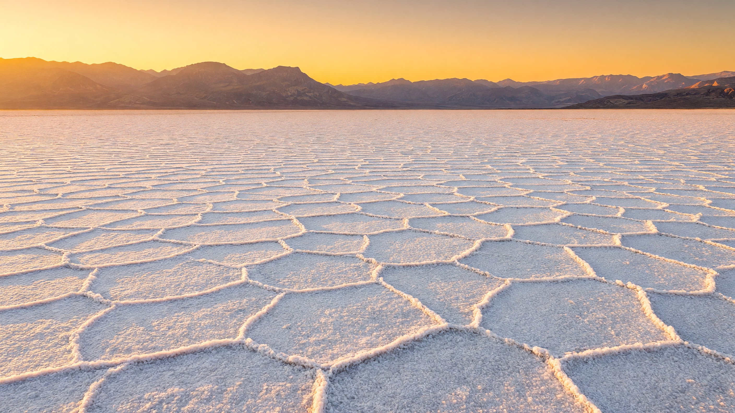
The 17-mile drive south from Furnace Creek on Badwater Road ends at the most remarkable flat surface I’ve ever stood on. A boardwalk extends out from the parking area onto the salt flat, and beyond the boardwalk the white expanse continues for miles — a vast sheet of sodium chloride crystals arranged into polygonal formations through repeated cycles of winter flooding and summer evaporation. In the right light (early morning, late afternoon), the salt surface catches the sun and glows. Under overcast skies it goes white and featureless. I’ve shot it in both conditions and the overcast version is underrated — the lack of hard shadows shows the polygon structure more clearly.
Walk out past the boardwalk end if the flat is dry. The crystals crunch underfoot and the scale becomes apparent: mountains on every side, no trees, no structures, the air completely still. Look back toward the road and find the Sea Level sign on the cliff wall. That’s the image I show people when I want to communicate where they are.
In winters following significant rainfall, shallow water pools on the basin floor and creates mirror reflections of the surrounding peaks and, on moonless nights, the Milky Way. The star reflection images from Badwater are some of the most technically demanding I’ve attempted — long exposure, cold temperatures, tripod in shallow water — but on good nights the results justify every minute of the setup.
Zabriskie Point: The Sunrise That Earns Its Reputation
Zabriskie Point has been photographed millions of times, and it still delivers. The eroded badland formations of ancient lake sediments — layered in tan, gold, and purple, carved into ridges and fins and hollows by water erosion — catch the first light of a clear morning in a way that makes every composition work regardless of where you point the camera. I set my alarm for well before dawn in December and January, drive up in the dark, and find a position on the viewpoint platform before the light arrives.
The formations are technically the remnants of ancient Lake Manly, which occupied the Death Valley basin during multiple ice-age pluvial periods when the climate was substantially wetter. The sediments were compressed, uplifted by tectonics, and then carved by episodic flooding into the landscape you see today. The U.S. Geological Survey’s Death Valley geology overview puts the basin’s formation in context — Death Valley sits in an actively extensional zone where the crust is being pulled apart, and the valley floor is still sinking at a measurable rate.
From Zabriskie, the Golden Canyon trail descends 1.5 miles to the canyon floor, then continues another 1.5 miles through the badland maze to the base of Red Cathedral — a towering red and ochre cliff face. The full Golden Canyon to Red Cathedral route is about 3 miles round trip, manageable for most visitors in cool weather. The canyon narrows are genuinely beautiful and feel like a different landscape from the open badlands above.
Artist’s Drive and Artist’s Palette
Nine miles south of Furnace Creek, Artist’s Drive is a one-way 9-mile scenic loop through eroded hills whose surfaces display an improbable range of colors: reds, pinks, purples, greens, and yellows from oxidized iron and other minerals in the volcanic deposits. The colors are most vivid at midday, which makes this one of the few spots in Death Valley where I actually prefer noon light to golden hour. The minerals that produce the greens (decomposed volcanic ash with chlorite) and pinks (manganese oxides) look washed out under low-angle side light but glow in overhead sun.
The road is one-way and requires no hiking — it’s entirely driveable in a standard passenger vehicle. Stop at the Artist’s Palette pullout about two-thirds through the loop for the densest concentration of color on the hillside. The surrounding landscape at this point looks like it was painted by someone who decided realism was less interesting than impact.
Dante’s View: The Full Valley Perspective
From the 5,475-foot overlook at Dante’s View on the eastern valley wall, you can see the full width of Death Valley simultaneously — Badwater Basin directly below, the salt flat stretching north, the Panamint Range rising to Telescope Peak (11,049 feet) on the far wall, and the Amargosa Range receding south. On clear winter mornings, the valley floor is sometimes in cloud shadow while Dante’s View stands in full sunlight, and the contrast between the dark valley and the bright peaks is extraordinary.
The drive to Dante’s View is paved and accessible by standard vehicle, though it gains significant elevation quickly. Allow an hour to walk the short trail above the parking area to the highest viewpoint and back. Blue hour here — the 20 minutes before sunrise and after sunset — is one of my favorite shooting windows in the entire park. The valley below holds onto darkness while the sky transitions through deep indigo to orange.
Mesquite Flat Sand Dunes: Sunset and Footprints
The Mesquite Flat Dunes near Stovepipe Wells are the most accessible and most photographed dunes in the park, reached by a short walk from the roadside parking area. The dunes reach about 100 feet at their highest crests, which is enough to create dramatic ridge lines and shadow gradients at low sun angles. I shoot them almost exclusively in the last 45 minutes before sunset, when the shadows on the windward faces go deep and the ridgelines catch orange light.
The key is arriving before other photographers disturb the sand on the main approach. The dunes nearest the parking area will have footprints from earlier in the day; walk further in — 15 to 20 minutes toward the higher crests — and you’ll find undisturbed surfaces with overnight wind ripple patterns still intact in winter. Coyote tracks are common in the morning. The walk to the highest crests and back takes about an hour at an unhurried pace.
Accessibility note: the parking area provides views of the lower dune field from ground level, and the flat sandy approach is walkable for visitors who cannot manage the full dune climb. The dunes are also one of the better locations in the park for visitors with mobility constraints — no paved surface, but the approach is flat and firm.
Ubehebe Crater: Volcanic Scale
In the park’s north end, away from the Furnace Creek corridor, Ubehebe Crater drops 600 feet from rim to floor — the result of a volcanic explosion that occurred roughly 2,100 years ago when rising magma contacted groundwater and triggered a phreatomagmatic eruption. The crater is a half-mile wide and the walls display alternating layers of volcanic ash and basalt that record multiple eruption phases. The rim trail circles the crater in about a mile; the descent to the floor is steep but doable in cool weather.
Nothing in the immediate vicinity prepares you for the scale of it. The drive through the north valley feels remote and flat, and then the crater simply appears — a massive hole in the earth edged in volcanic debris. Little Hebe Crater, a smaller and more colorful satellite crater, is visible from the west rim. The USGS Volcano Hazards Program maintains monitoring data on Ubehebe, which remains geologically active.
Key Hikes
Golden Canyon to Red Cathedral (3 miles round trip): The best short hike in the park for geological variety and photography. Starts at the Golden Canyon trailhead on Badwater Road, climbs through narrowing red-walled canyon into the badlands, and ends at the base of Red Cathedral’s towering cliff. Can be combined with a Zabriskie Point start or finish for a longer traverse.
Mosaic Canyon (2 miles round trip): A slot canyon near Stovepipe Wells with water-polished marble walls and breccia formations. The narrows in the lower section are the photographic target — the polished white and gray marble reflects light beautifully. The canyon opens into a broader dry wash above the narrows and continues to a viewpoint.
Telescope Peak (14 miles round trip, 3,000 feet elevation gain): The park’s highest summit at 11,049 feet, with views from the Sierra Nevada to the Spring Mountains of Nevada on clear days. Paradoxically, this is a spring through fall hike — the summit trail holds snow and ice from November through April, and the upper sections require crampons and ice axe in winter. If the summit is your goal, plan for May through October and carry adequate clothing for summit conditions that can be well below freezing even in July.
Furnace Creek: The Park Hub
Furnace Creek is where most visitors sleep, eat, refuel, and start their days. The NPS visitor center here has the best interpretive displays on Death Valley’s geology, ecology, and human history, and rangers at the information desk are reliably knowledgeable about current road and trail conditions. Check current conditions before heading to any remote areas — flash flood potential increases significantly after winter rain events, and several park roads become impassable without warning.
Lodging at Furnace Creek is operated by Xanterra Parks & Resorts, the park’s concessioner. The Inn at Death Valley is the historic upscale property — built in the 1920s, renovated multiple times, spring-fed pool, genuinely excellent restaurant — and books out months in advance for peak winter dates. The Ranch at Death Valley is the larger, more casual property adjacent to the visitor center, with motel-style rooms and a separate pool. Both are at Furnace Creek. Reservations are essential for any November through February travel; walking up without a reservation in December is not a realistic plan.
Furnace Creek Campground is the main developed campground, with RV hookup sites and tent sites. Stovepipe Wells Village, about 24 miles northwest, functions as a secondary hub with a small hotel, gas station, and campground — and is the better base for dune and Mosaic Canyon access.
Water, Fuel, and Practical Cautions
The NPS recommends one gallon of water per person per day as a minimum — and that’s for cool-season visiting. In practice I carry significantly more. Dehydration in dry desert air happens faster than people expect, and the park is large enough that vehicle breakdowns can leave you stranded in areas with no shade.
Gas stations are limited: Furnace Creek, Stovepipe Wells, and Panamint Springs are the only in-park options, and prices run 30 to 50 cents above outside rates. Fill up before entering if you’re coming from Beatty, Nevada (eastern access) or Lone Pine, California (western access via Highway 190). Cell service is essentially limited to the Furnace Creek area — download offline maps before entering. The park’s road system covers hundreds of miles, including significant unpaved sections requiring high-clearance or 4WD vehicles. Check road conditions at the visitor center.
Photography Notes
Zabriskie Point: Arrive 30 minutes before sunrise, position on the left side of the viewpoint platform for the best angle on the main badland formation. In winter, the sun rises to the southeast and lights the formation from the side rather than behind — this is the light that makes the published images.
Mesquite Flat Dunes: The last 30 to 45 minutes before sunset, walking north toward the higher crests. Wind ripple patterns are best preserved on north-facing dune faces. A polarizing filter reduces the sky’s brightness and helps the sand textures read clearly.
Dante’s View: Blue hour, positioned at the highest viewpoint above the parking area. A wide-angle lens handles the full valley width; a telephoto compresses the valley floor and Panamint Range into a single frame.
Badwater (star reflections): Requires a winter rain event to create pooled water on the salt flat, which happens only a few times most seasons. Check reports and arrive within 48 hours of a rain event — the water evaporates quickly. Cold temperatures, long exposures, and a very sturdy tripod.
Frequently Asked Questions
Is Death Valley really the hottest place on Earth? The 134°F air temperature recorded at Furnace Creek on July 10, 1913 remains the highest reliably recorded air temperature in world history, per NOAA’s National Centers for Environmental Information. Ground surface temperatures in Death Valley can exceed 200°F during summer — hot enough to cook an egg directly on the pavement.
What is the lowest point in North America? Badwater Basin in Death Valley, at 282 feet below sea level. The point is marked on Badwater Road approximately 17 miles south of Furnace Creek, and a boardwalk leads out onto the salt flat from the parking area.
What is the best month to visit Death Valley? December through February for the most comfortable temperatures and the clearest light. March adds the possibility of wildflowers in years with sufficient winter rain. November and early April are workable. May through September carries genuine heat-related danger and is best avoided for most visitors.
How big is Death Valley National Park? Death Valley covers approximately 3.4 million acres — making it the largest national park in the contiguous United States, roughly the size of Connecticut. The park extends across both California and a narrow sliver of Nevada.
What is a Death Valley superbloom? A superbloom occurs when an unusually wet winter triggers mass germination of dormant wildflower seeds across the valley floor. These events are rare — occurring perhaps three to four times per decade in significant form — and typically peak from late February through mid-March. The most recent major events were in 2005, 2016, and 2024.
Can I hike Telescope Peak in winter? No — or at least, not safely without mountaineering equipment. The upper Telescope Peak trail holds snow and ice from approximately November through April, and the summit requires crampons and ice axe in winter conditions. The paradox of Death Valley’s highest peak having a winter closure is real. Plan a May through October ascent instead.
Where should I stay in Death Valley? The Inn at Death Valley (historic, upscale, spring-fed pool) and The Ranch at Death Valley (larger, more casual) are both at Furnace Creek and operated by Xanterra Parks & Resorts. Both require advance reservations in winter. Stovepipe Wells Village is the secondary option. Multiple campgrounds exist throughout the park for those with tents or RVs.
Further reading: NPS Death Valley · National Parks Conservation Association · USGS Death Valley Geology · NOAA Climate Records