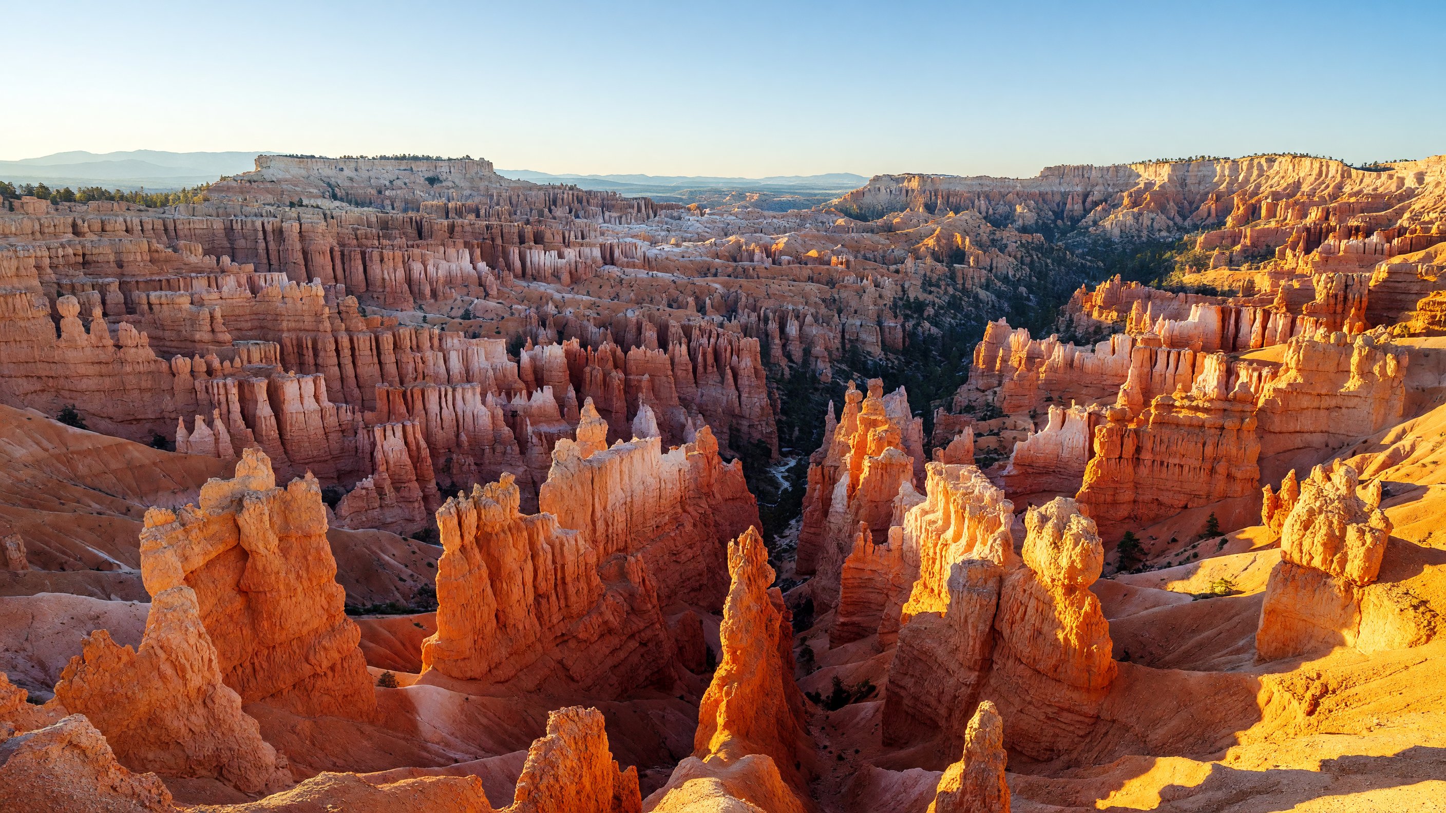
I have been to Bryce Canyon three times now — once in May with a full camera kit, once in late June during a thunderstorm that turned the amphitheater briefly violet, and once in January when half a foot of snow sat on top of the hoodoos and the whole place looked like a fever dream in white and orange. Each visit I think I’ve finally understood the scale of it. Each visit the rim view proves me wrong again. Bryce Canyon National Park covers 35,835 acres along the eastern edge of the Paunsaugunt Plateau in southern Utah, and it holds the highest concentration of hoodoos anywhere on Earth. What’s remarkable is not just that they exist here — it’s how many there are, and how insistently strange they remain no matter how long you stand there looking.
Why It Isn’t Actually a Canyon (And Why the Geology Is More Interesting Than the Name)
Here’s the thing most people don’t know before they arrive: Bryce Canyon is not a canyon. There is no river that carved it. The park is actually a series of natural amphitheaters — horseshoe-shaped bowls eroded into the eastern rim of the Paunsaugunt Plateau. The formations you’re looking at are the product of a different and more relentless force: frost-wedging.
Water seeps into cracks in the soft sedimentary rock — primarily limestone, mudstone, and siltstone deposited in ancient lakebeds and streams some 40 to 50 million years ago. When temperatures drop below freezing, that water expands as ice, prying the cracks wider. Temperatures melt the ice; water seeps deeper; the next freeze pries further. At Bryce Canyon’s elevations — ranging from around 6,620 feet at the park’s lowest point (Yellow Creek) to 9,115 feet at Rainbow Point — this freeze-thaw cycle happens on more than 200 nights per year. Over millions of iterations, the plateau edge fractures into the spires, walls, and columns we call hoodoos.
The hoodoos survive as long as they do because harder rock caps their tops, protecting the softer material beneath. When the cap erodes away, the column beneath weathers faster and eventually collapses. The landscape is not static. The hoodoo fields are still actively forming and still actively falling. What you’re photographing today looked different a decade ago, and will look different a decade from now.
The colors — ranging from ivory white through burnt orange to deep crimson — reflect different mineral compositions layered through the rock: iron oxides for the reds and oranges, manganese for the purples and lavenders that appear in the lower strata. The USGS geology resources contain detailed formation analysis of the Colorado Plateau sedimentary sequences if you want the full stratigraphic picture.
The 18-Mile Rim Road: Viewpoints Worth Stopping For
The park’s main road runs approximately 18 miles from the entrance to Rainbow Point at the southern end, climbing steadily as it goes. The conventional wisdom is to drive south first (to the highest point) and stop at viewpoints on the way back north — because you’re always descending toward the exit. I do it this way every time and it works.
Rainbow and Yovimpa Points are the southern terminus at 9,115 feet. On a clear day, the view east from Yovimpa extends 90-plus miles into the Four Corners region. These points are cooler than the amphitheater area and significantly less crowded.
Natural Bridge is the first major stop heading north from Rainbow Point. Despite the name, it’s technically a natural arch — formed by frost-wedging rather than stream erosion. Still striking, and easy to photograph from the roadside pullout.
Agua Canyon has two named formations visible from the overlook: The Hunter and the Rabbit. These are among the most distinctly shaped hoodoos in the park and reward a longer pause.
Ponderosa Canyon offers views down into a canyon floor dotted with large Ponderosa pines. The elevation drop from the rim to the treeline here gives a sense of the vertical scale.
Swamp Canyon marks the transition zone between the hoodoo-filled southern section and the Bryce Amphitheater. The vegetation changes noticeably here — the canyon holds more moisture.
Farview and Piracy Points are two adjacent overlooks where, on clear days, Navajo Mountain is visible about 90 miles to the southwest.
Bryce Point is what I’d call the default answer when someone asks where to go first. It sits at the southeastern end of the main amphitheater and looks directly across the Silent City — the densest concentration of hoodoos in the park. The panorama is wide and the formations are close enough to feel intimate. I’ve shot here at dawn and dusk and never gotten a bad frame.
Inspiration Point stands slightly higher than the other amphitheater overlooks and gives the most elevated perspective of the Silent City. Three separate viewing levels are accessible; the upper level offers the clearest sight lines across the full breadth of the formation field.
Sunset Point is the trailhead for the Navajo Loop and the Wall Street section. It’s named for its western exposure — the light here in late afternoon and early evening can be genuinely spectacular. Thor’s Hammer, the park’s most photographed hoodoo, is visible directly below from the rim.
Sunrise Point is exactly what it promises: the east-facing overlook that catches first light earlier than anywhere else in the amphitheater. I set an alarm every time and it is always worth it. The hoodoos go from dark silhouettes to glowing orange over about fifteen minutes at sunrise, and the color temperature shift is extraordinary if you’re shooting RAW. Bring a tripod. You want sharp frames at f/8 in low light, not a high-ISO compromise.
Trails: From the Rim to the Floor
The single best decision you can make at Bryce Canyon is to go down. The rim views are remarkable. The trail views, once you’re inside the amphitheater with hoodoos rising 60 feet above you on both sides, are in a different category entirely.
Navajo Loop Trail (1.3 miles, ~550 feet elevation change): The quickest descent into the amphitheater. The Navajo Loop drops from Sunset Point through two sections: the Standard route and Wall Street, a narrow canyon slot barely wide enough for two people to pass. Wall Street is the one you want — the walls of the slot rise more than 100 feet and two Douglas firs grow improbably from the canyon floor in the middle of it. The entire loop takes 60 to 90 minutes. It is steep going down and steep coming back up, but the total distance is short enough that most reasonably fit visitors can manage it.
Queen’s Garden Trail (1.8 miles, ~320 feet elevation change): The gentler alternative — the longest trail that descends from the rim with the least sustained grade. It drops from Sunrise Point through formations to a garden area below the Queen Victoria formation, a large hoodoo that resembles a figure in a crown. The Queen’s Garden route is a good choice if the Navajo Loop’s steeper sections are a concern, or if you prefer a quieter approach to the amphitheater floor.
Navajo/Queen’s Garden Combined Loop (2.9 miles): The trail I recommend to nearly everyone visiting for a half day. Descend via Navajo Loop from Sunset Point (through Wall Street), traverse the amphitheater floor, and return to the rim via Queen’s Garden to Sunrise Point. The connecting trail on the amphitheater floor is relatively flat, and the variation between the two trails means you see more of the formation field. Shuttle between Sunrise and Sunset Points (or walk the short paved rim section) to close the loop. Plan two to three hours and a full water bottle per person.
Peekaboo Loop (5.5 miles, ~1,600 feet elevation change): The intermediate backcountry option — a longer, more isolated loop on the amphitheater floor that sees significantly less foot traffic than the Navajo/Queen’s routes. Access via Bryce Point or from the Navajo Loop junction. The trail passes through the densest hoodoo terrain in the park and has earned a reputation as the best single hike in Bryce Canyon among people who’ve done all of them. Horses share this trail; yield by stepping off the downhill side and speaking calmly.
Fairyland Loop (8 miles, ~2,309 feet elevation change): For hikers who want the amphitheater mostly to themselves. The Fairyland Loop begins away from the main visitor area at Fairyland Point — north of the visitor center — and sees a fraction of the traffic on the Navajo/Queen’s routes. The formations in the Fairyland basin are distinctive and the canyon floor is quieter. Full day required; start early.
Under-the-Rim Trail (23 miles, backcountry): The park’s long-distance wilderness route, running below the rim from Bryce Point south to Rainbow Point. Backpacking permits required (available at the visitor center). Water sources are limited and must be treated; the route is for experienced backcountry travelers comfortable with desert water management and navigation. The trail passes through terrain and viewpoints accessible no other way.
Rim Trail (11 miles, minimal elevation change): The paved section between Sunrise and Sunset Points is wheelchair accessible and takes about 30 minutes at a moderate walk. The full rim trail continues in both directions on unpaved surface to Bryce Point (south) and Fairyland Point (north). This is the right choice for visitors who need to stay flat, for families with young children, or for anyone who wants to connect multiple viewpoints without a car.
Bryce Canyon as a Dark Sky Destination
Bryce Canyon National Park holds International Dark Sky Park designation from DarkSky International (formerly the International Dark-Sky Association), recognizing it as one of the darkest large-scale night environments in the lower 48 states. At 8,000-plus feet with minimal nearby development and clean high-elevation air, the park delivers Milky Way visibility that requires serious travel to find anywhere else in the contiguous United States.
The park’s annual Astronomy Festival, typically held in late June, draws amateur astronomers, astrophotographers, and ranger-led stargazing programs to the rim. Events include telescope viewing sessions at designated observation areas, constellation talks, and guided dark-sky walks. For exact dates in your planning year, check the official Bryce Canyon NPS website — the festival date shifts slightly year to year. The park also runs ranger-led stargazing programs throughout the season, generally scheduled around new moon periods for maximum sky darkness.
For photography, the Bryce Amphitheater viewpoints — particularly Sunrise and Bryce Points — double as Milky Way platforms from April through October. The hoodoos in the foreground against a star-filled sky is one of the more technically demanding but rewarding composition challenges in landscape photography. A wide-angle lens (16-24mm full frame equivalent), an f/2.8 or faster aperture, and a foreground illumination strategy (a low-power headlamp to paint the hoodoos during a long exposure) are the core kit. For a full comparison of the best dark sky parks in the region — including Bortle class ratings, moon-phase planning, and meteor shower timing — see the stargazing guide for Western national parks.
Photography: Timing, Locations, and What to Actually Shoot
Sunrise Point lives up to its name for photographers, but the specific value is the east-facing exposure catching low-angle morning light that warms the entire amphitheater simultaneously. The color progression from blue-hour silhouettes to gold-lit spires happens quickly — 20 to 30 minutes from first usable light to full sun washing out the shadows. Be set up 45 minutes before civil sunrise. For a broader look at how Sunrise Point compares to other Western park dawn locations — including Mesa Arch, Schwabacher Landing, and Tipsoo Lake — see the Best Sunrise Photography Spots in Western US National Parks.
Sunset Point’s western exposure gives the inverse: the richest light arrives in the 30 minutes before sunset, when the low sun side-lights the hoodoos and the shadows between formations go deep blue-purple. Thor’s Hammer — the standalone capped hoodoo visible directly below the overlook — is the classic compositional anchor.
Bryce Point is the location I return to most. The wide panoramic perspective of the Silent City makes compositional cropping flexible, and the formations visible from the rim here are close enough to fill a 70-200mm frame without losing the sense of scale. Early morning and late afternoon both work; midday does not.
Gear notes: A polarizing filter is useful here in a way it often isn’t in canyon country — the high elevation and clear skies mean midday glare can blow out highlights on the white limestone caps of hoodoos. A polarizer recovers two to three stops of dynamic range on those highlights. For tripod shooting on the paved rim sections, any standard travel tripod works; for the backcountry trails, keep it lightweight.
The Lodge at Bryce Canyon
The Lodge at Bryce Canyon is the only lodging option inside the park, operated by Aramark under a National Park Service concession agreement. The property sits a short walk from the Bryce Amphitheater rim and includes the main lodge building with suites, two motel-style wings (Sunrise and Sunset), and historic Western Cabins — smaller freestanding cabins with a period character that makes them the most sought-after accommodation in the park. The cabin interiors are simple but the porch-sitting at dusk, with no light pollution and no road noise, is the real draw.
Operating season runs from early spring through late fall — the main lodge from March through November, with cabins available roughly April through mid-October. Reservations open far in advance and peak dates book out quickly; plan six months ahead or more for summer weekends. For current availability and reservations, the park directs visitors to visitbrycecanyon.com.
Outside the park, the towns of Tropic (12 miles east) and Panguitch (25 miles north) have motel options and are common bases for budget-conscious visitors.
Seasonal Planning
Spring (April–May): Excellent photography season — dramatic cloud formations, wildflowers in the meadows above the rim, and temperatures ranging from the 40s°F at night to 60s°F during the day. Trails can be icy in early April; microspikes are worth carrying for the steep descents. The shuttle runs from early April.
Summer (June–August): Peak season. Daytime temperatures on the rim run 70-80°F — manageable for hiking, but afternoon thunderstorms arrive with regularity from mid-July through August. The lightning exposure on the open rim and in the amphitheater is real; the rule is to be off exposed terrain by early afternoon on stormy days. Check morning forecasts before committing to a long trail. Nights remain cool (40s-50s°F) — a jacket is not optional even in August.
Fall (September–October): My preference for this park. Aspens and Ponderosa pines on the plateau turn yellow and orange in late September and early October, adding color context to the red rock that the other seasons lack. Temperatures are ideal for hiking. Crowds thin after Labor Day. The angle of autumn light is lower and warmer than summer’s harsh midday sun.
Winter (November–March): Snow on hoodoos is genuinely spectacular — the orange and white contrast is one of the more unusual color combinations in American landscape photography. The park is open year-round, but some roads close temporarily after heavy snowfall and many services operate on limited schedules. Snowshoe rentals are available at the visitor center. Nights are severe — well below freezing — and hikers need full winter gear for any trail descent.
The elevation matters throughout all seasons. Bryce Canyon’s rim sits between 8,000 and 9,100 feet. Visitors arriving from sea level may notice altitude effects — headache, mild breathlessness, fatigue — especially on the first day. Drink more water than you think you need and ascend slowly back up from the amphitheater trails.
Getting There and Getting Around
From Salt Lake City, the drive is approximately 4 to 4.5 hours south via I-15, then US-89, then UT-12, then UT-63. From Las Vegas, it’s about 4 hours northeast. The nearest commercial airport is St. George Regional Airport, roughly 90 miles southwest. Bryce Canyon pairs naturally with Zion National Park (about 80 miles southwest on UT-12 and US-89) and Arches National Park (roughly 250 miles northeast) for a multi-park Utah road trip.
The free park shuttle runs approximately April through mid-October (2026 season: April 3 – October 18), operating 8 a.m. to 8 p.m. in peak summer and reduced hours in shoulder season. The shuttle serves 15 stops including the visitor center, all major amphitheater viewpoints, Bryce Canyon Lodge, and the campgrounds. During peak season, using the shuttle is strongly recommended — the Sunrise and Sunset Point parking lots fill by 8 a.m. on summer weekends. All shuttles are wheelchair accessible.
Private vehicles can drive the full 18-mile rim road year-round during road-open conditions; the southern drive beyond the shuttle zone is always open to personal vehicles.
Entrance fee: $35 per vehicle (7-day pass). The America the Beautiful annual pass is accepted.
Accessible Visits
The paved section of the Rim Trail between Sunrise and Sunset Points is fully accessible and delivers the core amphitheater experience without trail descent. Bryce, Inspiration, Sunrise, and Sunset Points all have accessible parking and overlook areas. The shuttle is wheelchair accessible with ramps at all stops.
The trails into the amphitheater involve steep grades, loose rock, and uneven surfaces that are not generally accessible by wheelchair. The rim viewpoints are the recommended experience for visitors who cannot manage the trail descents.
Frequently Asked Questions
How difficult is hiking down into Bryce Canyon’s amphitheater? The descent trails — Navajo Loop and Queen’s Garden — involve 300 to 550 feet of elevation change on steep, well-maintained switchbacks. The descent itself is manageable for most adults; the return climb is harder than it looks, especially at elevation. Trekking poles reduce knee strain significantly on the descent. Allow more time than you expect for the climb back out.
Is Bryce Canyon actually a canyon? No. It’s a series of natural amphitheaters carved into the edge of the Paunsaugunt Plateau by frost-wedging — not a canyon cut by a river. The distinction matters geologically because the formation mechanism (freeze-thaw erosion rather than water erosion) is what produces the hoodoo shapes specific to this location.
When is the best time to photograph Bryce Canyon? Sunrise Point at sunrise and Sunset Point in the 30 minutes before sunset are the two peak windows. Bryce Point is versatile across the day. For Milky Way photography, any clear, moonless night from April through October; new moon periods are optimal.
What is Bryce Canyon’s IDA Dark Sky designation? Bryce Canyon is an International Dark Sky Park, designated by DarkSky International for its exceptional nighttime darkness and its commitment to protecting night sky conditions for visitors and wildlife. The park hosts ranger-led astronomy programs throughout the season and an annual Astronomy Festival in late June.
Do I need a permit for any trails at Bryce Canyon? Most day hikes — including Navajo Loop, Queen’s Garden, Peekaboo Loop, and Fairyland Loop — require only standard park admission with no separate trail permit. Overnight backcountry travel on the Under-the-Rim Trail and Riggs Spring Loop requires a backcountry permit available at the visitor center.
Is the shuttle mandatory? No, but it’s strongly recommended during peak season (late spring through summer). The viewpoint parking lots fill early on busy days, and the shuttle eliminates the parking problem entirely. It’s free with park admission.
What gear do I need for the amphitheater trails? Sturdy hiking shoes with ankle support (the switchbacks have loose gravel), at least 1.5 liters of water per person, sun protection (the amphitheater walls do not shade the trails until mid-morning), and trekking poles if you have them. For winter visits, microspikes for the descent trails.
For current trail conditions, shuttle schedules, and permit information, see the official Bryce Canyon National Park page at nps.gov. For conservation advocacy and park funding news, the National Parks Conservation Association covers Bryce Canyon and the broader national park system. Geological formation data for the Colorado Plateau region is documented through the USGS Geologic Investigations series. Dark sky designation information is maintained by DarkSky International.