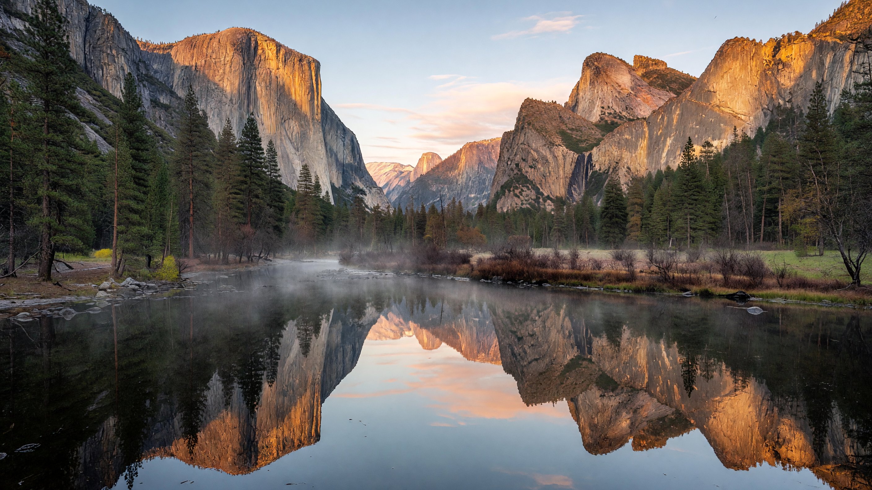
I drove into Yosemite Valley for the first time in late March, arriving well before the gate opened, and I still remember the physical shock of rounding a bend and seeing El Capitan appear through the windshield. No photograph prepares you for the scale. The wall rises 3,000 feet from the Valley floor — nearly twice the height of the Empire State Building — and it just keeps going. Half Dome, visible from Sentinel Bridge as a near-perfect reflection in the Merced River at dawn, looks sculpted rather than eroded. At roughly 759,000 acres across the central Sierra Nevada, Yosemite is one of the most visited parks in the national system, and the logistics of getting there — especially for a spring or summer trip — require real advance planning in 2025.
The 2025 Reservation System: What Has Changed
Yosemite’s vehicle reservation requirements have been in flux since 2020, when the park first implemented timed entry as a COVID-era crowd management tool. The system was modified, suspended, and reinstated across several seasons as the park experimented with what actually works at the Valley floor. For the 2025 spring and summer season, the National Park Service reinstated a modified peak-hour day-use reservation for vehicles entering Yosemite Valley.
Under the 2025 system, day-use vehicles entering the Valley during peak hours — generally between 6:00 a.m. and 4:00 p.m. from late April through early October — require advance reservations booked through Recreation.gov. Reservations open in advance at 8:00 a.m. Pacific time and fill quickly, particularly for weekends and holiday periods between May and September. The specific release window and exact operational dates for 2025 are published on the NPS Yosemite reservations page; check there before booking, as conditions and dates are subject to annual adjustment.
Vehicles arriving outside the reservation window — before 6:00 a.m. or after 4:00 p.m. — do not require a day-use reservation. This makes early morning arrival a genuinely strategic move: you’ll beat the reservation window, the parking competition, and secure the best light for photography at Tunnel View or Sentinel Bridge. Guests staying overnight at park campgrounds or lodges are not subject to the day-use reservation requirement for the duration of their stay; your lodging confirmation covers your vehicle entry. YARTS bus service from gateway communities (Merced, Mariposa, Mammoth Lakes via Tioga) also bypasses the reservation requirement entirely and runs on a reliable summer schedule.
The NPS has been clear that the reservation system is an ongoing experiment in balancing access with resource protection. Check the official park website and sign up for park alerts at Recreation.gov well before your trip — reservation windows and hour requirements can shift between when this article was written and when you’re planning.
Four Regions, One Park: Getting Your Bearings
Most visitors think of Yosemite as the Valley. That’s understandable — but it’s about 7 of the park’s 759,000 acres. Understanding the four major regions helps you plan a trip that actually uses the park’s full range.
Yosemite Valley is where most first-timers spend all of their time: the 7-mile-long, half-mile-wide valley floor flanked by El Capitan, Half Dome, Bridalveil Fall, and Yosemite Falls. The Valley has the primary visitor services (Yosemite Village, Yosemite Valley Lodge, the Ahwahnee Hotel, the main visitor center), the shuttle bus network, and the iconic viewpoints. It rewards slow exploration — the Valley Loop Trail, either on foot or by bike, connects the major features.
Wawona and the Mariposa Grove of Giant Sequoias occupy the southern end of the park along Highway 41. Wawona is a historic community with the Wawona Hotel (now managed by Aramark under the Delaware North concession contract) and the Pioneer Yosemite History Center. The Mariposa Grove — Yosemite’s largest sequoia grove — underwent a major restoration project completed in 2018 that removed parking, restored meadow hydrology, and improved trail systems. The grove is now accessed by shuttle from the Mariposa Grove Welcome Plaza. The Grizzly Giant, estimated at over 1,800 years old, is the standout specimen; the California Tunnel Tree (you can walk through it) brings in the photographers.
Glacier Point and the South Rim provide the elevated perspectives that put the Valley’s geology into context. Glacier Point at 7,214 feet offers a direct sightline down to Half Dome and across to the High Sierra — it’s the vantage point most people recognize from the classic aerial-ish photographs. The Glacier Point Road is typically open from late May through early November, depending on snow. In winter, the road is closed to vehicles but open to cross-country skiers. Badger Pass Ski Area, on the Glacier Point Road, is the only downhill ski area in the park and a useful reference point for winter visitors.
Tuolumne Meadows and the Tioga Pass Corridor define the high country along Tioga Road (Highway 120 East). At 8,600 feet, Tuolumne Meadows is the largest subalpine meadow in the Sierra Nevada — a genuinely different world from the Valley, with granite domes, glacial tarns, and a summer population of marmots that seems to have no fear of humans. Tioga Road is typically closed from mid-October through late May, depending on snowpack; Caltrans maintains the road opening status at dot.ca.gov and it’s worth checking before any spring attempt to cross.
Valley Logistics: Shuttle, Parking, and Getting Around
The Valley’s free shuttle system is the single most useful tool for stress-free navigation. Running year-round between the Valley Visitor Center and major trailheads and services, the shuttle eliminates the parking scramble that defines a summer morning near Sentinel Bridge or Yosemite Village. The eastern Valley loop (Route 1, the main visitor shuttle) runs every 10-20 minutes; the El Capitan Shuttle operates seasonally on the western end.
Parking in the Valley is genuinely limited. If you’re arriving with a day-use reservation, budget time for the shuttle to take you from wherever you find parking to your actual destination. The main day-use parking areas — Yosemite Village, Curry Village, and along the Valley floor — fill before 10:00 a.m. on any summer weekend. Arriving before 7:00 a.m. gives you a realistic chance of parking close to your first stop. Cell coverage is intermittent; download the NPS Yosemite app with offline maps before you leave the gateway town.
The Valley is also excellent by bike. Rentals are available at Yosemite Valley Lodge and Curry Village in summer. The mostly flat, paved multi-use paths connect the major features without the road traffic, and cycling allows a pace between driving and walking that suits the Valley particularly well.
Photography: Where to Go and When
Yosemite is one of the most photographed landscapes in the world, which means the iconic shots are genuinely crowded — but also that the light windows are well-documented.
Tunnel View at the east end of the Wawona Tunnel is the Valley’s signature composition: El Capitan on the left, Bridalveil Fall on the right, Half Dome centered in the distance, and the Valley floor receding between them. The view is spectacular at any time of day but genuinely extraordinary at golden hour — particularly at sunset in fall when low-angle light catches the granite walls and the Valley fills with haze from the afternoon. Arrive 30–45 minutes before sunset to claim a position; the pullout fills fast. A tripod and a wide-angle lens between 16mm and 35mm (full-frame equivalent) suit the composition.
Sentinel Bridge at dawn gives you the Half Dome reflection shot when the Merced River is calm and the Valley is still in shadow. Arrive before first light and wait — the reflection comes in that window between astronomical twilight and sunrise when the sky has color but the granite hasn’t yet blown out. A polarizing filter helps in late spring when the river runs high.
Glacier Point shoots best toward late afternoon and early evening, when the shadow line crawls up the north face of Half Dome and the High Sierra begins to glow. At night, Glacier Point is one of the best accessible dark-sky viewing spots in the park — drive up after dinner and wait for the Milky Way to clear the eastern horizon from roughly May through September.
Cathedral Lakes in Tuolumne Meadows offers reflection shots that never get as much attention as the Valley viewpoints despite being among the most compositionally rich in the park. Lower Cathedral Lake — 3.6 miles from the trailhead on Tioga Road — sits below the serrated granite spires of Cathedral Peak and reflects them perfectly in calm morning conditions. Late July is peak wildflower timing in Tuolumne, when the meadow margins run with lupine and shooting stars and the light at 8,600 feet has a clarity that lower elevations don’t match.
Bridalveil Fall is best visited in mid-morning when the sun backlights the spray. The fall flows year-round (unlike Yosemite Falls, which dries up by late summer) and in March and April runs wide and powerful. The paved accessible path brings you to the base in about 10 minutes from the parking area.
Major Hikes: From Valley Floor to High Country
Mist Trail to Vernal and Nevada Falls is the Valley’s most rewarding short hike and one of the best waterfall trails in the Sierra. The route leaves from Happy Isles trailhead and climbs 5.4 miles round trip (to the top of Nevada Fall and back via the John Muir Trail, looping through Clark Point) with about 1,900 feet of elevation gain. The Mist Trail section alongside Vernal Fall is exactly what the name implies — in peak spring flow (May), the spray soaks hikers completely and a poncho is not optional. The granite staircase alongside the fall is beautiful and brutally slippery when wet; traction matters. Nevada Fall, at 594 feet, is the showpiece at the top.
Yosemite Falls Trail climbs 7.2 miles round trip with 2,700 feet of gain to the top of Upper Yosemite Fall, the tallest waterfall in North America at 1,430 feet (the combined system is 2,425 feet). The lower fall is accessible via a 1-mile paved loop from Yosemite Village with minimal elevation gain — that’s the accessible option. The full trail to the upper fall is strenuous and fully exposed; start early, bring more water than you think you need, and time it for April through June when flow is at maximum.
Half Dome via the Mist Trail is a 14- to 16-mile round trip with approximately 4,800 feet of elevation gain, and it requires both a permit and a very early start. The cable section on the final approach — 400 vertical feet on 45-degree granite with steel cables and wooden rungs — is the technical crux. The cables are typically up from the Friday before Memorial Day through the day after the second Monday in October (Columbus Day weekend), though installation dates shift with conditions. The permit lottery through Recreation.gov opens in early March for the preseason draw and then daily for 2-day-advance slots; competition is intense and applying for multiple dates significantly improves odds. Start no later than 6:00 a.m. — longer in high season.
Cathedral Lakes (8 miles round trip, 1,000 feet gain) starts from Tioga Road near Tuolumne Meadows and reaches two pristine alpine lakes below Cathedral Peak. This is the Tuolumne showpiece for photographers and anyone wanting genuine Sierra backcountry experience on a day hike. Accessible only when Tioga Road is open — typically late May through mid-October.
Mariposa Grove: Giant Sequoias After the Restoration
The 2018 restoration of the Mariposa Grove was a significant undertaking: the NPS removed a large surface parking lot, redirected vehicle access, restored historic meadow hydrology, rebuilt trail drainage, and reopened the grove to foot and shuttle traffic after a nearly two-year closure. The result is a grove that feels less like a tourist attraction and more like what it is — a 250-acre forest of living things some of which have been growing for longer than the Roman Empire has been gone.
The Mariposa Grove Road is closed to private vehicles; access is via free shuttle from the Mariposa Grove Welcome Plaza at the south entrance. The 2-mile round trip to the Grizzly Giant and California Tunnel Tree covers the main features. The longer Outer Loop Trail extends to the upper grove where the Wawona Tunnel Tree (fallen in 1969) and Mariposa Grove Cabin add historical context. Snowshoe tours operate in winter when the grove is quiet and the sequoias are snow-draped. For the largest giant sequoias in the world by volume — including the General Sherman Tree — Sequoia National Park lies roughly 75 miles to the south and is a natural companion stop on any Sierra Nevada itinerary.
Waterfalls: Peak Timing
May is waterfall month in Yosemite. The combination of snowmelt from the high country and spring rainstorms produces the highest flow for Yosemite Falls, Nevada Fall, Vernal Fall, Bridalveil Fall, and the dozens of smaller ribbon falls that cascade from the Valley rim. By late June, high-elevation snowmelt begins to slow. By August, Yosemite Falls often stops running entirely and Nevada Fall drops to a fraction of its peak volume. Bridalveil Fall, fed in part by springs and seeps, runs year-round at varying intensity.
For real-time waterfall conditions, the NPS Yosemite current conditions page publishes weekly updates during the spring season. USGS stream gauge data for the Merced River at Happy Isles provides a reliable proxy for Valley waterfall intensity — find it through the USGS Water Resources portal.
Accessibility in the Valley
The Valley floor has a meaningful number of accessible experiences. The Yosemite Valley shuttle is accessible with ramp access. The Lower Yosemite Falls paved trail (approximately 1 mile, gentle grade) reaches a viewpoint of the lower fall. The Cook’s Meadow Loop and Valley View are both paved and accessible. Sentinel Beach picnic area is accessible and one of the better spots to spend a mid-day break near the Merced River. The Valley Visitor Center is fully accessible.
The Mariposa Grove’s main lower trails post-restoration are surfaced and accessible to most mobility levels, though the upper grove involves significant grade changes. Tioga Road itself, when open, gives vehicle access to Tuolumne Meadows with accessible facilities at the Tuolumne Meadows Visitor Center and Lodge.
The Ahwahnee and Valley Lodging
The Ahwahnee Hotel, the park’s flagship property, was built in 1927 and is managed by Aramark (the current park concessioner). Its stone-and-timber Great Lounge, leaded glass windows, and hand-carved details are genuinely worth seeing whether or not you’re staying. The Ahwahnee Dining Room is the Valley’s most formal dining option; reservations are required for dinner. Aramark also manages Yosemite Valley Lodge, Curry Village (Half Dome Village), and Housekeeping Camp for a range of price points and accommodation styles.
All park lodging is booked through the Aramark concessioner portal and sells out months in advance for peak season dates. Campground reservations through Recreation.gov follow the same pattern: high-demand dates for Valley campgrounds like Upper Pines, Lower Pines, and North Pines open 5 months in advance and are gone within minutes.
Frequently Asked Questions
Do I need a reservation to enter Yosemite Valley in 2025? Yes, for the 2025 spring and summer peak season, day-use vehicles entering Yosemite Valley during peak hours (approximately 6:00 a.m. to 4:00 p.m.) require advance reservations through Recreation.gov. Vehicles arriving outside those hours, visitors arriving by YARTS bus, and guests staying overnight at park facilities do not need a separate day-use reservation. Check the official NPS reservations page for exact 2025 dates and any updates to the system.
When is Yosemite’s waterfall season at its peak? May is peak waterfall month. Snowmelt from the Sierra Nevada feeds Yosemite Falls, Nevada Fall, Vernal Fall, and Bridalveil Fall simultaneously at their highest volume. Yosemite Falls typically peaks in late April through May and can slow to a trickle or stop by late August. Bridalveil Fall flows year-round.
How do I get a Half Dome permit? Half Dome day-hike permits are allocated through a preseason lottery (applications open in early March, results in mid-March) and a daily 2-day-advance lottery — both run through Recreation.gov. Permits are required only when the cables are up (late May through mid-October). Apply for multiple dates in the preseason draw to improve your odds. Backpackers with wilderness permits may access Half Dome without a separate day-use permit.
When does Tioga Road open and close? Tioga Road (Highway 120 East) typically opens in late May or early June, depending on winter snowpack, and closes in mid to late October with the first major storms. The exact dates vary significantly by year — check Caltrans road conditions at roads.dot.ca.gov for current status before planning a Tuolumne Meadows visit.
Is the Mariposa Grove of Giant Sequoias accessible without a car? Yes. The Mariposa Grove Road is closed to private vehicles. Access is via free shuttle from the Mariposa Grove Welcome Plaza near the south entrance on Highway 41. The welcome plaza has a small parking area; during peak season, it fills early. The main lower grove trails are accessible on foot.
What is the best time of year to visit Yosemite for photography? Late April through May for waterfalls at peak flow; July for Tuolumne Meadows wildflowers; October for fall light on Valley walls and smaller crowds. March and April offer Bridalveil Fall at full force and occasional Valley floor snow. Winter (December–February) brings the fewest crowds and the most dramatic snow-on-granite conditions.
Is a park pass required in addition to a day-use reservation? Yes. The vehicle entry fee ($35 as of 2025) or a valid America the Beautiful interagency pass is required separately from the day-use reservation. Hold both when approaching the entrance station.
Official park information: NPS Yosemite · Recreation.gov Half Dome permits · National Parks Conservation Association · Caltrans Highway 120 / Tioga Pass conditions · USGS Merced River stream gauge