The first time I stood at the base of the General Sherman Tree, I did what everyone does: I looked up, craned my neck back as far as it would go, and still couldn’t take in the whole thing at once. That trunk — 36.5 feet wide at the base, nearly twice the width of my living room is long — disappears into a canopy so high that the lowest branches (themselves 130 feet up and larger than most trees you’ve ever seen) are just a suggestion in the light. At roughly 52,508 cubic feet of volume and an age estimated between 2,300 and 2,700 years, the General Sherman Tree is the largest living thing on Earth by volume. Not the tallest, not the oldest, not the widest — just the largest, in the most comprehensive sense. Sequoia National Park was built around it and the grove it anchors, and the Giant Forest grove contains more of the world’s largest giant sequoias than anywhere else on the planet.
What I didn’t understand before my first visit was the scale of what surrounds that single tree. The park protects approximately 404,000 acres of Sierra Nevada terrain spanning foothill chaparral to alpine peaks. It is administered jointly with adjacent Kings Canyon National Park to the north, and the combined area — roughly 865,000 acres — is one of the largest protected wilderness blocks in the lower 48. Your entry fee covers both parks, and the Generals Highway connects them in a single continuous drive.
Giant Forest: The Core of the Park
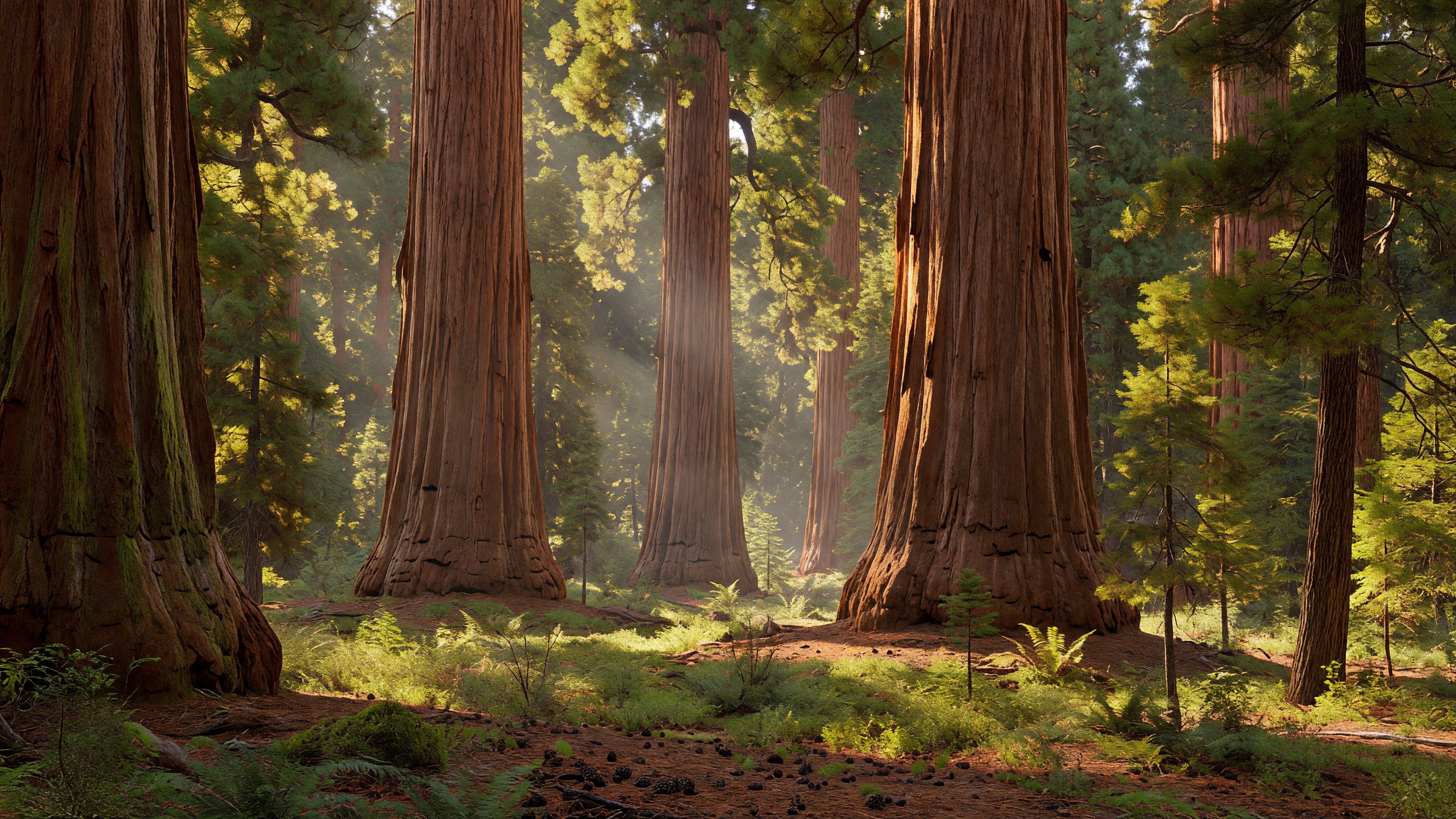
Giant Forest is the destination that most visitors come for, and it earns the attention. The grove here — centered on the General Sherman Tree, the Congress Trail, and the meadow complex that John Muir called the “gem of the Sierras” — holds more of the world’s 30 largest trees by volume than any other location. The density is astonishing. You walk away from the Sherman Tree thinking you’ve seen the standout, and ten minutes later you’re standing next to something equally enormous and just as old.
General Sherman Tree sits at the upper end of the Giant Forest grove accessible from two trailheads. The main lot fills fast in summer — the free park shuttle, which runs from the Wuksachi area and Lodgepole Campground to the Sherman trailhead, Moro Rock, and Crescent Meadow, is the practical solution. The accessible parking area on Wolverton Road offers a paved, downhill half-mile path to the tree; the return is uphill but short and entirely doable. If you park at the main General Sherman lot, it’s a flatter approach on the other side. Either way, go early — before 9:00 a.m. if you can — and the tree will be yours.
Congress Trail, the two-mile paved loop from the General Sherman Tree through the heart of the grove, is the essential Sequoia hike. The trail threads through clusters of named giants — the President, the Chief Sequoyah, the House Group — and the experience of walking among trees this large for this long recalibrates something in your sense of scale that a single viewpoint doesn’t. The light through the grove in mid-morning, when sun angles through the canopy at 45 degrees and the red bark catches it, is genuinely extraordinary for photography. I shoot it with a wide-angle lens as close to the base as I can get — you need the distortion to convey the height — and I’ve never left a roll unhappy.
Crescent Meadow at the end of the Crescent Meadow Road (accessible by shuttle in summer, vehicle-restricted in peak season) is where Muir’s description comes from. The meadow is ringed by sequoias, and the combination of open grassland, bog wildflowers in spring, and ancient trees at the margins makes it the most photographically varied spot in the park. Tharps Log, at the meadow’s edge, is a hollowed-out fallen sequoia that settler Hale Tharp actually used as a summer shelter in the 1860s — the bark was thick enough to insulate it.
Moro Rock: The View From the Dome
Moro Rock is a granite exfoliation dome that rises abruptly above the Giant Forest, and it offers the park’s best panoramic view. The 0.4-mile staircase trail gains 300 feet in that distance via carved stone stairs, narrow ledge sections with railings, and tunnel passages through the rock. The summit sits at 6,725 feet, and on a clear day — particularly in fall after the first storm scrubs the haze — the view across the Great Western Divide is one of the finest I’ve seen in the Sierra Nevada. The divide rises in a serrated line to the east, and Mount Whitney (the highest point in the contiguous United States) is visible on the right edge of the skyline in good conditions.
Sunrise at Moro Rock is exceptional for photography. The east-facing position catches first light before it reaches the forest floor below, and the contrast between the bright granite dome and the dark conifer canopy makes for a graphic foreground. A wide-angle lens, 16–24mm equivalent, suits the composition best. The staircase trail itself, with its stone carvings and railing hardware against the sequoia backdrop, photographs beautifully as a leading line toward the summit. Bring a tripod if you’re going for the pre-dawn shots — the early light is directional and low.
Crystal Cave: The Underground Detour
Crystal Cave is the only developed cave in the park, and it’s worth the logistics. The cave is marble — metamorphic limestone — and its formations include stalactites, stalagmites, curtains, and columns in the distinctive white and gray banding you get when carbonate rock recrystallizes. NPS manages it as a wild cave with guided tours as the only access; no self-guided entry.
Tours run approximately May through October, with varying schedules by season. The key logistical detail: tickets are not sold at the cave. They must be purchased in advance through Recreation.gov, and the cave sells out regularly during peak season. Buy before you arrive in the park. The cave entrance is a 1.5-mile drive down a narrow road from the Generals Highway, and the walk from the parking area to the cave entrance is about half a mile each way.
The interior temperature holds at approximately 48°F year-round — bring a layer, genuinely, even in August. The formations in the Marble Hall section are the showpiece: flowstone cascades and rimstone pools that formed over hundreds of thousands of years. NPS interpretive rangers run the tours and the commentary is worth listening to — cave ecology and formation chemistry are more interesting than they sound.
Generals Highway: The Connecting Route
The Generals Highway runs roughly 46 miles between the Ash Mountain entrance near Three Rivers and Grant Grove in Kings Canyon — the single road connection between the two jointly administered parks. It is one of the most spectacular drives in California and also one of the most demanding: narrow, winding, with significant grade changes, and subject to vehicle length advisories. The NPS strongly recommends against using the highway for vehicles longer than 22 feet between Potwisha Campground and Giant Forest Museum — the legal maximum is 40 feet, but the road’s steep grades and tight switchbacks make anything over 22 feet genuinely difficult to navigate. If you’re towing a trailer or driving an oversize RV, check NPS guidance before committing to the route.
The highway is typically open year-round from the Ash Mountain entrance to Lodgepole, but higher elevations close with snowfall — often from December through March at Giant Forest elevation (6,400–7,000 feet), and tire chains are required when conditions demand them, sometimes as late as May. Check NPS road conditions before departing, particularly for spring and fall shoulder-season visits. The America the Beautiful pass that covers your entry fee for both parks is worth having in hand at the entrance stations.
Mineral King: High Country Without the Crowds
Mineral King is the part of Sequoia most visitors never reach, which is its primary appeal. This remote subalpine valley sits at roughly 7,800 feet in the park’s southern high country, accessible via a narrow, winding 25-mile road from Three Rivers that takes about 90 minutes to drive from the valley floor. The road is unpaved for its upper sections and emphatically not suitable for RVs or vehicles with low clearance. It’s open summer only — typically late May or June through late October, depending on snow.
What makes Mineral King memorable (beyond the alpine scenery and backcountry access into some of the park’s most remote terrain) is the marmots. Yellow-bellied marmots at Mineral King have developed a documented behavioral adaptation: they chew the rubber components of parked vehicles. Engine belts, brake lines, radiator hoses — all are apparently attractive to marmots who have learned, over generations, that rubber and hose material satisfies some dietary craving. The NPS acknowledges this, and visitors are advised — seriously, not as a joke — to wrap their vehicle’s engine compartment with chicken wire or tarps before leaving it parked overnight. The visitor center stocks loan tarps for this purpose. I’ve never had damage myself, but I’ve talked to people who have, and “the marmots ate my brake line” is both a funny story and an expensive repair.
The backcountry access from Mineral King is genuinely exceptional — trails climb into cirques with glacial lakes above 11,000 feet within a few miles of the trailhead. The White Chief and Eagle Lake trails are the primary day-hike options. For overnight trips, wilderness permits are required and reservations fill for peak dates.
Wildfire: What the 2020–2021 Fires Changed
This is the section I wish I didn’t have to write, but it’s essential context for anyone visiting Sequoia now or in the coming years.
The 2020 Castle Fire and the 2021 KNP Complex and Windy Fires together represent the most significant documented mortality event in the history of giant sequoias. NPS and Save the Redwoods League researchers, using aerial survey data and ground-truth sampling, estimated that the Castle Fire alone killed approximately 10–14% of all giant sequoias in the world — roughly 7,500 to 10,600 mature trees. The 2021 fires added an estimated 3–5% more, bringing the combined total to between 13 and 19 percent of all giant sequoias in the world — the entire world population, not just this park.
Redwood Mountain Grove, the largest giant sequoia grove on Earth by tree count (located in Kings Canyon’s portion of the joint park, accessible via the Generals Highway), lost the majority of its trees to the KNP Complex Fire. Before 2021, Redwood Mountain Grove held more large sequoias than anywhere else. The destruction there was extensive enough that it reshaped the entire record of where the world’s largest sequoia concentrations are located.
Giant Forest, home to the General Sherman Tree and the Congress Trail, mostly survived both fires. The reason is genuinely instructive: the NPS has conducted systematic prescribed burns in Giant Forest for decades, reducing the fuel load in the understory. The fires that entered Giant Forest found little ladder fuel to climb into the canopy, and while there was mortality at the margins, the core grove came through. It’s one of the cleaner demonstrations of what prescribed fire management accomplishes that I’ve seen documented in any ecosystem.
The fire ecology research from these events has been published through the USGS and the Save the Redwoods League continues active grove-recovery monitoring and replanting work. The league’s restoration program is worth following if you want to understand what comes next for the groves that were hit.
What visitors will see today: recovery varies enormously by grove and fire intensity. Giant Forest looks largely as it did before the fires. In harder-hit areas along the Generals Highway corridor and in more remote groves, standing dead sequoias and areas of significant canopy loss are visible from the road. The NPS has been transparent about the damage and interpretive signage at the Giant Forest Museum covers the fire history in detail.
Photography: How to Approach the Giant Forest
A few practical notes on photographing here, because Sequoia is one of the more technically demanding park photography environments.
General Sherman base: the human-scale shot everyone attempts. For this to work you need people in the frame — without a human figure, the tree’s scale doesn’t register in a photograph. I’ve spent 45 minutes waiting for strangers to walk into position. The standard lens position is from the front-left of the tree, shooting across the base with people walking toward the tree. The light is best from roughly 9:00–11:00 a.m. when it’s still relatively low but angled enough to illuminate the bark color.
Congress Trail dappled light: this works best mid-morning on a slightly overcast day when the diffused light makes the interior of the grove navigable without the harsh contrast you get in full sun. The trail has clearings where light shafts come through in a way that would be staged if it weren’t natural. A longer focal length — 70–100mm — lets you isolate individual shaft moments against the dark mid-grove.
Moro Rock at sunrise: wide-angle, before direct sun hits the dome, with the Great Western Divide catching the first light to the east. I shoot this around 5:30–6:00 a.m. in July. The trail can be hiked in the dark if you have a headlamp — it’s well-maintained and the railings make it safe in low light. The foreground of sequoia canopy below the dome and the lit divide behind it is the composition you’re after.
Practical Information
Entry fee: $35 per vehicle (7 days, covers both Sequoia and Kings Canyon); $20 motorcycle or foot/bicycle. America the Beautiful annual pass covers both parks and is worth purchasing if you’re visiting more than two fee-area parks in a year.
Lodging: Wuksachi Lodge is the only in-park lodging option in Sequoia’s main developed area, operated by Delaware North under the NPS concessioner contract. It sits at approximately 7,200 feet near Giant Forest and is open year-round. Rooms are comfortable rather than luxurious; the dining room is the only in-park dinner option at this elevation. Reservations fill months in advance for summer. Campgrounds — Lodgepole is the primary facility campground — take reservations through Recreation.gov.
Accessibility: The General Sherman accessible trail descends approximately 0.5 miles from the accessible parking area on Wolverton Road via a paved route. The free park shuttle is wheelchair accessible. The Congress Trail itself is paved and relatively level through much of the grove, accessible to most mobility levels. Moro Rock’s staircase is not wheelchair accessible.
Getting there: The main year-round entrance is at Ash Mountain near Three Rivers, approximately 36 miles east of Visalia on CA-198. The Big Stump entrance via CA-180 from Fresno approaches from the north through Grant Grove in Kings Canyon. There is no eastern access — the Sierra Nevada escarpment is unroaded. Fresno Yosemite International Airport is the closest commercial airport (roughly 60 miles from the Ash Mountain entrance). Los Angeles and San Francisco are each approximately 4 hours by car.
Seasons: Generals Highway from Ash Mountain to Lodgepole is open year-round in most conditions; the upper reaches and Giant Forest are subject to closure December through March and may require chains well into spring. Mineral King is summer-only, typically open late May or June through October. Crystal Cave operates approximately May through October.
For a broader Sierra Nevada itinerary, Yosemite National Park lies roughly 75 miles north and is the natural companion for a California high-country trip. Death Valley National Park, while dramatically different in character, is reachable as a contrast addition via the eastern Sierra highway.
Frequently Asked Questions
Is General Sherman the tallest tree in the world? No. The General Sherman Tree is the largest tree by volume — approximately 52,508 cubic feet — but not the tallest. The tallest living trees are coast redwoods in Redwood National and State Parks in Northern California, with the tallest known specimen exceeding 380 feet. General Sherman stands 274.9 feet tall; its distinction is total mass, not height.
Can I visit both Sequoia and Kings Canyon on the same trip? Yes, and this is the recommended approach. The two parks are jointly administered by the NPS, share a single entrance fee, and are connected by the Generals Highway. Kings Canyon’s Grant Grove (with its own significant sequoia groves) and Cedar Grove in the main canyon are accessible on the same day from Sequoia. A two-day itinerary covering Giant Forest and Moro Rock on day one, and Grant Grove plus Cedar Grove on day two, covers both parks meaningfully.
How bad was the wildfire damage — is the Giant Forest still worth visiting? Giant Forest itself largely survived the 2020–2021 fires because of decades of prescribed burn management that reduced understory fuel loads. The General Sherman Tree and Congress Trail are intact. Visitors will notice some standing dead trees at the margins of the grove and along the Generals Highway corridor where the fires burned with more intensity; interpretive signage explains the fire history. The experience of the main grove is not fundamentally diminished.
Do I need a reservation to enter Sequoia in 2026? Sequoia does not currently operate a day-use reservation system comparable to Yosemite’s. Entry is on a first-come basis with the standard vehicle entrance fee. The free park shuttle is strongly recommended over driving personal vehicles to the General Sherman trailhead and Moro Rock in summer — parking lots at those locations fill before 10:00 a.m. on summer weekends. Check the NPS website for any current-season changes to this policy.
When should I go to see the General Sherman Tree with minimal crowds? Weekday mornings in September or October are the best combination: summer crowds have thinned, the Generals Highway is reliably open, fall light on the sequoia bark is warmer and more directional than summer, and the grove wildflowers have given way to the burnt-orange palette of early autumn. Arrive at the accessible trailhead before 8:00 a.m. if you want the tree to yourself.
What is the best month to visit Sequoia for photography? October for light quality and solitude; May for wildflower meadows and the possibility of snow on the upper branches of the sequoias after a late-season storm, which produces a combination of red bark and white snow that photographs unlike anything in summer. July and August offer reliable access to Mineral King and Crystal Cave tours but the midday light in the grove is harsh.
Official information: NPS Sequoia & Kings Canyon · Recreation.gov — Crystal Cave tours and Mineral King camping · National Parks Conservation Association · Save the Redwoods League — sequoia fire recovery · USGS Fire Ecology Program