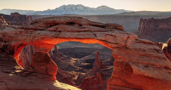
There’s a particular kind of altitude humility that sets in somewhere around mile two of your first Rocky Mountain National Park hike. You’re fit, you’ve hiked before, you’ve read the elevation warnings — and then the thin air taps you on the shoulder anyway. At 9,000 feet on a trailhead that would be a warm-up walk in your home state, your lungs ask politely for a moment. I’ve been coming to RMNP for years, and that recalibration still happens every single trip. It’s part of the park’s character: a place that rewards preparation and punishes overconfidence in roughly equal measure.
Rocky Mountain National Park covers 265,807 acres of north-central Colorado, straddling the Continental Divide between the east-side gateway town of Estes Park and the quieter west-side community of Grand Lake. Over 350 miles of trails range from paved lakeside loops to one of Colorado’s most-climbed fourteeners. Trail Ridge Road — the highest continuously paved through-road in the United States — crosses the park at elevations that exceed most peaks in the lower 48 states. Wildlife is abundant and visible. Permits are now required and genuinely complicated if you’re aiming for the Bear Lake corridor on a summer morning. All of it is worth understanding before you show up.
Estes Park vs. Grand Lake: Choosing Your Gateway
Most visitors arrive from the east via Estes Park, a busy mountain town with full lodging options, gear shops, and direct access to the park’s most-visited areas: Beaver Meadows Visitor Center, Bear Lake Road, and the east entrance to Trail Ridge Road. If you’re doing Bear Lake hikes, the Keyhole Route on Longs Peak, or elk-watching in Moraine Park — Estes Park is the correct base.
Grand Lake, on the west side, runs at a lower tourist volume and a different pace. It sits on Colorado’s largest natural lake and gives you direct access to the Kawuneeche Valley, the Colorado River headwaters corridor, and the western terminus of Trail Ridge Road. If your priority is moose, wildflower meadows, and solitude relative to the east-side crush, the west entrance deserves serious consideration. The one trade-off: you’re farther from the Bear Lake corridor and Longs Peak, which require either a long drive through the park or an overnight move.
A practical approach for longer trips is to split the visit — a few nights in Estes Park for the east-side highlights, then drive Trail Ridge Road and spend a night in Grand Lake to explore the west side properly before leaving. The full road crossing takes about two to three hours with stops, and doing it end-to-end rather than out-and-back makes the drive more memorable.
The 2024 Timed-Entry Permit System: What You Actually Need to Know
Rocky Mountain National Park introduced timed-entry permits during the COVID years and has continued them. For 2024, the system runs from late May through mid-October and requires advance reservations through recreation.gov. There are two distinct permit types, and conflating them is the most common planning mistake.
Park-wide timed entry covers access to all park areas except the Bear Lake Road Corridor. This includes Trail Ridge Road, the Alpine Visitor Center, and everything on the west side. Reservations are required for vehicle entry between 9 a.m. and 2 p.m. daily. Outside those hours, no permit is needed.
Bear Lake Road Corridor timed entry is a separate reservation that grants access to the most popular trailhead zone — Moraine Park, Sprague Lake, Glacier Gorge Trailhead, and Bear Lake — in addition to all other park areas. This corridor permit is required for entry between 5 a.m. and 6 p.m. daily, which effectively means you need it for almost any meaningful morning start at Bear Lake. The extended window exists because dawn photography and early hiking starts are heavily used here, and the corridor becomes gridlocked without managed entry.
Both permit types carry only a $2 non-refundable processing fee through recreation.gov on top of the standard park entrance fee. The $2 is not the expensive part — the challenge is availability. Permits open two weeks in advance on a rolling basis, with additional day-before allocations released the evening prior. If you’re planning a weekend Bear Lake sunrise, set a calendar alarm for two weeks out and grab that permit the moment it opens. Waiting until 48 hours out is a gamble you’ll frequently lose in July and August.
No permit is required if you’re arriving outside the reservation windows, staying in a park campground, or entering on foot or by bicycle.
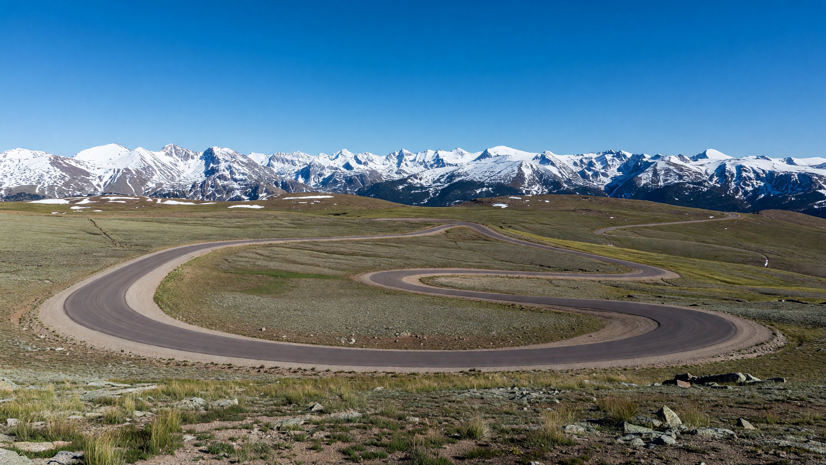
Trail Ridge Road: Driving the Rooftop of the Rockies
Trail Ridge Road is the park’s defining feature and the highest continuously paved through-road in the United States. The 48-mile route climbs from Estes Park at roughly 7,500 feet to a high point of 12,183 feet near Fall River Pass, staying above treeline for approximately 11 miles. On a clear day the views are operatic — an unbroken sweep of peaks, tundra, and sky that doesn’t look real until you’re standing in it.
The road typically opens fully by Memorial Day weekend, weather permitting, and closes with the first significant snowfall of autumn — usually sometime in mid-October, though the CDOT highway conditions page and the park’s recorded road status line (970-586-1222) are the authoritative sources for real-time status. Spring openings vary significantly year to year. Don’t plan a Trail Ridge drive for Memorial Day weekend without checking current conditions first; I’ve shown up on years when the road was still gated with three feet of snow at the summit.
The Alpine Visitor Center near Fall River Pass is open seasonally and worth the stop. It sits at 11,796 feet, making it one of the highest visitor centers in the National Park System, and the exhibits on alpine tundra ecology give useful context for what you’re seeing on the open road sections. The short Tundra Communities Trail from the nearby Rock Cut parking area is a 0.5-mile walk entirely above treeline — flat enough to be accessible, but at an elevation that reliably filters out the people who skipped the acclimatization advice.
For photography: the best light on Trail Ridge is either early morning (before the day-use crowds) or evening, when the low angle sun warms the tundra grasses and the shadows lengthen across the ridgelines. The Forest Canyon Overlook pull-out on the east side of the road is one of the park’s most undershot compositions — a nearly vertical drop of 2,500 feet into a U-shaped glacial valley that most visitors just photograph from the car window and drive past.
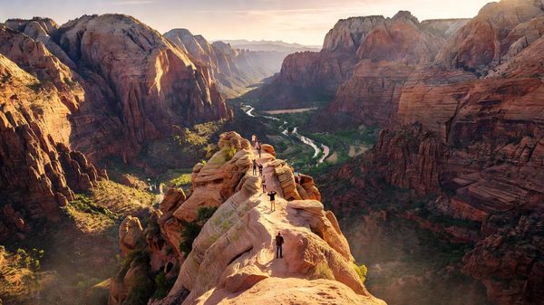
Bear Lake and the Eastern Trails Corridor
Bear Lake sits at 9,475 feet and functions as the park’s most popular trailhead hub. The paved 0.5-mile loop around the lake itself is flat, fully accessible, and genuinely beautiful — Hallett Peak’s reflection in the lake surface on a windless morning is the postcard image that launched a thousand Instagram accounts, and it earns the attention. But Bear Lake’s real value is as a launching point for the three-lake progression behind it.
Bear Lake to Emerald Lake is a 3.6-mile round trip that passes Nymph Lake and Dream Lake before reaching Emerald Lake at 10,080 feet. The elevation gain is modest (about 605 feet total), but it’s continuous and you feel it above 9,000. Dream Lake is the most photogenic of the three — Hallett Peak and Flattop Mountain frame the far shore in a composition that rewards a polarizing filter and at least 20 minutes of patient waiting for the wind to settle the surface. Most hikers rush through to Emerald Lake and miss the Dream Lake shot. Don’t be those hikers.
Sky Pond is a step beyond, reached by continuing past Emerald Lake on the Loch Vale trail and then scrambling up the Timberline Falls headwall. The round trip from Bear Lake runs approximately 9 miles with around 1,600 feet of elevation gain. Sky Pond itself sits at 11,040 feet in a glacially carved cirque below Taylor Peak — a striking place that sees far less traffic than the lower lakes simply because the scramble above Timberline Falls filters out casual hikers. The falls scramble is short (perhaps 100 vertical feet) but involves wet rock and exposed ledges; appropriate footwear is not optional.
Shuttle logistics: The Bear Lake Road Corridor permit doesn’t guarantee parking at Bear Lake — it only authorizes your vehicle to be in the corridor. The Bear Lake lot fills by 7 a.m. on peak summer weekends regardless of permit. The correct approach is to park at the Beaver Meadows or Glacier Basin transit hubs and take the free park shuttle to the Bear Lake trailhead. The shuttles run frequently during peak season and the rides are short.
Longs Peak: The Keyhole Route Caveat
Longs Peak is the park’s only fourteener at 14,259 feet, and the Keyhole Route is the standard approach. The NPS is fairly blunt about this: “The Keyhole Route is not a hike.” It’s a 15-mile round trip with roughly 5,100 feet of elevation gain, and the upper section — the Narrows, the Homestretch — involves exposed Class 3 scrambling on steep, loose rock where an unroped fall would be fatal. I say this not to discourage you but because the trail registers see a steady stream of people who read “most popular route on a fourteener” and assume that means accessible. It doesn’t.
No permit is required for day use on Longs Peak beyond your park entrance fee. The trailhead sits outside the timed-entry permit zone. The practical requirement is an extremely early start — most experienced Keyhole hikers are moving by 3 a.m. to 4 a.m., aiming to summit and descend below treeline before the afternoon thunderstorms that build almost daily in July and August. Lightning on the exposed upper ridges is not a recoverable situation.
If summiting isn’t your goal — or if you want to assess Longs Peak’s scale before committing — the hike to Chasm Lake is an outstanding 8.4-mile round trip that puts you directly beneath the peak’s dramatic 1,600-foot East Face. The technical climbing routes on that wall are some of the most serious alpine routes in Colorado. Worth seeing even if you have no intention of climbing them.
Wildlife: Elk Rut, Bighorn Sheep, and Moose
The park supports one of the largest elk herds in the United States, and the fall rut (mid-September through mid-October) is the most compelling wildlife event in the lower 48 states that most people haven’t attended. Mature bulls bugle from meadows at dawn and dusk — the sound is visceral in a way that no recording captures. Moraine Park and Horseshoe Park on the east side are the best-established viewing locations. The park posts seasonal schedules and ranger-led programs specifically around the rut.
Maintain at least 75 feet from elk at all times. Bulls during rut are genuinely dangerous — they charge vehicles, people, and each other without much additional provocation. The distance rule isn’t bureaucratic caution; it’s based on documented incidents.
Bighorn sheep are reliably seen on the rocky talus slopes visible from Trail Ridge Road, particularly near the Rock Cut pull-out and Sheep Lakes in Horseshoe Park. The sheep are remarkably habituated to human presence and will sometimes approach the road, which creates both excellent photo opportunities and a traffic management challenge. Pull completely off the road and don’t approach them.
Moose favor the willowed floodplains of the Kawuneeche Valley on the west side. The Coyote Valley Trail — a flat 1.8-mile round trip accessible to all mobility levels — is the most consistently productive moose-watching walk in the park. Early morning and late evening are the high-probability windows. Moose are significantly more unpredictable than elk; the 75-foot rule applies and they don’t give you much warning before a charge.
Photography: Bear Lake Sunrise, Trail Ridge Alpine, and Sprague Lake Reflection
Three compositions that reward the Bear Lake Road Corridor permit cost in a single morning:
Bear Lake sunrise is the park’s most iconic shot and remains worth doing despite its popularity. The window is narrow — maybe 20 minutes after first light when the sky above Hallett Peak goes pink and the lake surface is calm. By the time the sun clears the ridgeline, the light goes harsh. Get there early (the Bear Lake lot opens for permit holders at 5 a.m.), set up on the northeast shore, and shoot into the western face of Hallett Peak catching the alpenglow. A circular polarizer cuts surface glare when the sky brightens. Bring a tripod; the exposures at pre-dawn are long and the mirror effect disappears with any movement blur.
Trail Ridge alpine tundra shoots best in early July when the wildflowers are at peak. The tundra communities above 11,000 feet bloom in compressed, intense bursts — sky pilot, alpine sunflowers, and cushion phlox carpeting ground that looks barren from a distance. Wide-angle compositions work well here. The trick is getting low — almost ground level — so the flowers frame the distant peaks rather than vice versa. The Forest Canyon Overlook and the stretch of road between Rainbow Curve and Rock Cut are my preferred sections.
Sprague Lake reflection is a 45-minute walk from the Sprague Lake trailhead parking area via an accessible 0.5-mile loop. The lake’s perfectly flat surface and the classic RMNP skyline above it make for one of the park’s best dawn compositions. Unlike Bear Lake, the Sprague Lake lot doesn’t fill as aggressively, and the light angle works slightly later — you have more of the morning to shoot before the shadows go wrong. The paved loop means you can set up in multiple positions without scrambling.
High-Elevation Acclimatization
This section belongs near the top of any serious RMNP planning guide and gets underweighted in most of them. Estes Park sits at 7,522 feet — already higher than most US cities. Bear Lake is at 9,475 feet. Trail Ridge tops out at 12,183 feet. If you’re flying in from sea level and planning to hike to Sky Pond on day one, you’re going to have a bad time.
Acute mountain sickness (AMS) typically sets in above 8,000 feet in unacclimatized individuals and presents as headache, nausea, fatigue, and dizziness. It’s not a sign of poor fitness; it’s a physiological response to reduced oxygen availability that affects elite athletes and sedentary visitors alike. The standard advice — from the National Park Foundation and from the park itself — is to spend at least one night at moderate elevation (5,000–7,000 feet) before attempting strenuous high-altitude activity. If you’re flying into Denver (5,280 feet), that’s a reasonable intermediate step, but it’s still not acclimatization at park elevations.
Practical steps that actually help: arrive the day before your first major hike, stay well hydrated (not excessively, but consistently), avoid alcohol the first night, start with an easy walk at intermediate elevation, and if you develop a headache, descend rather than push through it. Ibuprofen addresses the symptom but doesn’t treat the underlying cause. Diamox (acetazolamide) is a pharmaceutical option worth discussing with your doctor for visitors who have previously had AMS; it requires a prescription and should be started before arrival.
For Trail Ridge Road driving specifically: you don’t need to be acclimatized to sit in a car at 12,000 feet, but getting out and walking around at altitude — especially rapidly ascending from Estes Park to the summit area — can trigger symptoms in some people. Take it slow. The Alpine Visitor Center benches exist for a reason.
Accessibility
The park has several excellent options for visitors with mobility limitations.
Bear Lake paved loop is a 0.5-mile fully accessible path around the lake with minimal grade change. The surface is paved and maintained. Hallett Peak and Flattop Mountain are visible throughout the loop, and the trail is genuinely scenic — not a consolation-prize accessible route.
Sprague Lake accessible loop is a flat, paved 0.5-mile loop around a picturesque lake. The same dawn reflection photography opportunity described above is available from the accessible trail.
Coyote Valley Trail on the west side is a flat 1.8-mile paved path with no significant obstacles — accessible and one of the best moose-viewing walks in the park.
Trail Ridge Road itself is fully driveable and all the major overlooks have parking and short paved paths to viewpoints. You can experience some of the park’s most dramatic scenery without leaving your vehicle if needed.
The park’s accessibility guide with detailed trail ratings is available through the official Rocky Mountain NP page on nps.gov.
Planning Your Visit: Practical Notes
Entry fees: The park charges $35 per vehicle (2024 rate) or is included in the America the Beautiful annual pass. The annual pass breaks even in two park visits and is worth it for anyone doing multiple national parks in a year.
Lodging: Inside the park, the YMCA of the Rockies and several lodges are just outside the boundaries in Estes Park. Moraine Park Campground and Glacier Basin Campground (both reservable through recreation.gov) are the primary in-park options. Campsite reservations in July and August open months in advance and go quickly.
Cell service: Spotty to nonexistent in most of the park. Download offline maps before you go. The park’s free shuttle app works offline.
Season: Late June through early September is peak season — all facilities open, all permits in effect, maximum crowds. Late September through mid-October is the elk rut window and arguably the best time to visit if Bear Lake photography isn’t your primary goal. Late May and early June have unpredictable weather and some trails still snow-covered, but the flower meadows begin to open and permits are easier to obtain. For a broader look at timing windows across the most-visited parks, the shoulder-season planning guide covers Trail Ridge Road closure dates and timed-entry transitions at Rocky Mountain alongside nine other parks.
For current permit availability, campsite reservations, and road conditions, recreation.gov and the NPCA Rocky Mountain page are worth bookmarking alongside the official park site. If you’re building a longer Great Plains and Rockies road trip, Badlands National Park in western South Dakota pairs naturally with Rocky Mountain — about six hours east, offering a completely different landscape character and one of the best wildlife recovery stories in the national park system.
Frequently Asked Questions
Do I need a permit to visit Rocky Mountain National Park in 2024? Yes. From late May through mid-October, a timed-entry permit is required for vehicle access between 9 a.m. and 2 p.m. A separate Bear Lake Road Corridor permit covers the Bear Lake area between 5 a.m. and 6 p.m. Both are obtained through recreation.gov for a $2 processing fee beyond standard park entrance fees.
What’s the difference between the Bear Lake Road permit and the regular timed-entry permit? The standard permit covers all park areas except the Bear Lake Road Corridor. The Bear Lake Road Corridor permit covers Bear Lake, Moraine Park, Glacier Gorge, and Sprague Lake — plus all other park areas. If Bear Lake hikes are on your agenda, you need the corridor permit, which is required from 5 a.m. to 6 p.m. daily.
When does Trail Ridge Road open and close? Typically Memorial Day weekend through mid-October, weather permitting. Opening dates vary significantly by year. Check CDOT’s cotrip.org or call the park road status line at 970-586-1222 before you go.
When is the elk rut at Rocky Mountain National Park? Mid-September through mid-October. Moraine Park and Horseshoe Park at dawn and dusk are the prime viewing spots. Keep 75 feet back — rutting bulls are genuinely dangerous.
Do you need a permit for Longs Peak? No permit beyond park entry is required for day hiking the Keyhole Route. The trailhead is outside the timed-entry zone. But “day hiking” is a loose term for a 15-mile, 5,100-foot technical scramble — start before 4 a.m. and be off exposed terrain before noon.
How hard is hiking here for sea-level visitors? Harder than expected. Even Bear Lake’s gentle trails start at 9,475 feet. Spend at least one night at elevation before strenuous activity, hydrate consistently, and descend immediately if headache or nausea sets in.
Is the park accessible for visitors with mobility limitations? Yes. The Bear Lake paved loop, Sprague Lake accessible loop, and Coyote Valley Trail are all fully accessible. Trail Ridge Road viewpoints have paved pullouts and short accessible paths.