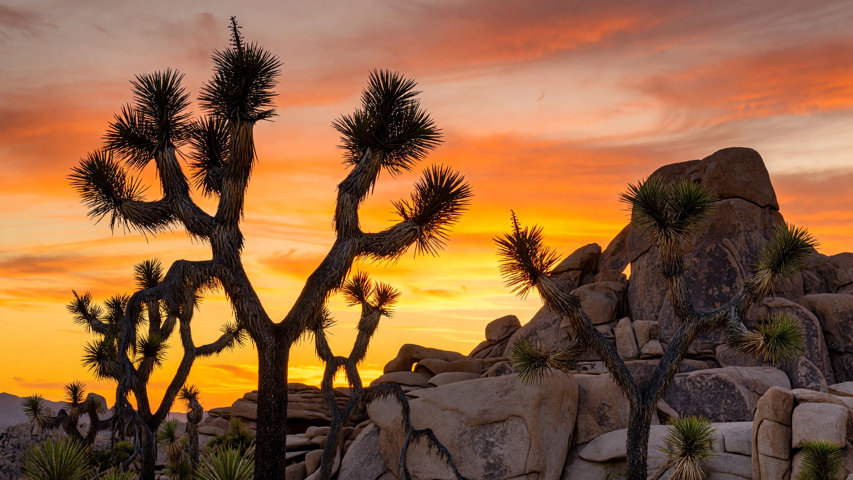
Two deserts meet inside Joshua Tree National Park, and that collision is the thing that makes this place genuinely unlike anywhere else in California. Drive west through the park and you’re in the Mojave — a high-elevation desert of boulder-scattered plateaus, cool nights, and dense forests of Yucca brevifolia, the Joshua tree itself. Drop toward the eastern lowlands and the Joshua trees thin and vanish, replaced by the hotter, sparser Colorado Desert: ocotillo in bloom, teddy bear cholla, and creosote stretching toward the Salton Sea basin. That transition happens gradually over a single park drive, and understanding it changes how you read the landscape.
I’ve been coming to Joshua Tree since my early twenties — first for the climbing, then increasingly for the photography — and the park still surprises me. It’s roughly 795,000 acres of federally protected Mojave and Colorado Desert, administered by the National Park Service and recognized internationally as an International Dark Sky Park by the IDA (darksky.org). At 2026, it’s also a park under measurable ecological pressure: the Joshua tree (Yucca brevifolia) is listed as a threatened species under the California Endangered Species Act, with climate modeling by the U.S. Geological Survey projecting significant range contraction across the Mojave as warming pushes the tree’s viable habitat to higher elevations. The park you visit today — these particular forests, at these particular densities — is worth documenting.
The Two-Desert Convergence: Mojave and Colorado
The dividing line between the two deserts runs roughly through the park’s center, following the 3,000-foot elevation contour. Above it: the Mojave, where Joshua trees grow in their characteristic forests. Below it: the Colorado Desert, the northernmost extension of the Sonoran Desert system, lower and hotter and distinctly different in its plant communities.
This dual-desert character is the ecological story the park tells better than anywhere else. The Cholla Cactus Garden — a dense stand of Cylindropuntia bigelovii (teddy bear cholla) just off Pinto Basin Road — sits squarely in Colorado Desert territory, and photographing it feels like photographing a different biome from the boulder fields ten miles northwest. The park’s biodiversity reflects this duality: species from both desert systems coexist and overlap in the transition zone in ways that aren’t found elsewhere.
The Joshua tree’s own biology depends on specific conditions: elevations between roughly 2,000 and 6,000 feet, cold winters to trigger bloom, and a now-disrupted relationship with the Yucca moth (Tegeticula spp.) as its primary pollinator. Older specimens in the park’s western reaches can reach 30 to 40 feet and carry hundreds of years of growth. Current climate stress means the park is already observing reduced seedling establishment in warmer, lower-elevation sections — a shift the U.S. Fish & Wildlife Service has flagged in ecological monitoring programs.
Three Entrances and How to Choose
Joshua Tree has three entrances, and which one you use shapes your entire day.
West entrance — Joshua Tree town (Highway 62 at Park Boulevard): This is the traditional approach for climbers and most first-time visitors. The West Entrance Station on Park Boulevard drops you directly into the high Mojave section — Joshua tree forests, Hidden Valley, and the primary climbing corridors are all accessible within minutes. The town of Joshua Tree (locally called “JT town”) immediately outside the entrance has the best concentration of gear shops, cafes, and last-chance water fills.
North entrance — Twentynine Palms (North Entrance Road off Highway 62): The Oasis of Mara Visitor Center in Twentynine Palms is the park’s main headquarters and the best place for current conditions, climbing ranger information, and interpretive exhibits. The Oasis of Mara itself — a true desert spring — is a short paved walk from the visitor center and supports a stand of California fan palms.
South entrance — Cottonwood (off I-10 near Chiriaco Summit): The Cottonwood Visitor Center entrance serves the Colorado Desert section and is the quietest of the three. This is the entry point for Cholla Cactus Garden and the Cottonwood Spring area. It’s the best approach if you’re coming from the Los Angeles basin via I-10 and want to experience the desert-to-Mojave transition driving north through the park.
Key Areas and What They Reward
Hidden Valley loop and nature trail (1 mile): The Hidden Valley Nature Trail is a one-mile loop through a boulder-enclosed basin that early settlers allegedly used to hide rustled cattle from view. From the trail, the surrounding monzogranite formations — boulders the size of apartment buildings, stacked and balanced by subsurface weathering over millions of years — are close enough to touch. This is also ground zero for sport and trad climbing: Intersection Rock, the Sports Challenge Wall, and dozens of named crags are visible from the trail. The loop is flat and suitable for all fitness levels; start early in warm months.
Keys View overlook: At 5,185 feet, Keys View is the park’s primary panoramic overlook, facing southwest over the Coachella Valley. On clear days you can identify the Salton Sea glittering to the southeast, the San Andreas Fault trace running through the valley floor, the Santa Rosa Mountains rising beyond Palm Springs, and — on exceptional winter mornings after coastal rain — the Mexican peak Cerro El Centinela near the Baja border. The drive from Park Boulevard to the overlook takes about 25 minutes on a paved road that passes through some of the densest Joshua tree terrain in the park. Sunset is superb; Keys View faces west and catches long directional light as the sun drops behind the San Jacinto ridge.
Skull Rock and Jumbo Rocks campground: Skull Rock, visible from Park Boulevard, is among the park’s most-photographed individual formations — a large rounded boulder weathered into a recognizable skull-like profile. The Skull Rock Nature Trail is a 1.7-mile loop that connects Skull Rock to the Jumbo Rocks area, wandering through boulder gardens and past native plants labeled for self-guided interpretation. Jumbo Rocks campground is the largest in the park at 124 sites and is among the most atmospheric — many sites sit directly against or between boulder formations, offering both shade and extraordinary nighttime sky access.
Cholla Cactus Garden: Off Pinto Basin Road in the Colorado Desert section, the Cholla Cactus Garden is a short (0.25-mile) paved path through a dense concentration of teddy bear cholla (Cylindropuntia bigelovii) — their silvery spines catch backlit morning sun in a way that photographs like nothing else in the park. This is a sunrise location. Come with a wide-angle or medium telephoto and arrive at least 20 minutes before sun-up.
Lost Horse Mine: The Lost Horse Mine Trail (4 miles round trip, 400 feet elevation gain) leads to one of the best-preserved gold and silver mining operations in Southern California, active in the late 1890s. The 10-stamp mill at the mine site is still standing. The trail passes through high Mojave terrain with consistent Joshua tree coverage and is one of the better half-day hikes in the park. Cultural history and landscape photography combine well here — the rusted mill machinery against boulder formations and open sky is genuinely compelling.
Barker Dam: The Barker Dam Trail (1.1 miles loop) leads to a small constructed reservoir built by early ranchers in the early 1900s to supply water for cattle. The reservoir surface often holds water in winter and early spring — and water in the desert means wildlife: bighorn sheep, coyotes, and numerous bird species use the area. There are also petroglyphs near the trail, though some were controversially repainted during a film production in the 1960s. The trail is an easy loop and is family-friendly.
Photography: Specific Locations and When to Be There
Joshua Tree is a photographer’s park — but generic “beautiful desert sunset” thinking misses most of the good frames. Here’s what I’ve learned through many visits.
Arch Rock — golden hour: Arch Rock, near the White Tank Campground at the end of a short (0.3-mile) spur trail, is an arched formation with a genuine opening large enough to frame the sky. Late afternoon in fall and winter catches warm directional light across the quartz monzonite surface. Use a wide-angle and include some foreground boulders to anchor the perspective. Allow 45 minutes total for the walk and setup.
Skull Rock — anytime: Skull Rock photographs well across a wide range of light conditions because of the formation’s strong directional shadows. Early morning and late afternoon are best for maximum texture on the weathered granite surface. The rock faces roughly south, so midday light flattens it. Overcast conditions work well because they eliminate harsh shadows while preserving the surface detail.
Cholla Cactus Garden — sunrise only: This is a one-time-of-day location. Backlit morning sun through the cholla’s silver spines creates a halo effect that disappears as soon as the sun rises above the low desert. Arrive before dawn, set up on the western edge of the garden facing east, and shoot at the moment the sun clears the Pinto Mountains.
Keys View — Salton Sea backdrop: The elevated view from Keys View combines several photographic elements that don’t appear together anywhere else in Southern California: the agricultural geometry of the Coachella Valley floor, the silver sheet of the Salton Sea, the fault-trace mountains, and Joshua trees in the foreground if you recompose slightly away from the main viewpoint. Telephoto compression (200mm equivalent or longer) collapses the valley floor and brings the sea closer. Shoot in the 20-30 minutes before sunset for best color.
Dark sky and stars: Joshua Tree carries International Dark Sky Park designation from the IDA — recognition of light pollution levels low enough for naked-eye Milky Way viewing on moonless nights. The park’s distance from Los Angeles, Palm Springs, and San Diego creates a buffer that preserves sky quality. Best conditions: new moon, October through April (avoid summer for comfort), after astronomical twilight. The Astronomical Society of the Desert hosts public star parties in the park several times a year — dates are posted on the NPS website and are worth planning around if you’re new to astrophotography. For night exposures, Jumbo Rocks and Skull Rock both work well; Arch Rock is excellent if you can get there in the dark.
The quartz monzonite granite that makes up Joshua Tree’s boulder formations has a distinctive crystalline surface texture that holds light differently from volcanic or sedimentary rock — it sparkles minutely under directional sun and produces warm, almost golden tones at golden hour. That quality is specific to this geology and is part of what makes the park so photographically distinctive.
Climbing: 4,500+ Routes on Quartz Monzonite
Joshua Tree is one of the world’s premier rock climbing destinations. The park contains more than 8,000 established climbing routes and 2,000 boulder problems across hundreds of documented formations — a density of technical terrain that has shaped an entire climbing subculture centered on the Twentynine Palms–Joshua Tree corridor. Climbers come from across the country and internationally, and the campgrounds around Hidden Valley and Indian Cove fill with climbers every weekend from October through April.
The rock is quartz monzonite — a coarse-grained intrusive igneous rock that weathers into the rounded, friction-positive surfaces climbers prize. Crack quality is generally excellent. Routes range from beginner-friendly slab climbs through sustained technical crack systems to serious multi-pitch lines on the larger formations.
Top climbing areas:
Hidden Valley and Real Hidden Valley: The primary focus area for most visiting climbers. Dozens of crags clustered within easy hiking distance of the Hidden Valley Campground. Intersection Rock alone contains 50+ routes at various grades. The Real Hidden Valley, a short walk through the formation maze, is quieter and contains some of the park’s finest crack routes.
Echo Cove: A quieter sector east of the main Hidden Valley complex, with fewer crowds and routes that trend toward the intermediate-to-advanced range. Good early-morning sun access in fall and winter.
Indian Cove: On the park’s northern boundary, Indian Cove is a separate campground and climbing area with a distinct character — blocky formations, shorter routes, and excellent access for families and beginners. Its location slightly outside the main park corridor means it’s sometimes less crowded than Hidden Valley on peak weekends.
Bouldering at Outback and Hemingway: The Outback area south of Hidden Valley contains concentrated bouldering on low-to-ground formations with a wide grade range. Hemingway Buttress offers excellent single-pitch routes and boulder problems. Both see consistent use from the local climbing community.
The park maintains dedicated climbing rangers who are knowledgeable about conditions, route closures for raptor nesting, and access issues. Check at either the Oasis Visitor Center (Twentynine Palms) or the Hidden Valley area for current closures. The American Alpine Club publishes resources for Joshua Tree climbing including gear recommendations and grade conversions for visitors arriving from areas that use different rating systems.
Timing: Dawn and dusk are strongly preferred for friction-dependent climbing on quartz monzonite. The rock heats significantly under full sun, reducing friction on slab routes and making crack climbing more taxing. In October through March, mid-morning through mid-afternoon can be excellent; in April and May, the morning window narrows quickly. Summer climbing is possible before 9 a.m. and after 5 p.m., but the midday heat makes it genuinely uncomfortable and can be dangerous.
Family Visits: Junior Ranger Program
The NPS Junior Ranger program is well-suited to Joshua Tree’s interpretive themes. Kids work through activity booklets available at any visitor center — covering desert ecology, geology, Leave No Trace principles, and wildlife — and earn a badge upon completing activities and checking in with a ranger. The program runs year-round and has age-differentiated booklets (younger children get simpler tasks; older kids and teens have more demanding material). The Oasis Visitor Center in Twentynine Palms is the best location to start a family visit, with indoor exhibits, a bookstore, and a short paved trail to the Oasis of Mara palms.
The Cap Rock Nature Trail — a paved 0.4-mile loop accessible from the parking area without steps or significant grade change — and the Keys View parking lot (accessible by vehicle, with a paved path to the main overlook) are the two most accessible features for visitors with mobility limitations.
Seasonal Reality: When to Come and When to Stay Home
October through April: These are the months Joshua Tree is designed to be visited. Daytime highs range from the 50s to the low 80s in most of the park, nights can be cold (bring warm layers for October, November, and February), and the combination of clear air and lower sun angles makes the light extraordinary for photography. Spring bloom — triggered by winter rainfall, variable by year — can be spectacular from late February through mid-April. The park is busiest on weekends from October through December and from February through April; plan weekday visits or arrive very early if possible.
May through September — serious heat warning: The lower elevations of Joshua Tree regularly exceed 100°F from June through August, and the Colorado Desert section can approach 110°F. Heat-related illness kills visitors in the Mojave and Colorado deserts every year, and Joshua Tree is no exception. The NPS requirement of one gallon of water per person per day is a genuine minimum — in summer, active hiking in direct sun demands significantly more. Shade is scarce. Many visitor center staff will actively advise against strenuous activity between approximately 10 a.m. and 4 p.m. during summer months.
If you must visit in summer: arrive before dawn, complete any hiking before 9 a.m., retreat to air-conditioned vehicles and visitor centers during midday, and carry far more water than you think you need. The North Entrance Oasis Visitor Center is the primary water filling point inside the park; there is no potable water on the main park road between the two visitor center complexes.
Comparing the desert heat protocols between Joshua Tree and Death Valley National Park is instructive — Death Valley is more extreme in absolute temperature, but Joshua Tree’s heat is no less serious for the unprepared.
Gateway Towns
Joshua Tree town: The western gateway, most popular with the climbing community. Grocery store, gear shop (Nomad Ventures on Park Boulevard), numerous restaurants and cafes, short-term vacation rental inventory. The town has developed a distinct bohemian-artist-climber identity over the past two decades that makes it a genuinely interesting place to base a trip.
Yucca Valley: The larger commercial hub on Highway 62, about seven miles west of Joshua Tree town. Big-box retailers, gas stations, a hospital (High Desert Medical Center), chain hotels, and the most complete supply options if you’re doing a multi-day camping trip and need to stock up. Less atmospheric than JT town but more practical for logistics.
Twentynine Palms: The eastern gateway, home of the park’s main visitor center and headquarters. Smaller commercial strip than Yucca Valley, with a significant Marine Corps presence (the 29 Palms Air Ground Combat Center is the largest Marine Corps base in the United States). Hotel and restaurant options have improved in recent years. Closest access point to the Oasis Visitor Center, Indian Cove, and the park’s northern climbing areas.
The Mojave Desert Land Trust (mojavedesertlandtrust.org) manages conservation lands adjacent to the park’s boundaries and is a legitimate resource for understanding the broader ecological context of Joshua Tree’s landscape — including the connectivity corridors between the park and the wider Mojave.
Frequently Asked Questions
How big is Joshua Tree National Park? Joshua Tree covers approximately 795,155 acres — roughly the size of Rhode Island. The park spans parts of San Bernardino and Riverside counties in Southern California.
What two deserts meet in Joshua Tree? The Mojave Desert occupies the park’s higher western elevations, where Joshua trees grow. The Colorado Desert — the westernmost extension of the Sonoran Desert system — covers the lower eastern portion. The two ecosystems meet in the park’s central section, creating a transition zone with unusually high plant diversity.
Is Joshua tree (Yucca brevifolia) really threatened? The Joshua tree is listed as a threatened species under the California Endangered Species Act. Climate projections indicate that warming temperatures will progressively compress the species’ viable range to higher elevations, potentially eliminating Joshua trees from the lower portions of the park within decades under high-emissions scenarios.
How many climbing routes are in Joshua Tree? The park contains more than 8,000 documented climbing routes and 2,000 boulder problems, per NPS data. The guide published through Maximus Press (Stone and Sky by Randy Vogel) is the authoritative print route reference. The NPS climbing website at nps.gov/jotr also provides current access and closure information.
Is Joshua Tree really a Dark Sky Park? Yes. Joshua Tree holds International Dark Sky Park designation from the IDA (International Dark-Sky Association). The designation recognizes the park’s low light pollution levels and the NPS’s commitment to maintaining dark sky conditions. The Milky Way is typically visible to the naked eye on moonless nights from October through April.
What is the single most important thing to know about summer visits? Carry a minimum of one gallon of water per person per day — and plan your activity hours for very early morning. Heat-related emergencies are common in summer. Many experienced desert visitors consider June through September off-season for good reason.
Which entrance is best for climbers? The West Entrance (Joshua Tree town) gives the fastest access to Hidden Valley, the primary climbing complex. Most visiting climbers stay at Hidden Valley Campground, which fills quickly on fall and spring weekends. Indian Cove, accessed from Highway 62 east of Twentynine Palms, is a secondary climbing area with its own campground.
Further reading: NPS Joshua Tree · National Parks Conservation Association · International Dark-Sky Association · American Alpine Club