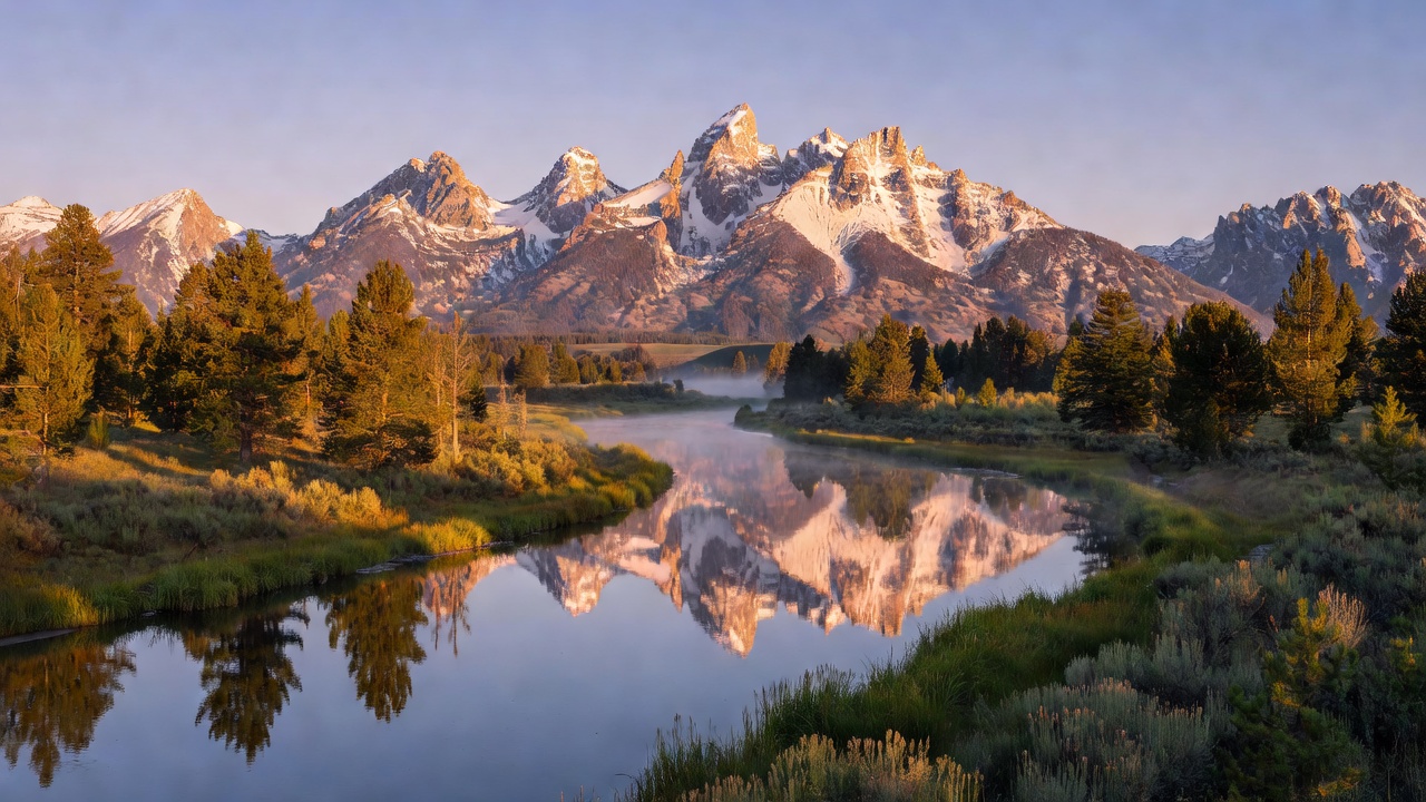
The first time I drove into Grand Teton, I didn’t see the mountains coming. I was on US-26 coming north from the Jackson airport, and then I crested a small rise and there they were — the entire Teton Range erupting from the valley floor without warning, without the gradual buildup of foothills that you get with almost every other mountain range in North America. The Tetons are geologically one of the youngest ranges on the continent, and that youth is visible: the fault block that forms the range is still rising, still being carved by glaciation, and it has not yet had time to develop the gentler approaches that erosion usually produces over millions of years. The result is a wall of bare granite that rises approximately 7,000 feet above the Jackson Hole valley floor in one continuous escalation — the Grand Teton itself at 13,775 feet, flanked by Mount Owen, Teewinot, and Mount Moran — and you see all of it at once, the full vertical, from the flats.
Grand Teton National Park protects approximately 310,000 acres of that range and the surrounding Jackson Hole valley ecosystem. It is a compact park by Western standards — smaller by a factor of seven than its northern neighbor Yellowstone — but that compactness is one of its strengths. A fit traveler with five days can realistically hike the major trails, hit every significant photography location, float the Snake River, and still have time to explore the northern areas near Colter Bay. Most visitors combine Grand Teton with Yellowstone National Park, which sits roughly 45 miles to the north, connected via the John D. Rockefeller Jr. Memorial Parkway.
Getting Oriented: Jackson Hole and the Two Parallel Routes
Jackson Hole is not a town — it’s the valley. The town is Jackson, located about 13 miles south of the park’s Moose entrance and roughly 55 miles south of Moran Junction at the park’s northern edge. Jackson has everything a gateway town should: lodging across all price points, gear shops, outfitters offering float trips and guided hikes, the Jackson Hole Airport (JAC) with direct flights from a dozen cities, and enough restaurants to keep a week-long trip interesting.
There are two main routes running north-south through or along the park, and understanding how they relate is the first planning decision you’ll make.
Teton Park Road (also called the Inner Park Road) runs 42 miles along the base of the mountains from the Moose Entrance in the south to Moran Junction in the north, passing the String Lake area, Jenny Lake, Signal Mountain, and Jackson Lake Lodge. This is the scenic route for park-focused travelers — it’s where the trailheads, pull-outs, and front-country campgrounds are, and where the mountain walls are most immediately present. In peak season (late June through Labor Day), sections of Teton Park Road require a timed-entry or vehicle reservation through the park’s system; check current requirements at the official NPS site before you go.
US-26/89/191 is the through-highway that parallels Teton Park Road to the east, running through the valley floor across the sagebrush flats and near the Snake River corridor. It’s the faster route if your destination is Yellowstone — but it also passes the turnoffs for Mormon Row and the Antelope Flats area, and the Snake River Overlook is right on this highway. Drivers connecting through to Yellowstone without a full park pass take this route; it’s also where a lot of the best wildlife watching happens because the open flats are hunting and grazing habitat.
Jenny Lake: The Park’s Hub
Jenny Lake is the gravitational center of Grand Teton. It sits at the base of Cascade Canyon, a clear cold glacial lake at the foot of some of the steepest mountain terrain in the park, and it serves as the trailhead for the most popular hikes, the main visitor center for the south end of the park, and the location of Jenny Lake Lodge (the park’s premium in-park accommodation). On a summer morning, the Jenny Lake Visitor Center parking lots fill before 8 a.m. and don’t clear. Arrive early or plan to use the overflow areas and walk in.
The most-visited experience in the park is the hidden falls and Inspiration Point hike, accessed via the Jenny Lake shuttle boat. The shuttle crosses the lake from the east shore landing to the west shore, cutting the walk to Hidden Falls from a 4-mile round trip to roughly 2 miles round trip. Hidden Falls drops about 200 feet in a series of cascades into a rockfall basin — a satisfying destination on its own. From there, the trail climbs steeply another quarter mile to Inspiration Point, a rocky promontory with a direct view down into the Jenny Lake basin and across the valley. The shuttle operates seasonally, typically from late May through late September — check current schedules with the visitor center, as the dates shift with snowpack and water conditions. The boat costs a small fee per round trip.
The walk around the lake (about 7 miles) is worth doing if you have time — the western shoreline section passes through old conifer forest with views back across the water to the Teton peaks.
Bradley and Taggart Lakes: The Overlooked Alternative
While Jenny Lake draws the crowds, the Bradley and Taggart Lakes loop offers a genuinely comparable experience with a fraction of the traffic. The trailhead is at the Taggart Lake parking lot off Teton Park Road, about 3 miles south of the Jenny Lake turnoff. The standard loop — Taggart Lake outbound, Bradley Lake return via the moraine ridge — runs approximately 5.5 miles with around 400 feet of elevation gain. Both lakes sit in glacially carved basins beneath the same wall of peaks that defines the rest of the park, with moraine fields, lodgepole pine forest, and views of the Teton faces close enough that you can make out individual cliff bands and snowfields.
This is the hike I consistently recommend to photographers who want foreground variety. The trail passes through burned forest from the 1985 Beaver Creek Fire and its successional vegetation — wildflowers in early summer (late June is exceptional), changing aspen color in late September and early October. It’s a 3–4 hour hike at a moderate pace, fully doable for a half-day without the Jenny Lake shuttle crowd logistics.
Cascade Canyon: The Park’s Backcountry Entry Point
For visitors ready to push deeper into the range, Cascade Canyon is the classic route. The trail begins at the west shore of Jenny Lake (the shuttle boat or the lakeshore walk brings you to the west shore trailhead), then follows Cascade Creek up into a glacially carved U-shaped valley between the walls of Teewinot and Mount Owen on the left and the south face of the Cathedral Group on the right. The geology is on full display here in a way that is difficult to see from the valley floor: the scale of the vertical relief, the raw granite, the evidence of glaciation in the hanging valleys and polish marks on the rock walls.
The trail to the Forks of Cascade Canyon — where the valley splits into the North Fork (leading toward Lake Solitude) and the South Fork (toward Hurricane Pass) — is approximately 9 to 10 miles round trip from the west shore, gaining roughly 1,000 feet. This is the standard out-and-back that makes a full day trip. For hikers with a backcountry permit, the route continues to Lake Solitude (North Fork, roughly 14.5 miles round trip from the west shore) or over Hurricane Pass into the Death Canyon drainage (South Fork — the basis for the Death Canyon–Cascade Canyon horseshoe loop, one of the park’s great overnight circuits). Backcountry permits are obtained through Recreation.gov in advance or at the Jenny Lake permit station in person.
The Photography Locations: Where Every Shot Comes From
Grand Teton has four photography positions that show up in nearly every serious landscape collection of the American West. If you’re making the trip specifically with a camera, these are not optional.
Schwabacher Landing is where the Snake River forks into braided channels through willow-lined banks, creating a still-water reflection pool that mirrors the Cathedral Group at sunrise. The light arrives on the mountains before it reaches the valley floor, so for 20 to 30 minutes at first light the peaks are lit gold above a dark valley with a perfect inverted reflection in the water. Getting this shot means arriving 30–45 minutes before sunrise and using a tripod — the light level before the sky ignites is too low for handheld work at any focal length you’d want to use. The access road to Schwabacher Landing is a gravel spur off US-26/89/191, about 4 miles north of Moose. It’s also one of the most reliable moose habitat locations in the park — the willows along the braided channels are exactly the saturated, shrubby habitat that moose prefer, and I have never visited Schwabacher at dawn without seeing at least one.
Oxbow Bend is a tight meander of the Snake River at the northern end of the park near Moran Junction where the mountain reflection frequently appears in the still, slowed water of the outside curve. On clear mornings, the entire Cathedral Group and Mount Moran reflect in the oxbow. This is also where beavers are active — look for their lodges in the willows along the far bank — and where great blue herons, white pelicans, and osprey work the shallows. The parking area is just east of Jackson Lake Junction on the main highway. Oxbow benefits from a wide-angle lens: the full reflection extends across a long horizontal plane, and a 24mm or wider captures both the peaks and their mirror simultaneously.
Mormon Row is not technically inside the park boundary — the historic district of homestead buildings sits on Antelope Flats Road, accessible from a turnoff on US-26/89/191 about 2 miles north of Moose Junction. The Moulton Barns — the Т.A. Moulton barn and a second Moulton-era structure nearby — are the subjects of what is probably the single most widely reproduced photograph composition in the American West: weathered homestead barns with the full Teton Range rising directly behind them. The barns are most striking in morning light (east-facing in the morning, so the facades are lit) with the mountains still catching alpenglow. Late afternoon reverses the situation — the mountain faces are lit but the barns fall into shadow. Wild bison from Antelope Flats herd frequently graze within composition distance of the barns; in September the flat golden grasses add foreground texture that summer doesn’t provide.
Snake River Overlook is Ansel Adams’ composition — the viewpoint from the elevated western bank where Adams made the 1942 photograph that defined how the world pictures Grand Teton. The pull-out is on US-26/89/191 about 11 miles north of Moose, with a short walk to the overlook bluff above the river’s east-bending curve and the full mountain range behind it. The iconic Snake River bend is visible below. In Adams’ era the cottonwood trees along the river were shorter; today they fill the frame more and the composition requires more careful lens selection. The view is still extraordinary and still recognizable. Dawn and dusk both work here, though the peaks face west so afternoon light illuminates the faces more directly.
Wildlife: What You’ll See and Where
Grand Teton sits within the Greater Yellowstone Ecosystem, which means the wildlife portfolio here is not incidental — it’s one of the primary reasons to visit. The park supports both grizzly bears and black bears (the northern sections toward Moran Junction and Colter Bay see more grizzly activity; black bears range throughout the park), moose along virtually every willow-lined watercourse, elk in the Antelope Flats and upper Cascade Canyon meadows, and bison herds on the sagebrush flats. The National Elk Refuge immediately south and east of Jackson — the winter range for the Jackson Hole elk herd — pushes elk into the park’s southern sections in summer.
In the Snake River corridor and at Schwabacher Landing specifically, beavers are active year-round — the dams and lodges in the braided channels are obvious from the landing, and the beavers themselves are most visible at dawn and dusk. The flat water that creates the famous photography reflection is partly a result of beaver activity slowing and spreading the flow.
Pronghorn move through the Antelope Flats at speed — faster overland than any other animal in North America at sustained pace — and the open sagebrush flat framed by mountains is one of the more striking wildlife-photography compositions in the park if you have a long lens. Sandhill cranes nest in the wetland margins in early summer.
Standard bear safety protocols apply throughout the park: carry bear spray in any backcountry or lakeshore setting, store food in designated bear boxes at campsites, and observe the 100-yard minimum distance for bears. The park requires bear spray for overnight backcountry travel.
Colter Bay and the Northern Park
Colter Bay Village on the north shore of Jackson Lake functions as the service hub for the northern park — full campground, cabin lodging, marina, restaurant, and a visitor center that houses one of the park system’s better exhibits on the Native American cultures historically connected to the Jackson Hole region. The Indian Arts Museum at the Colter Bay Visitor Center has a significant collection worth an hour regardless of your level of interest in the history.
Jackson Lake itself is the largest body of water in the park, an originally natural lake that was expanded by the early-20th-century Jackson Lake Dam at its outlet. Boating, fishing, kayaking, and canoe rentals are available through the Colter Bay marina. From Signal Mountain — a 5-mile paved road climbing about 800 feet above the valley floor to a summit viewpoint — the entire Jackson Hole valley and Teton Range are visible simultaneously in a way that no single valley-floor location matches. Alpenglow from the Signal Mountain summit, with the shadow of the mountains extending across the flat valley at sunset, is one of the park’s underrated photography targets.
Climbing: What Grand Teton’s Summits Actually Require
Grand Teton’s peaks are photographed by millions of people a year. Summited by a small fraction. The distinction is worth understanding clearly.
The Grand Teton at 13,775 feet is a technical alpine climb requiring glacier travel and rock climbing skills. The standard route — the Upper Exum Ridge — involves multiple pitches of 5th-class rock climbing. The Owen-Spalding Route, the other standard ascent, involves lower-angle terrain but still requires glacier travel on the Lower Saddle snowfield and route-finding that is not intuitive for non-climbers. There are no trails to the summit. The lower saddle (11,600 feet) is accessible by the non-technical approach, and from a distance the upper mountain looks closer than it is, but the technical difficulty increases sharply above it.
Two NPS-authorized guide services operate in the park: Exum Mountain Guides and Jackson Hole Mountain Guides. Both run guided ascents of the Grand Teton and other peaks in the Cathedral Group, offering instruction courses that precede summit attempts for climbers without prior alpine or rock experience. If a Grand Teton summit is on your list and you don’t already climb at the required grade, booking a guided course is the legitimate path. The American Alpine Club’s Climbers’ Ranch inside the park provides affordable bunkhouse lodging for climbers doing routes on the range — a long-standing institution for the climbing community.
Water: Floating the Snake River
The Snake River below Jackson Lake Dam through the park is floatable by non-motorized and motorized watercraft with a float permit, and several NPS-authorized concessioners offer guided float trips. The most popular is the scenic float — a 5-mile drift through the braided channels of the Snake with constant mountain views and reliable wildlife watching along the banks. This is not whitewater rafting; the in-park section is calm water, suitable for all ages. Guided trips typically run 1.5 to 2 hours and depart from the Triangle X or Barker-Ewing launch points. If Schwabacher Landing is the photographer’s approach to the Snake River corridor, the float trip is the naturalist’s — you’re at water level, moving silently through the willows, and moose and beaver are frequent.
The section of the Snake River south of the park through the Jackson Hole valley and into Snake River Canyon becomes increasingly technical as you move downstream; the Canyon section south of Hoback Junction is Class III-IV whitewater territory run by separate outfitters out of Jackson.
Jackson Hole Mountain Resort: Neighbor, Not Concessioner
Jackson Hole Mountain Resort operates on Rendezvous Mountain in the town of Teton Village, about 12 miles northwest of Jackson and just outside the park’s southwestern boundary. It is a private operator, not an NPS concessioner, and Rendezvous Mountain is not part of Grand Teton National Park — the boundaries are adjacent but distinct. In summer the resort operates the Aerial Tram to the 10,450-foot summit of Rendezvous Mountain, from which the Teton Range, Jackson Hole valley, and on clear days the Snake River drainage across into Idaho are all visible. This is not a park experience in any official sense, but it is a legitimate viewpoint addition to a Grand Teton trip for visitors who want an elevated perspective without a technical climb.
The ski mountain itself — one of the largest vertical drops in North America at 4,139 feet — operates December through April and is where Jackson Hole’s winter tourism economy concentrates, though that operation sits entirely outside the park.
Seasonal Planning
June through early July is my preferred window for landscape photography. The snow on the Teton peaks is still heavy enough to provide contrast, the wildflowers on the moraine trails (Bradley/Taggart, the lower Cascade Canyon meadows) are at their peak, and the days are at maximum length. The downside is that the Jenny Lake area reaches its crowd peak in July — parking and trailhead logistics require very early starts.
August is reliable and warm. The snow is retreating from the upper peaks (visible in the comparison of the mountain faces) but the summer wildflowers are still holding in the higher meadows. Full services across the park.
Mid-September to early October is arguably the most rewarding single-window visit. The elk rut begins in mid-September — bulls bugling across the valley at first light, sparring in the Antelope Flats and meadows near the Snake River corridor. Crowds drop sharply after Labor Day. Aspen color in the moraine zones and along the lower canyon approaches typically peaks the last week of September. The photography light is lower-angle and warmer than summer.
Winter closes Teton Park Road north of the Taggart Lake Trailhead to motor vehicles; that section is groomed for cross-country skiing and snowshoeing. The southern end of the park remains accessible by road. Moose remain active and visible along the Snake River corridor all winter; the snow on the Teton faces is at its most photogenic. Jackson Lake Lodge and most in-park lodging closes for the season; lodging falls back to the Jackson gateway.
Accessibility
Several of the park’s best experiences are meaningfully accessible. The Jenny Lake Visitor Center area has paved paths to the lakeshore viewpoints. The Colter Bay Visitor Center and its shoreline paths are accessible by wheelchair. The String Lake picnic area has accessible facilities and a short accessible path to the lakeshore. Snake River float trips with several concessionaires accommodate mobility-limited visitors; confirm specifics with individual operators when booking. The Mormon Row barns are accessible via the flat gravel road that runs the length of the historic district — no significant grade.
The challenging terrain in the park — Cascade Canyon, the Bradley/Taggart loop, and the upper mountain — is not accessible without significant off-trail ability, but the viewpoints, photography positions, and lakeshore areas provide a full park experience without them.
Planning Your Trip: Logistics
The Moose Entrance (south) connects to Jackson via US-26/89/191 — from Jackson, it’s about 13 miles north to the Moose Visitor Center, which is the primary planning stop for first-time visitors. The Moran Entrance (north) is the logical entry point for travelers arriving from Yellowstone.
Summer vehicle reservations or timed-entry windows may apply on Teton Park Road in peak season — check the current policy at nps.gov/grte before your trip, as these systems have evolved in recent years and vary by section of road. The standard NPS America the Beautiful annual pass covers entry to both Grand Teton and Yellowstone, which makes the pass economical for a combined trip.
Camping reservations at Jenny Lake (the tent-only campground is the most popular in the park), Signal Mountain, and Gros Ventre open on Recreation.gov and fill quickly for peak summer dates. The Gros Ventre campground, slightly south of the park near Kelly, is the largest and most likely to have same-week availability in summer.
Frequently Asked Questions
How large is Grand Teton National Park? The park covers approximately 310,000 acres, encompassing the Teton Range, Jackson Hole valley floor, Jackson Lake, and portions of the Snake River corridor. It is connected to the north via the John D. Rockefeller Jr. Memorial Parkway to Yellowstone’s south boundary.
How far is Grand Teton from Yellowstone National Park? The drive from Grand Teton’s Moran Entrance to Yellowstone’s South Entrance via the Rockefeller Parkway is approximately 40 to 45 miles, taking about 45 to 60 minutes depending on traffic and wildlife encounters on the road. Most visitors combine both parks in a single trip of 5–7 days minimum.
Can you hike to the top of the Grand Teton? The Grand Teton summit at 13,775 feet requires technical rock climbing and glacier travel — it is not a hiking destination. The standard routes (Upper Exum Ridge, Owen-Spalding) involve multiple pitches of 5th-class rock. NPS-authorized guide services Exum Mountain Guides and Jackson Hole Mountain Guides offer guided ascents and instruction courses for those without prior technical experience.
What is the best hike for first-time visitors? The Jenny Lake shuttle boat to Hidden Falls and Inspiration Point is the classic first-timer choice — a full mountain experience in a half-day. For visitors who want a quieter equivalent, the Bradley and Taggart Lakes loop (5.5 miles from the Taggart Lake Trailhead) delivers comparable terrain and mountain views with fewer crowds.
When is the best time to photograph at Schwabacher Landing? Arrive 30–45 minutes before local sunrise for the best combination of mountain alpenglow and Snake River reflection. A tripod is required for the pre-dawn light levels. The still-water reflection disappears once wind picks up, typically within an hour of sunrise.
Is Grand Teton National Park good for wildlife viewing? Yes — the park hosts both grizzly and black bears, moose (concentrated along the Snake River corridor and in willow wetlands), bison herds on Antelope Flats, elk, pronghorn, beavers (Schwabacher Landing and Oxbow Bend), and a wide variety of birds including osprey, bald eagles, and great blue herons. The Greater Yellowstone Ecosystem context means wildlife diversity here rivals anywhere in the lower 48 states.
What is the difference between Teton Park Road and US-89/26/191? Teton Park Road is the scenic inner route running close to the mountain base with access to all major trailheads, campgrounds, and the Jenny Lake area — the route for park-focused visitors. US-26/89/191 is the parallel through-highway on the valley floor, faster for through-traffic to Yellowstone, and the road that passes Snake River Overlook, the Mormon Row turnoff, and the Antelope Flats wildlife area.
For current road conditions, timed-entry requirements, and campsite reservations, check the official Grand Teton National Park page on nps.gov. For campground and backcountry permit bookings, visit Recreation.gov. For conservation context and park policy updates, the National Parks Conservation Association covers the Greater Yellowstone Ecosystem. For geology background on the fault-block Teton uplift, the USGS Geology of Grand Teton National Park provides peer-reviewed reference material. Grand Teton’s String Lake and Jackson Lake paddling options are covered in the national parks kayaking and canoeing guide.