The first time I drove Going-to-the-Sun Road end to end, I pulled over at every possible turnout — not because I was lost, but because stopping felt mandatory. Fifty miles of two-lane mountain road carved through the northern Rockies, cresting at Logan Pass before descending toward the Great Plains on the east side. By the time I reached St. Mary Lake at the road’s eastern terminus, I had burned most of a day and was already planning the return trip. Glacier National Park earns its reputation without trying hard, but knowing how to navigate it — when to arrive, where to linger, what the logistical realities actually look like in peak season — makes the difference between a transformative trip and a frustrating crawl behind RVs.
This guide is built around the Road as the central axis, because for most first-time visitors that is exactly what it is. Every major decision — where to stay, which trailheads to prioritize, when to leave the car — flows from how you approach Going-to-the-Sun.
The Park at a Glance: Scale and Context
Glacier spans roughly 1.0 million acres along the Montana-Canada border, sharing a boundary with Canada’s Waterton Lakes National Park to the north (together they form the Waterton-Glacier International Peace Park, a UNESCO World Heritage Site). The Continental Divide bisects the park, meaning the western slope catches Pacific moisture while the east side sits in the rain shadow — two distinctly different ecosystems within the same boundary.
The park holds approximately 25 named active glaciers today, down from an estimated 150 in 1850. The loss is stark and measurable: scientists at the U.S. Geological Survey and universities across Montana have been documenting glacier retreat through repeat photography for decades, and the images are definitive. What you are walking toward on the Grinnell Glacier trail is smaller than what your grandparents would have found, and what your children find will be smaller still. That impermanence doesn’t diminish a visit — if anything, it sharpens attention.
The park maintains over 700 miles of maintained trails. That number is almost abstractly large for a first-time visitor trying to plan a long weekend. The practical reality: the Road corridor and the Many Glacier valley contain the routes most people have time for, and both reward deep attention rather than breadth.
Going-to-the-Sun Road: The 50-Mile Spine
The Road runs west-to-east from Apgar at the foot of Lake McDonald to St. Mary at the eastern edge of the park — 50 miles total, crossing the Continental Divide at Logan Pass (6,646 feet). It was completed in 1932 after over a decade of construction, blasted through mountainside on grades that still feel audacious a century later. The National Historic Landmark designation is well-earned.
Opening season: The Road does not open on a fixed calendar date. The alpine section between Avalanche Creek and St. Mary — which includes Logan Pass — typically opens to vehicles in late June or early July, depending on winter snowpack and spring clearing crews. In heavy snow years (2011 was the benchmark for recent memory), the full opening can slip into mid-July. In lighter years it may crack open in mid-June. The NPS posts road status updates at nps.gov/glac and you should check within 48 hours of your planned drive — the schedule shifts quickly once clearing begins.
Lower sections from Apgar to Avalanche Creek on the west side, and from St. Mary to the Rising Sun area on the east, typically open much earlier — late April or May — and those stretches are worth driving even before the alpine section clears.
Closing season: The Road typically closes for the season around the third Monday of October, though early snowstorms have forced earlier closures. The October window is genuinely spectacular: aspen and western larch turning gold, significantly lighter crowds, and the wildlife moving visibly before winter.
Vehicle restrictions: Going-to-the-Sun Road has firm vehicle length and width limits for the stretch between Avalanche Creek and the Sun Point parking area. Vehicles cannot exceed 21 feet in length (bumper to bumper) or 8 feet in width (including mirrors). This eliminates most motorhomes, larger truck campers, and vehicles towing trailers. If your rig exceeds these dimensions, you will be turned back — rangers enforce this. The solution is to park at Apgar, Avalanche Creek, or the St. Mary Visitor Center and use the park’s free shuttle system to reach Logan Pass and trailheads along the Road.
2025 Reservation System: What Actually Changed
Glacier ran vehicle reservation pilots on Going-to-the-Sun Road from 2021 through 2024 in response to crowding that had made Logan Pass trailhead access genuinely dysfunctional during peak hours. The system evolved each year — corridor-specific permit windows, different time bands, varying release schedules on Recreation.gov — and required real planning from anyone targeting the Road between roughly 6 a.m. and 3 p.m. on summer days.
For the 2025 season, NPS Glacier did not continue the broad vehicle reservation requirement on Going-to-the-Sun Road. The timed-entry pilot that defined 2021–2024 was not reinstated. Visiting in 2025 means you can drive the Road without advance reservations — but it does not mean the crowding has been solved. It means the crowding management tool has shifted back to arrival timing and the shuttle system.
The practical guidance has not changed: if you want a parking spot at Logan Pass, arrive before 8 a.m. The lot fills completely on clear summer days by mid-morning, and once it fills, latecomers circle or are directed back. The free shuttle — with stops at every major trailhead along the Road — remains the most reliable way to reach Logan Pass on any day in July or August. Check the NPS website for current shuttle schedules, as the service has been adjusted in recent years; the 2026 homepage noted shuttle service “will look different from previous years,” and specific stop arrangements may continue to evolve.
Backcountry permits remain reservation-based and separate: Overnight backcountry camping requires a backcountry permit through Recreation.gov, with advance reservations opening in the spring and walk-up availability at the Apgar Backcountry Permit Office. Front-country camping (campgrounds accessible by road) also fills fast — reserve through Recreation.gov months ahead for July-August dates.
Logan Pass: The Hub
Logan Pass is the Road’s midpoint at 6,646 feet and the launch point for the park’s two most iconic shorter hikes. The visitor center here is small but well-staffed, and the views from the parking lot — across the alpine meadow toward the peaks above — already justify the drive even before you put on your boots.
Hidden Lake Overlook (2.7 miles round trip): This is the right first hike for anyone arriving at Logan Pass. The boardwalk trail winds through a subalpine meadow that is profoundly alive with wildflowers from late June through August — glacier lilies push through snow at the edges of lingering drifts, and by mid-July the meadow is a field of beargrass blooms that can be spectacular in heavy bloom years (beargrass cycles, so truly exceptional years are worth noting when they happen). The overlook delivers a direct view down to Hidden Lake itself, and bighorn sheep are reliably present on the rocky slopes above the trail. The 2.7 miles is moderate — the boardwalk has some elevation gain and the altitude is real, so pace yourself if you’ve just driven up from lower elevation.
Highline Trail: This is the route I think about when I think about Glacier. From the Logan Pass trailhead, the Highline traverses the Garden Wall — a knife-edged continental divide ridge — with views that are genuinely sustained and genuinely dramatic for 7-plus miles. The route to Granite Park Chalet runs approximately 7.6 miles one way; most hikers arrange a shuttle return or descend via the Loop trailhead on the Road. There is one brief cable-assisted section early in the hike where the trail crosses a narrow ledge cut into the cliffside — it looks more intimidating in photographs than it is in person, but anyone with serious exposure anxiety should know it is there. Mountain goats are almost a given on this trail. Do not approach them; they are habituated to humans and will stand ground.
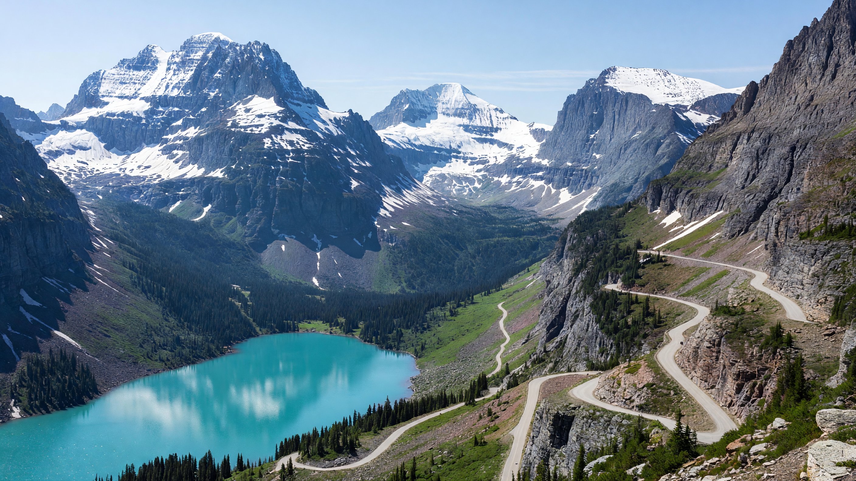
Many Glacier: The Valley Worth the Detour
Many Glacier is accessed from the east side via a separate road off U.S. Highway 89 north of St. Mary — it does not connect to Going-to-the-Sun Road. The extra driving is worth it without qualification.
The valley holds Some of Glacier’s most concentrated scenery: Swiftcurrent Lake, Josephine Lake, the Many Glacier Hotel on the lakeshore (historic, operated by Aramark as a concessioner), and the Grinnell Glacier trail — the hike that, if you do one long hike in Glacier, should probably be this one.
Grinnell Glacier Trail (7.6 miles round trip): The hike gains roughly 1,600 feet and takes most fit hikers four to five hours round trip. The route traverses lake shores, crosses a headwall, and arrives at the Grinnell Glacier itself — or what remains of it. The glacier has retreated dramatically in living memory, and comparing current photographs to the park’s historical archive (NPS maintains a repeat photography project documenting the retreat) is worthwhile before you go. You will still walk on the ice if conditions allow. Bring traction cleats for early season, bear spray at all times.
The Many Glacier Hotel, built in 1915, is the kind of historic park lodge that justifies the premium: a Swiss-chalet-style structure with five stories of balconies overlooking Swiftcurrent Lake and the peaks rising directly behind it. Aramark manages this property along with Lake McDonald Lodge on the west side and Glacier Park Lodge in East Glacier. Reservations open roughly 13 months in advance and the summer peak books out quickly — if you want a room at Many Glacier Hotel in July, plan to book in the prior spring at minimum.
Two Medicine and Cut Bank: The Quieter Corners
Two Medicine valley in the park’s southeastern corner is accessed via a short spur road off Highway 49 south of East Glacier. It is dramatically less visited than Many Glacier or the Road corridor, and the hiking here — particularly the route to Upper Two Medicine Lake and the trail toward Pitamakan and Dawson passes — offers genuine backcountry character without the crowds. Two Medicine Lake itself is beautiful, and the short paddle to a dock for a ranger-led boat tour is a legitimate option for families.
Cut Bank is even quieter — a small campground and a trail corridor into the park’s interior that sees a fraction of the traffic of other trailheads. For experienced backpackers, the Cut Bank to Triple Divide Pass route crosses the only point in the lower 48 where water drains to three oceans (Pacific, Atlantic via Hudson Bay, and Atlantic via Gulf of Mexico). The logistics are more demanding but the solitude is real.
Gateway Towns and Access
West Glacier sits at the park’s western entrance on U.S. 2, about 30 miles from the Kalispell/Glacier Park International Airport. Services are limited — a few motels, outfitters, and restaurants cluster near the entrance — but it is the right base for exploring the Lake McDonald corridor and the western Road.
Apgar is a small village within the park at the foot of Lake McDonald, with a visitor center, basic food service, and campground. It is not a gateway in the traditional sense but serves as a staging point for western-entry Road trips.
St. Mary at the eastern end of the Road is genuinely small — a cluster of lodging and services just outside the park boundary. The St. Mary Visitor Center is excellent and worth the stop. The view of St. Mary Lake from the Rising Sun area is one of the park’s best, especially at sunrise.
East Glacier (the town, not the park entrance) sits on the Blackfeet Reservation south of the Two Medicine entrance on Highway 49. Glacier Park Lodge — another Aramark-managed historic property, built in 1913 by the Great Northern Railway — anchors the town. East Glacier has a different character than the west side: quieter, less tourist infrastructure, and a direct connection to the reservation community.
Browning, 12 miles east of East Glacier on U.S. 89, is the tribal headquarters of the Blackfeet Nation. The Museum of the Plains Indian here is worth a deliberate stop — the collections document the culture, history, and art traditions of the Blackfeet and neighboring tribes. The east side of Glacier shares its boundary with the Blackfeet Reservation, and the park’s eastern landscape was central to Blackfeet territory for centuries before the reservation era. That context matters when you’re standing at the Chief Mountain border crossing or looking east from Logan Pass toward the plains.
For information about the Blackfeet Nation and tribal tourism, visit the Blackfeet Nation official website.
Getting There Without a Car: Amtrak’s Empire Builder
Glacier is one of a small number of national parks in the United States that is legitimately reachable by train. Amtrak’s Empire Builder — the Chicago-to-Seattle/Portland route — stops at East Glacier Park station (seasonal, typically late May through late September) and at West Glacier station. Whitefish, 25 miles west of the park, is an all-season stop with more lodging options and serves as a practical base.
Arriving by train at East Glacier gives you direct access to the east side of the park and a short walk to Glacier Park Lodge. The Empire Builder route information on Amtrak.com includes current schedules and seasonal stop status. For a park that rewards slowing down, arriving by train sets the right tone.
Wildlife: Bear Country Protocols
Glacier has one of the highest concentrations of grizzly bears in the lower 48 states. Black bears are also common. Both are part of the park’s intact ecosystem — and bear encounters, while uncommon on maintained trails, are real.
Bear spray is not a suggestion here. I carry it every time I set foot on a Glacier trail, and so does every person I hike with. It is effective against both grizzly and black bear charges at close range — more reliable than firearms in the evidence. Rent or buy at outfitters in West Glacier, Whitefish, or St. Mary. Know how to deploy it before you need it: safety clip off, held at the ready in a hip holster, not buried in a pack.
Beyond bears: bighorn sheep are frequently visible from the Road and near Logan Pass. Mountain goats crowd above the Highline Trail and the cliffs near Hidden Lake Overlook. Moose appear in the willows along McDonald Creek and in the Two Medicine valley. The park also holds wolves and mountain lions, though sightings are rare. Hiking in groups of three or more significantly reduces the risk of a negative bear encounter. Make noise on trails, especially in dense brush near streams.
Photography Notes
Three locations consistently produce the strongest images in Glacier:
Wild Goose Island Sunrise on St. Mary Lake: A tiny forested island in the middle of St. Mary Lake, framed by the valley’s flanking ridges and accessible from the Rising Sun area pullout. Arrive before civil twilight — the pink and orange light hitting the mountains behind the island as it reflects in still morning water is the postcard image of Glacier’s east side.
Lake McDonald Rainbow Rocks: The colorite cobblestones visible through the crystal-clear shallows of Lake McDonald’s shoreline near Apgar are a geological phenomenon (argillite and quartzite in deep reds, greens, and purples). Photographing them requires flat light or overcast conditions to minimize surface glare. A polarizing filter is essential here.
Hidden Lake Overlook: The boardwalk approach in mid-morning light, with the beargrass bloom in the foreground and the Continental Divide peaks behind, is one of the most approachable wildflower compositions in any national park. Peak bloom typically runs late June through late July depending on snowmelt year.
For the best natural-light conditions across the park: the east side faces west toward the Road and catches afternoon and evening light; the west side faces east and catches morning light on the peaks above Lake McDonald. Plan hike start times accordingly.
Frequently Asked Questions
Is the Going-to-the-Sun Road vehicle reservation required in 2025? No. The timed-entry vehicle reservation pilot that operated on Going-to-the-Sun Road from 2021 through 2024 was not continued for the 2025 season. You can drive the Road without advance vehicle reservations. However, the Logan Pass parking lot fills completely on clear summer days by mid-morning — arriving before 8 a.m. or using the free NPS shuttle system remains the practical strategy for accessing Logan Pass trailheads.
When does Going-to-the-Sun Road typically fully open? The alpine section between Avalanche Creek and St. Mary — including Logan Pass — typically opens to vehicles in late June or early July, depending on snowpack. There is no fixed annual date; NPS Glacier posts road status updates at nps.gov/glac as crews clear the route. The lower sections on both the west and east sides open earlier in spring.
Do I need bear spray in Glacier National Park? Yes, in practice, though it is not legally mandated in the same way helmets are required on motorcycles. Bear spray is the most effective deterrent against grizzly bear charges at close range, and Glacier has one of the highest grizzly concentrations in the lower 48. Every person hiking any trail — including the short boardwalk at Hidden Lake Overlook — should carry it and know how to use it. Rental and purchase options are available at park entrance areas and gateway towns.
How long does it take to drive Going-to-the-Sun Road end to end? The 50-mile drive takes a minimum of two hours if you stop nowhere and traffic is light. A realistic full-day itinerary adds all the stops: the Apgar Visitor Center, the Lake McDonald Lodge area, Avalanche Creek, the Road itself with turnouts, Logan Pass, the Sun Point walk, and St. Mary Lake at the east end. Most people find the drive plus one or two short hikes fills an entire day.
What are the best months to visit Glacier National Park? Late June through mid-September offers the widest range of accessible trails and the full Going-to-the-Sun Road experience. July and August are peak crowds — plan to arrive at Logan Pass before 8 a.m. September is consistently excellent: lighter crowds, fall color beginning on the larch and aspen, active wildlife, and crisp clear days. October brings dramatic color and very thin crowds but with real possibility of early snowstorm closures.
Does Glacier have Amtrak access? Yes. Amtrak’s Empire Builder stops at East Glacier Park station (seasonally, typically late May through late September) and at West Glacier station. Whitefish, 25 miles west of the park, is an all-season stop. It is one of the few national parks in the country where arriving by train is a practical option.
Glacier’s Gold Tier dark sky designation — part of the Waterton-Glacier International Peace Park transboundary designation — makes it one of the premier night sky destinations in the Northern Rockies. For a full comparison of Glacier alongside other top Western dark sky parks, see the stargazing guide for Western national parks.
Authority resources: