Most national parks lead with the dramatic. A rim that drops a mile. Glaciers calving into steel-blue water. A geyser shooting 150 feet into the Wyoming sky. Congaree National Park asks for something different from its visitors: patience, and a willingness to look closely at the ordinary-seeming surface of standing water, tangled root systems, and sky-scraping trunks that have been here since before the United States existed.
Located about 20 miles southeast of Columbia, South Carolina, Congaree protects 26,692 acres of old-growth bottomland hardwood forest — the largest intact expanse of this rare ecosystem remaining in North America. The park was established on November 10, 2003, when Congress elevated it from National Monument status (originally designated in 1976) to a full National Park. In the intervening two decades it has gained a devoted following among families, paddlers, birders, and the tens of thousands of people who enter the Recreation.gov lottery each spring for a chance to witness the synchronous firefly display that has earned the park genuine national fame.
If you haven’t been, here is what you should know before you go.
What Makes Congaree Ecologically Significant
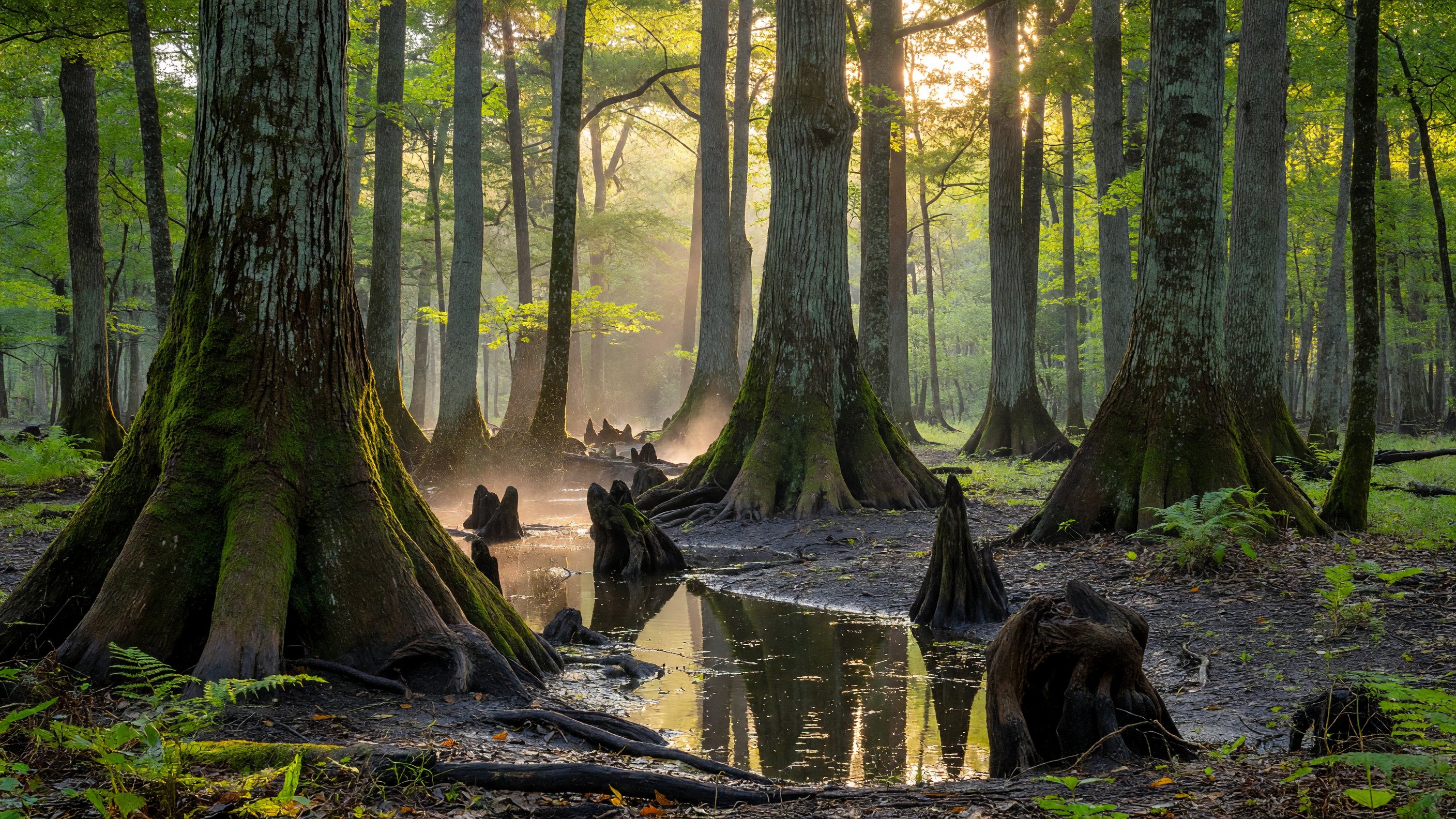
The term “bottomland hardwood forest” refers to lowland forest that forms on floodplains — ground that receives regular inundation from adjacent rivers, depositing nutrient-rich sediment and maintaining the wet-soil conditions that favor specific tree species. Congaree sits at the confluence of the Congaree and Wateree rivers, and the park’s forest floor floods roughly ten times per year when river levels rise. That flooding cycle, which would be a catastrophe for most land uses, is precisely what has sustained the ecosystem for millennia.
The trees that grow in these conditions are extraordinary. Bald cypress and water tupelo crowd the lowest, wettest areas; their knobby “knees” — woody projections that emerge from submerged root systems — cover the ground in rows like small sentinels. Farther up the slope, giant loblolly pines, cherrybark oaks, American elms, and swamp chestnut oaks form the upper canopy. The park hosts more than 25 national or state champion trees — species records measured by circumference, height, and crown spread. The tallest loblolly pine ever recorded, standing 169 feet, grew here.
The National Park Conservation Association’s overview of Congaree situates this ecosystem within the broader context of southeastern forest preservation. Less than one percent of the original bottomland hardwood forest that once covered the southeastern United States survives intact today. Congaree is its largest remaining block.
The Harry Hampton Visitor Center
The Harry Hampton Visitor Center sits near the park entrance off Old Bluff Road in Hopkins, SC. It is the right first stop for every visit — rangers here post current trail conditions (including which boardwalk sections are flooded), operate a small natural history exhibit, and sell trail maps. The visitor center also serves as the departure point for ranger-led programs, which run on Saturdays year-round and address topics from tree identification to flood ecology. Restrooms, water, and a picnic area are available adjacent to the building.
Hours vary seasonally; check nps.gov/cong for current times before you drive down. The park itself is open daily and has no entrance fee — one of the better deals in the national park system.
The Boardwalk Loop: The Park’s Most Accessible Feature
The Boardwalk Loop is where most visitors spend the bulk of their time, and with good reason. The 2.4-mile elevated boardwalk lifts you off the flood-prone forest floor on a solid, flat, paved surface that is wheelchair and stroller accessible along its entire length. There are no significant grades, no uneven terrain, and no technical challenge whatsoever — which makes it unusually inclusive for a backcountry-feeling experience.
What makes it remarkable is the forest it moves through. The boardwalk winds between massive trunks at eye level, passing cypress knees and root buttresses you can reach out and touch. The canopy closes overhead in a tunnel of green in summer. In spring, prothonotary warblers — startlingly gold against the dark bark — work the understory. Barred owls call in full daylight. Water stands in dark pools below the deck, and you can often spot slider turtles basking on logs or small fish moving through submerged vegetation.
For families with young children or visitors who use mobility devices, this is the headline feature of the park: a genuine old-growth forest walk with essentially no physical barrier to entry.
Plan 90 minutes to two hours for the full loop at a relaxed pace. Bring water regardless of the season — humidity is high even in spring and fall, and the boardwalk offers no shade on its few open stretches. Check the visitor center board for any flood-related closures before setting out; some sections may be temporarily underwater following heavy rainfall or river rise.
Accessibility specifics
The boardwalk surface is compacted pea gravel and recycled composite decking — firm, stable, and passable with a standard wheelchair or jogging stroller. The loop connects back to the visitor center without requiring backtracking. Accessible restrooms are available at the visitor center and at the boardwalk’s midpoint shelter. The inner spur trail to Weston Lake branches off the boardwalk but becomes unpaved, so families relying on wheels should plan for the main loop only.
Cedar Creek: The Paddler’s Park
From the water, Congaree is a completely different place. Cedar Creek — a slow, dark, tannin-stained waterway that winds through the park’s interior — offers more than 15 miles of marked canoe and kayak trail, beginning at the canoe launch off Old Bluff Road and threading through one of the wildest sections of the forest.
Paddling Cedar Creek puts you below the tree line, at water level, in a space where the cypress trunks rise straight up from the creek edge and the canopy closes overhead. You move through light and shadow at a pace the forest sets, not you. The creek is narrow in places and wide in others; side channels offer exploration opportunities for confident paddlers. American alligators are present along the creek, particularly from spring through fall — they are typically indifferent to quiet paddlers but should be given a wide berth and never approached or fed.
A full paddle of the creek’s marked trail takes most parties a full day. Bring more water and snacks than you think you need, a detailed waterproof map (available at the visitor center), and dress for immersion if you’re in a rental kayak rather than your own boat. No rentals are available within the park; several outfitters in Columbia offer kayak and canoe rentals for pickup and drop-off. Check the visitor center or the NPS trip-planning resources at nps.gov/cong for current water levels before committing to a full-day paddle — high flood periods can make navigation significantly more complex.
For families with children who paddle, the first two or three miles of Cedar Creek from the launch point give a satisfying taste of the experience without the full-day commitment.
The Synchronous Fireflies: Planning Around the Lottery
The event that has made Congaree nationally famous in recent years is the annual synchronous firefly display — and earning a spot to see it requires advance planning.
Photinus carolinus is a species of firefly found in isolated pockets throughout the southern Appalachians and the Southeast. Unlike most firefly species, in which males flash independently, Photinus carolinus synchronizes: thousands of individuals flash together in coordinated waves, then go dark, then flash again, in a rhythm that rolls through the forest like a living pulse. The display runs for approximately two to three weeks each year, typically from mid-May through mid-June, with the peak display varying by weather and temperature.
Because the firefly zone requires darkness to work — no white-light flashlights, no phone screens, no vehicle lights — and because demand has grown enormously, the park requires ticketed entry during the synchronous firefly viewing period. Passes are issued via a lottery run through Recreation.gov. Lottery registration typically opens in early spring for the May–June viewing season; visit nps.gov/cong well ahead of time to confirm current registration dates and procedures.
Winning a firefly pass allows you to park at a designated shuttle area and board buses to the viewing site. You will watch the display in near-total darkness, guided only by the fireflies themselves. Children who are old enough to stay quiet and comfortable in the dark without a flashlight will find it extraordinary. Those who may need light for comfort should plan for a year when they’re ready.
If the lottery is daunting or timing doesn’t work out, note that Great Smoky Mountains National Park runs a parallel synchronous firefly program at Elkmont, Tennessee — the same species, a similar lottery structure, and the same mid-May to mid-June window. Both programs fill quickly.
Trails Beyond the Boardwalk
For visitors who want to get off the elevated deck and onto the forest floor, the park offers more than 25 miles of trails across terrain that ranges from flat floodplain to upland pine forest.
Weston Lake Loop (4.5 miles, moderate) departs from the boardwalk and takes you around an oxbow lake formed when the creek changed course over time. The trail passes through cypress-tupelo slough with dense cypress knee fields and connects to the Cedar Creek bank at several points. It is unpaved and subject to flooding — check conditions before attempting.
Kingsnake Trail (approximately 12 miles, strenuous) follows Cedar Creek through the park’s interior and into its most remote sections. This is a half-day or full-day trail for experienced hikers comfortable with wet terrain and minimal facilities. Birders use it heavily during spring migration; it is one of the better trails in the Southeast for interior forest songbirds.
Bates Ferry Trail (2.2 miles round trip, easy) departs from Route 601 — not the main entrance — and follows the route of a 1920s river ferry road to the bank of the Congaree River. The trail ends at a steep riverbank with views of the floodplain. It is a quiet, underused alternative to the main visitor complex.
For a brief walk without the full boardwalk commitment, the Bluff Trail connects the visitor center to the boardwalk along a short upland path — useful for checking the forest feel before committing to longer distances.
Wildlife: What to Expect by Season
Congaree’s wildlife is diverse and in many cases underappreciated. The park’s combination of bottomland and upland habitats supports an unusual range of species.
Year-round: White-tailed deer are common throughout the park. River otters inhabit Cedar Creek and the slough areas; you’re most likely to spot them from a canoe. Bobcats range through the park but are rarely seen by day. Wild turkeys are frequently visible along the Boardwalk Loop, particularly in the early morning.
Spring: Peak bird migration brings neotropical songbirds — warblers, vireos, tanagers, and thrushes — through the floodplain in significant numbers. Prothonotary warblers nest in the park and are visible along the boardwalk from April onward. Spring flooding brings aquatic life to the surface.
Summer: Reptiles are most active — five-lined skinks, cottonmouth water moccasins (look but don’t approach), and occasionally American alligators in low-elevation creek areas. Firefly season runs from late May into June. Daytime temperatures frequently reach the mid-90s; the famous “Mosquito Meter” sign at the visitor center rates the day’s mosquito activity on a scale that experienced visitors take seriously.
Fall/Winter: Barred owls are vocal and highly visible. Waterfowl and raptors arrive as migrants. The leafless forest offers exceptional long views through the canopy.
A note on the Mosquito Meter
The Mosquito Meter is real, it is posted at the Harry Hampton Visitor Center, and it means something. Congaree’s floodplain is prime mosquito habitat, particularly from late spring through early fall. Long sleeves, long pants, and DEET-rated repellent are not optional on most summer visits — they are the difference between an enjoyable walk and a memorable misery. Bug head nets are not overkill for early-morning or dusk hikes from May through September.
Camping in the Park
Congaree offers two camping options, both primitive — no electrical hookups, no showers, no developed facilities.
Longleaf Campground is accessible by car and sits in the upland pine forest section of the park, elevated above the flood zone. It has picnic tables, fire rings, and nearby restrooms. Reservations are available through Recreation.gov and are recommended in spring and fall.
Bluff Campground is a backcountry site reachable on foot via the Bluff Trail from the visitor center. It is a short hike — under a mile — but qualifies as backcountry use; a free backcountry permit (available at the visitor center) is required. The site has minimal facilities and is excellent for those wanting a night in the forest without significant distance.
For full lodging options, Columbia is the gateway city, approximately 20 miles northwest. The city’s hotel inventory is extensive and the drive to the park is straightforward via Route 48.
Planning Your Visit: Practical Notes
Getting there: The park entrance is at 100 National Park Road, Hopkins, SC 29061. From downtown Columbia, take Route 48 (Bluff Road) southeast approximately 20 miles. GPS is reliable for this address.
Entrance fee: None. No America the Beautiful pass is required for entry, though the synchronous firefly timed-entry passes carry their own fee structure via Recreation.gov.
Best seasons: October through April offers the most comfortable temperatures and lowest humidity. Spring brings bird migration and early blooms but also higher flood probability. Summer is hot and buggy but delivers firefly season — the trade-off is real and most visitors who attend the firefly event consider it worthwhile.
What to bring always: Water (more than you think), insect repellent May through September, closed-toe shoes for anything off the boardwalk, a waterproof trail map.
For families: The Boardwalk Loop is genuinely excellent for strollers and young children. Plan for a shorter experience — 60 to 90 minutes — and focus on the immediate sensory environment rather than wildlife spotting. Kids who look closely at the root systems and cypress knees get a lot out of the walk.
Congaree occupies a small footprint by national park standards, but the density of ecological significance within its boundaries is exceptional. It rewards visitors who slow down — and the boardwalk, uniquely for a park of this character, makes slowing down accessible to almost anyone. For Southeast trip planning, see our full Park Guides directory.
Frequently Asked Questions
How big is Congaree National Park? Congaree encompasses 26,692 acres (about 41.7 square miles) in Hopkins, South Carolina, roughly 20 miles southeast of Columbia. Approximately 15,000 acres are designated wilderness.
When was Congaree designated a National Park? Congaree was established as Congaree Swamp National Monument in 1976 and redesignated as a National Park on November 10, 2003.
How do I get tickets for the synchronous fireflies? Timed-entry passes are issued via a lottery on Recreation.gov. Lottery registration typically opens in early spring for the mid-May to mid-June viewing season. Check nps.gov/cong for current dates.
Is the Boardwalk Loop wheelchair accessible? Yes. The full 2.4-mile Boardwalk Loop is wheelchair and stroller accessible — flat, paved, and firm for its entire length. Accessible restrooms are at the visitor center and at the loop’s midpoint shelter.
Are there alligators at Congaree? Yes. American alligators are present in low-elevation creek areas including Cedar Creek, most active spring through fall. Maintain safe distance and never feed them.
Can I paddle Cedar Creek without a guide? Yes. Cedar Creek is open to self-guided paddling with your own equipment. No rentals are available in the park; outfitters in Columbia offer kayak and canoe rentals. Check water levels at the visitor center before a full-day trip. For a broader look at paddling options across the national park system — including multi-day canoe routes and sea kayaking destinations — see the national parks kayaking and canoeing guide.
What is the Mosquito Meter? A sign at the Harry Hampton Visitor Center rating daily mosquito activity. From late spring through early fall, the floodplain supports heavy mosquito pressure. Long sleeves, long pants, and DEET-rated repellent are strongly recommended May through September.
Does Congaree have an entrance fee? No. The park is free to enter. A timed-entry pass via Recreation.gov is required only for the synchronous firefly event.