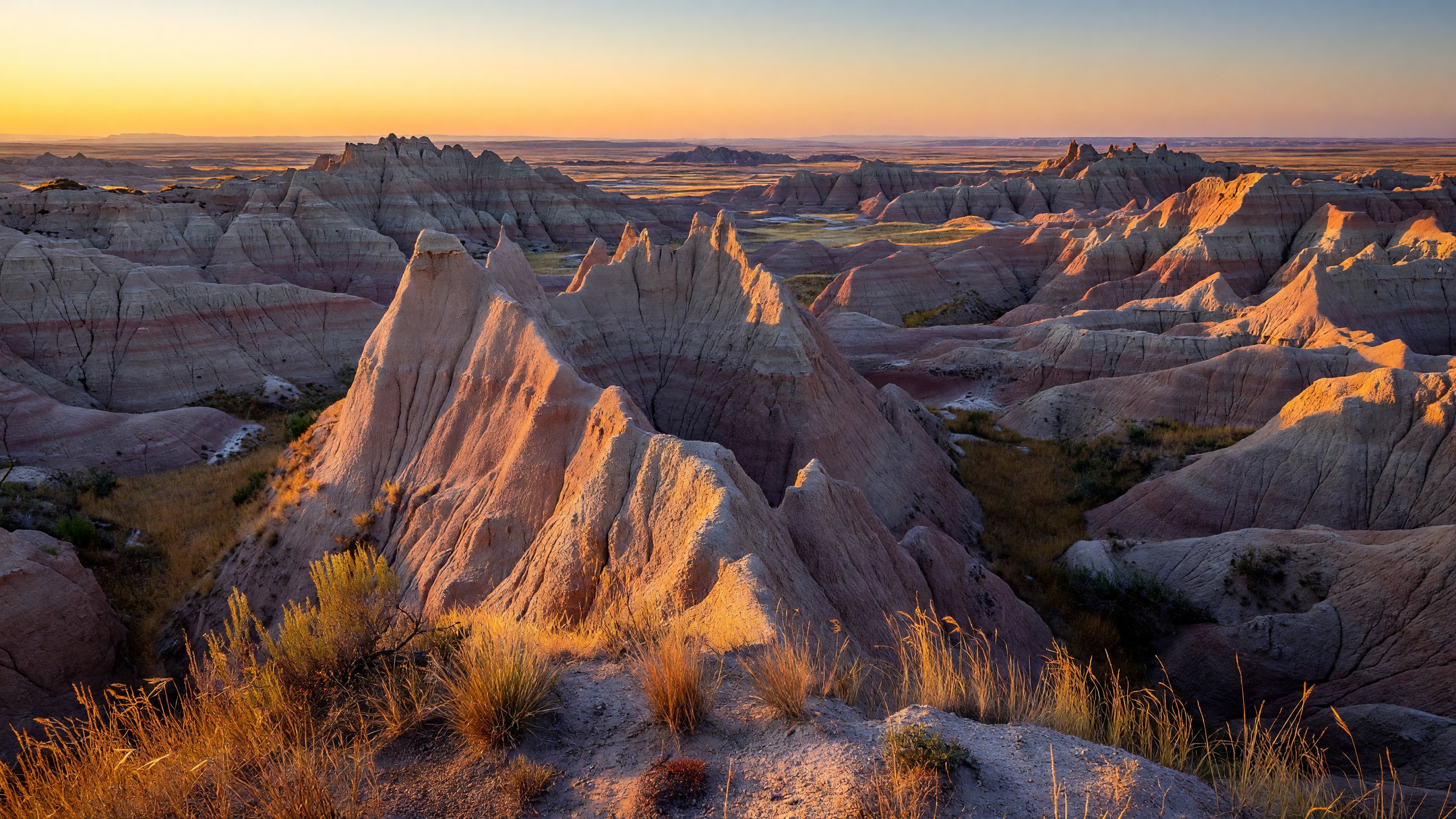
I first drove into Badlands National Park just before six in the morning, chasing the light. The plains had been flat and ordinary for two hours, and then — without announcement — the earth simply broke open. Hundreds of feet of eroded pinnacles, ridges, and gullied buttes dropped away from the road in shades of pink, rust, and bone-white, the formations catching the low sun at an angle that made them glow from the inside. I pulled over at the first overlook and stood there longer than I should have.
Badlands rewards that kind of attention. The park encompasses roughly 244,000 acres of the western South Dakota plains, protecting the most dramatic stretch of mixed-grass prairie in the country alongside one of the world’s richest Oligocene-epoch fossil beds. But what draws photographers in particular is the quality of the light here — and the constant, almost brutal pace of erosion that means the landscape is never quite the same twice. The buttes erode at roughly an inch per year, exposing new fossils, new textures, and new colors with every season.
There is more to this park than the Loop Road and the overlooks most visitors see. A second, quieter section — the South Unit, co-managed with the Oglala Sioux Tribe — sits largely beyond the tourist circuit, on land that carries a complex and often painful history. Getting that context right matters.
The Park in Overview: North Unit, South Unit, and the Badlands Formation
What most visitors experience is the North Unit, the main developed section accessed via SD Highway 240 (the Badlands Loop Road) between the Pinnacles and Northeast entrances near Interior and Wall. This is where the visitor center, Cedar Pass Lodge, the main campgrounds, and the Loop Road overlooks are concentrated.
Less visited but equally significant are the Stronghold District and Palmer Creek District, together forming the South Unit. These sections are co-managed by the National Park Service and the Oglala Sioux Tribe and sit largely within the Pine Ridge Indian Reservation. Access requires crossing tribal lands, and the road conditions are rougher — a high-clearance vehicle is advisable for reaching Stronghold Table. But the South Unit rewards those who make the effort with genuine solitude and a landscape that feels more wild and more historically resonant than the busy northern section.
The Oglala Lakota name for the badlands formations is Mako Sica — bad land — given for the same practical reason French-Canadian trappers called them les mauvaises terres: the terrain is brutally hard to cross. The Oglala Lakota also called the white clay hills Paha Ska. This land has deep cultural meaning far predating any national park designation, and visitors entering the South Unit especially should approach it with that awareness.
Badlands Loop Road: The Essential Drive
SD Highway 240, the Badlands Loop Road, runs approximately 30 miles through the heart of the North Unit formations. It’s the park’s backbone, and you could technically drive it in under an hour — but that would be a waste. Budget two to three hours minimum, more if you’re shooting.
Big Badlands Overlook, near the Northeast Entrance off I-90, is the logical starting point coming from Wall. The view here is panoramic and gives you the best sense of the formation’s scale before you descend into it. This overlook faces west, which makes it excellent for late-afternoon and sunset photography — the buttes catch the oblique light and the colors shift through golden yellow, deep orange, and eventually a cool blue-purple as the sun drops.
Yellow Mounds Overlook is one of the Loop Road’s most photographically distinctive stops and one that gets skipped by visitors who don’t know what they’re looking for. The mounds here are a pale ochre-yellow, the result of ancient soil horizons that predate the current erosion cycle — a geological layer distinct from the typical gray and tan buttes. In morning light, the yellow mounds glow in a way that photographs extremely well against a blue sky. Don’t rush past this one.
Pinnacles Overlook sits at the western end of the Loop Road and offers a different angle on the formations — looking back east along a ridgeline of eroded spires from a point that’s notably less crowded than the eastern overlooks. This section of the road is also where you’re most likely to encounter bighorn sheep on the roadside, particularly in early morning. The overlook itself is accessible (paved, level surface), making it one of the best viewpoints in the park for visitors with mobility limitations.
Razorback Road Overlook and several unnamed pull-outs along the Loop Road allow you to step down directly onto the formations — something you can do essentially anywhere in the park where the terrain isn’t fenced. Taking a short walk down from the road into the formations changes the photography entirely; shooting from slightly below the ridgelines rather than from above flattens perspective in a useful way and eliminates parking lot context from your frames.
Photography Routes: Light, Timing, and the Best Shots
Badlands is a photographer’s park in a way that few places are — the erosion textures are extraordinary, the wildlife is accessible, and the light at the edges of the day is genuinely exceptional. Here is how I think about the shooting schedule.
Sunrise: Door Trail and the Northeast formations. The Door Trail, a short boardwalk-and-dirt path just off the Loop Road, faces roughly northeast and catches the first light on the butte faces in a way that emphasizes texture over color. Arrive 20 minutes before sunrise and position yourself at the formation edge where the boardwalk ends and the open terrain begins. The first 15 minutes of direct sun produce a raking light that makes every erosion channel and clay layer visible. This is the shot.
Midday: Yellow Mounds and fossil photography. The midday light is harsh for most landscape work, but it’s useful for macro and close detail photography — the fossil-bearing layers in the mudstone are best examined in flat overhead light where you can see surface texture without shadow. The Yellow Mounds Overlook also holds its color saturation reasonably well in flat light when other areas look washed out.
Late afternoon and sunset: Big Badlands Overlook, the formations south of the road. The west-facing sections of the Loop Road catch the warm late light at a low angle that brings out the full color range of the sedimentary layers — the pinks and reds in the iron-oxide rich bands, the grays of the volcanic ash layers, the near-white of the calcium carbonate deposits. Big Badlands Overlook is the standard sunset position, but if you have time, drive south from the Conata Basin area on any of the informal tracks and find a private viewpoint well off the road.
Night: Sage Creek area and Cedar Pass. Badlands is a designated International Dark Sky Park, and on a clear moonless night the Milky Way is visible overhead with remarkable clarity — 7,500 stars by some estimates on optimal nights. The Sage Creek Wilderness Area, reached via the unpaved Sage Creek Rim Road from the North Unit’s western section, has essentially no artificial light within view. For star trails or Milky Way arches over the formations, this area is unrivaled. Cedar Pass near the visitor center is more accessible and still very dark.
Wildlife: A Functioning Prairie Ecosystem
The mixed-grass prairie here is the real ecological story, and it’s one that visitors sometimes underestimate while they’re focused on the geology. Badlands protects one of the last large, functioning temperate grassland ecosystems in North America — and in recent decades, active conservation work has brought several species back from near-extinction here.
Bison were extirpated from the region in the 19th century. The park’s herd today descends from animals reintroduced beginning in the 1960s and 1970s and now numbers roughly 1,200 animals, making it one of the larger bison herds on public land in the country. The herd is managed for genetic diversity and moves freely across the prairie sections of the North Unit. They are visible year-round from the Loop Road and from trails, often in large groups during summer. Keep a minimum 100-yard distance — bison are fast, unpredictable, and genuinely dangerous when approached.
Black-footed ferrets are the conservation headline. The species was declared extinct in 1979, rediscovered in a single Wyoming prairie dog colony in 1981, and subsequently pulled back from the absolute edge by a captive breeding program run by the U.S. Fish and Wildlife Service. Badlands became one of the first reintroduction sites in 1994, establishing a wild population in the park’s prairie dog towns. The program is ongoing — ferrets are still federally listed as endangered — but the Badlands population is one of the healthiest in the recovery effort. Ranger-led nighttime spotlight tours run seasonally and give you a real chance of spotting ferrets active in the prairie dog colonies after dark.
Bighorn sheep were reintroduced in the 1960s after being absent from the region for decades and are now reliably found on the rocky faces of the North Unit formations, particularly near Pinnacles Overlook and along the western Loop Road. They’re most visible in the morning and evening hours when they move down from the high formations to graze.
Prairie dogs are the keystone species that holds the ecosystem together. The black-tailed prairie dog colonies here support ferrets, burrowing owls, prairie falcons, swift fox, and a long list of other species that depend on their burrow networks and their grazing disturbance. The Conata Basin area in the North Unit has historically held some of the largest prairie dog towns in the park and is the core ferret recovery area.
Swift fox are nocturnal, small (roughly cat-sized), and often overlooked on species lists — but Badlands is one of the better places in the Great Plains to encounter one. They den in abandoned prairie dog burrows and hunt the grassland edges at dusk and dawn. A slow drive along the Loop Road at last light, scanning the roadside with patience, produces sightings more often than most visitors expect.
Key Hikes: Getting Into the Formations
Trail hiking at Badlands is genuinely unusual compared to most national parks — you can leave marked trails almost anywhere in the formations and simply walk cross-country, picking your own line through the buttes. That freedom, combined with a handful of established trails, gives hikers of every ability level something meaningful to do.
Notch Trail (1.5 miles round-trip, moderate/strenuous). This is the most characterful trail in the park. It begins as a canyon walk between high formation walls, then reaches a log ladder — an actual wooden ladder bolted to the canyon wall — that you climb to gain a narrow ledge above the canyon floor. The ledge section has some exposure (not technical, but not suitable for those with significant fear of heights), and the trail ends at an overlook above the White River valley with one of the most expansive views in the North Unit. I have done this trail four times at different hours; the early morning, when the canyon is still in shadow and the valley below catches the first light, is best.
Castle Trail (10 miles round-trip, easy/moderate). Castle Trail is the longest maintained trail in the park, running through open mixed-grass prairie and the formations at the park’s interior. Out-and-back, it’s a full-day hike; it can also be combined with Medicine Root Trail or Saddle Pass for a varied loop. The interior prairie sections are where you’re most likely to see bison without other hikers nearby. Carry more water than you think you need — the prairie offers no shade and the distance is deceptive in the flat light.
Saddle Pass (0.25 miles, strenuous). A short, very steep scramble up a soft clay formation face that connects the Loop Road to the Castle Trail prairie. It’s the most physically demanding trail in the park per unit of distance — climbing directly up a crumbling butte face with hand-and-foot scrambling required — but it’s over quickly and the top offers an abrupt change of perspective from formation country to open grassland.
Door Trail (0.75 miles round-trip, easy). The Door Trail follows a boardwalk through a natural opening — the “door” — in the formation wall, then continues on a marked dirt trail into the formation interior. It’s accessible from the boardwalk section, excellent for families, and one of the best sunrise positions in the North Unit as described above. Nearby Window Trail is similarly short and easy.
The South Unit: Stronghold Table and Oglala Lakota Land
The South Unit deserves a careful introduction. The Stronghold District and Palmer Creek District sit within the Pine Ridge Indian Reservation and are co-managed by the National Park Service and the Oglala Sioux Tribe under a 1976 agreement. The park’s enabling legislation recognized tribal interests in these lands, which were used for U.S. Air Force bombing range training from World War II through the 1960s — unexploded ordnance still exists in some areas, and visitors must stay on established roads.
Stronghold Table is the most significant destination in the South Unit — a high, flat-topped butte that was one of the last sites of the Ghost Dance movement in 1890–1891, when Lakota people gathered on the table’s defensible height during a period of extreme tension with the U.S. government. The Wounded Knee Massacre on December 29, 1890 — in which U.S. Army soldiers killed between 250 and 300 Lakota men, women, and children — occurred approximately 15 miles from Stronghold Table, just outside the current park boundary at what is now the Wounded Knee National Historic Landmark on the Pine Ridge Reservation.
The cultural framing here is not ancillary to the visit — it is the visit. For visitors entering the South Unit, the National Park Conservation Association’s resources at npca.org provide useful context, and the Oglala Sioux Tribe’s official resources at the tribal website offer the community’s own perspective on land and history that no federal publication fully captures. Approach Stronghold Table with the awareness that this is a place of living cultural and spiritual significance, not simply a scenic overlook.
The road to Stronghold Table is unpaved and can become impassable when wet. Check conditions before attempting the drive, and allow a full half-day for this section.
Gateways and Logistics
Wall is the most practical base for the North Unit, 8 miles from the Northeast Entrance via I-90. It’s a small town built substantially around the tourism economy, anchored by the famous Wall Drug store — an American roadside institution that has been advertising itself on billboards since 1936. The lodging options are modest but functional, and the proximity to the park entrance makes early-morning arrival straightforward. Badlands pairs naturally with Wind Cave National Park approximately 80 miles to the south in the Black Hills corridor — see our Park Guides index for the full Great Plains and Rocky Mountain region listings.
Interior sits just south of the Ben Reifel Visitor Center near the park’s center and is the quieter alternative — a small community with minimal services but convenient for visitors who want to be close to the formations without the Wall crowds.
Pine Ridge, to the south on the Pine Ridge Indian Reservation, is the gateway for the South Unit and the seat of the Oglala Sioux Tribe government. There is no significant tourism infrastructure in Pine Ridge oriented toward park visitors — this is a community with its own priorities, not a gateway town in the conventional sense. Visitors planning South Unit access should fuel up and prepare before leaving the main highway corridor.
Lodging, Camping, and Staying in the Park
Cedar Pass Lodge is the only in-park lodging, operated by a concessioner and open generally from late April or early May through October. The lodge offers simple, clean cabin-style units near the Ben Reifel Visitor Center and a restaurant. Reservations book out well in advance for summer dates. Check the current season dates directly with the lodge, as the exact opening and closing dates shift slightly year to year.
Cedar Pass Campground is the main developed campground, also near the visitor center, with basic amenities (flush toilets, some hookups in the developed loop). It fills on summer weekends and requires reservations through Recreation.gov during peak season.
Sage Creek Primitive Campground is free, first-come, and as advertised — primitive. No water, no facilities, pit toilets only. It sits in the western Sage Creek Wilderness Area, which offers the best dark skies in the park and the best chance of encountering bison grazing near your tent at dawn. It is genuinely wonderful. Bring everything you need, including more water than seems necessary.
Seasonal Considerations
Summer (June–August) is the busiest season and also the most physically demanding. Temperatures on the formations regularly exceed 100°F, surfaces radiate heat from the clay substrate, and shade is nonexistent on most trails. If you visit in summer, plan all hiking for before 9 a.m. and after 5 p.m., carry at minimum a liter of water per hour of activity, and do not underestimate the heat.
Spring and fall are the photographer’s seasons. Late May and early June bring wildflower blooms on the prairie and comfortable hiking temperatures. September and October offer cooling temperatures, lower crowds, dramatic storm light, and better wildlife behavior as animals move more actively with the season change. The fall light — lower, warmer, and at better angles to the formations — is exceptional.
Winter is cold, often bitterly so, but produces striking snow-and-formation landscapes that relatively few people see. The Loop Road stays open year-round; Cedar Pass Lodge and the main campground are closed. Sage Creek is accessible and even more isolated.
Accessibility
The Pinnacles Overlook and Big Badlands Overlook are both paved and level. The Door Trail has a boardwalk section that is accessible for the first portion before transitioning to a dirt path. The Ben Reifel Visitor Center and its exhibits are fully accessible. Most Loop Road pull-outs are paved. The formations themselves and the backcountry trails are not accessible; the terrain is loose, uneven, and steep.
For current accessibility details, the NPS Badlands accessibility page maintains current information.
Frequently Asked Questions
What is the total size of Badlands National Park? Badlands National Park encompasses approximately 244,000 acres, protecting a combination of eroded butte formations and mixed-grass prairie. It is one of the largest intact temperate grassland ecosystems in North America.
Are there two separate sections of the park? Yes. The North Unit contains the main visitor infrastructure — Loop Road, visitor center, Cedar Pass Lodge, and most developed trails. The South Unit (Stronghold and Palmer Creek Districts) is co-managed with the Oglala Sioux Tribe within the Pine Ridge Indian Reservation. The South Unit is less developed, requires high-clearance access, and carries significant Oglala Lakota cultural history.
When were bison reintroduced to Badlands? Bison were reintroduced to Badlands beginning in the 1960s and 1970s. The current herd numbers roughly 1,200 animals and is managed for genetic diversity across the park’s mixed-grass prairie.
What is the black-footed ferret recovery program at Badlands? The black-footed ferret was declared extinct in 1979, rediscovered in Wyoming in 1981, and reintroduced at Badlands in 1994 as part of a U.S. Fish and Wildlife Service captive breeding and reintroduction program. Badlands remains one of the primary wild recovery sites. The species is still federally listed as endangered. Ranger-led spotlight tours offer the best chance to see ferrets in the wild during summer.
Does the Notch Trail actually have a log ladder? Yes. The Notch Trail (1.5 miles round-trip) includes a log ladder bolted to a canyon wall that climbs to an exposed ledge section above the canyon floor. It is not technically difficult but does involve some height exposure. The trail ends at an overlook above the White River valley.
What is the best time to visit Badlands for photography? Spring (late May–June) and fall (September–October) offer the best combination of manageable temperatures and favorable light angles. For specific shots: sunrise at Door Trail for raking light on the northeast formations; sunset at Big Badlands Overlook for color on the west-facing buttes; nighttime at Sage Creek for dark-sky Milky Way photography.
Is the South Unit open to visitors? The South Unit (Stronghold and Palmer Creek Districts) is accessible to visitors but requires crossing tribal lands, a high-clearance vehicle for Stronghold Table, and awareness that portions of the former bombing range contain unexploded ordnance — stay on established roads. Check road conditions before visiting. The area carries significant Oglala Lakota cultural and historical significance.
What wildlife can I see at Badlands? The park’s mixed-grass prairie supports bison (herd of ~1,200), bighorn sheep, black-footed ferrets (nocturnal, best on ranger spotlight tours), prairie dogs, swift fox, pronghorn antelope, and 206 documented bird species including prairie falcons, ferruginous hawks, and burrowing owls.
For current conditions, entrance fees, campground reservations, and ranger program schedules, the official Badlands NP site is the authoritative source. The National Park Conservation Association publishes independent conservation and cultural context for the park. The U.S. Fish and Wildlife Service maintains current information on the black-footed ferret recovery program nationally.